Just far enough out of reach to keep big crowds away, but not so far as to make a day-trip an exhausting affair, Jinhuang Hot Spring (近黃溫泉) is a nice winter escape for your next visit to Taitung County. The pools are numerous, the water is the perfect temperature and the walk in is not too challenging, though you will have to get your feet wet.
The adventure starts in the county’s Jinlun Village (金崙), which is accessible by train, but you’ll want to have your own car, scooter or bicycle for this trip. If you arrive by train, walk up to the main road and rent a scooter from one of the shops near the 7-Eleven. Head west past the red bridge (do not cross it) and out of the village. Right after the next village, called Liciou (歷坵) but signs for it are hard to find, take not the first left down to the Rulakes Suspension Bridge, but the second left down to another bridge. On the other side of the river, continue parallel to the river until you encounter yellow plastic road barriers and then park wherever you can.
If you have a scooter and good insurance, you can possibly skirt the barriers and continue further down the road, but get off and look first. When we visited, the soil underneath the concrete surface of the outer half of the road just beyond the barrier was completely washed out, leaving just a slab of concrete hanging in mid-air. That still didn’t stop one brave driver from taking his car across it when we visited.
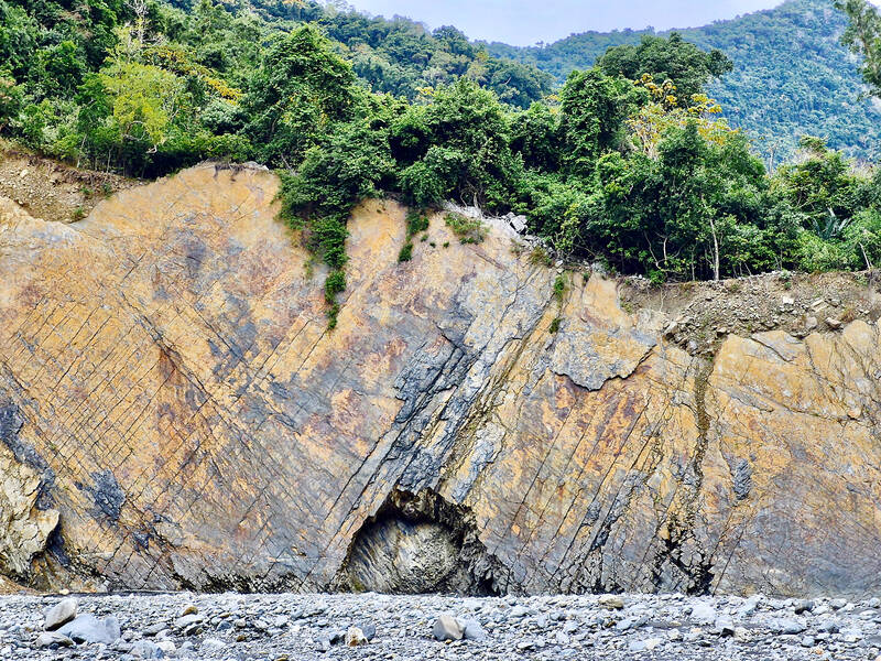
Photo by Tyler Cottenie
AN EASY RIVER WALK
We continued on foot to the end of the road, which used to descend all the way to the riverbed. Now, one switchback has disappeared in a landslide, so we took a shortcut down to the lower level and then walked down the landslide itself to the riverbed about 5 meters below.
The walk to the hot spring is quite straightforward from here: follow the river upstream for about two hours. In rubber boots, I was able to make it all the way to the hot spring, having only removed my boots to cross deeper water once. My friends wore river-tracing shoes and crossed 10 to 15 times, but the current was slow and the water only knee-deep. As far as river walks go, this one was quite tame. Erosion and the ever-shifting course of the river have also created some stunning scenery that made this a very pleasant stroll.
Photo by Tyler Cottenie
After about 2km, you will pass a spot marked as Jinhuang (近黃) on Google Maps just before a fork in the river. This is not the hot spring, but rather the location of an abandoned village of the same name settled in the Japanese era. Continue along the main river (left at the fork) for another 2km until the riverbed widens before another major fork. There is an unusual “false island” of treed higher ground surrounded by stony riverbed, the result of erosion by the river at a time when its course ran nearby.
HISTORY NEARBY
As we took a short break at the false island, my friend indicated the stream approaching from the left side of the fork. He said that this is where he came out from a cross-island hike on the Qing Dynasty-era Kunlunao Trail (崑崙坳古道) a few years ago, and that there were traces of the trail and a Qing military encampment just a kilometer up the river.
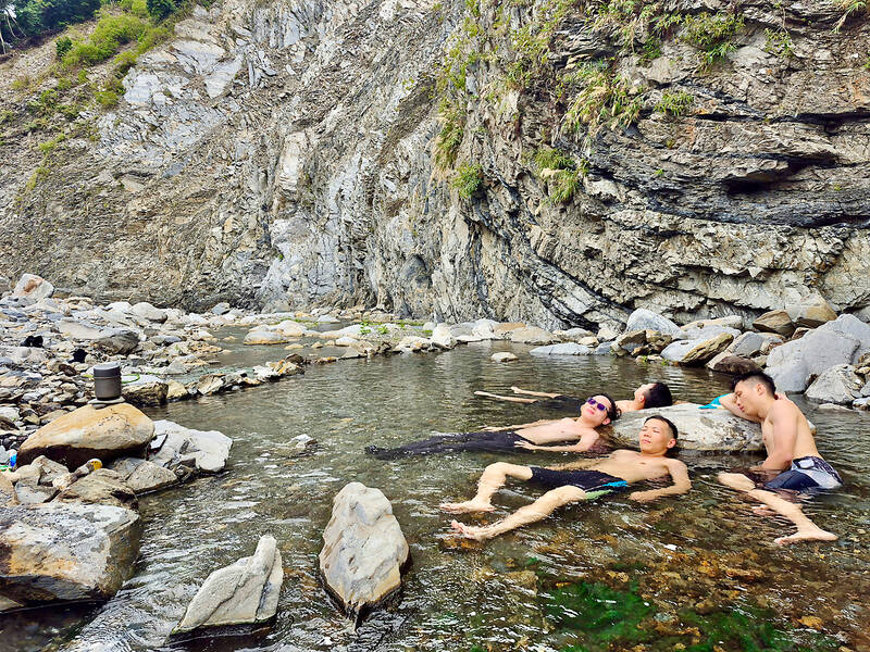
Photo by Tyler Cottenie
It had been less than two hours of easy walking in cool weather and we were almost at the hot spring. There had been hardly any challenge at all, neither physical nor technical. After listening to my friend’s description of the remains, I decided to make a quick side trip to look for them before going for a soak. Surprisingly, no one else wanted to join.
Fifteen minutes up the left stream, the river forked again. I took the right fork, then immediately headed to the left (southern) edge of the riverbed and up into the forest. Right on the ridge, I found a square, meter-high stack of stones, purpose unknown, but certainly manmade. Further uphill and a bit to the left, I entered a large area where the trees were sparse and the ground appeared artificially levelled. The presence of two stone walls in an “L” shape — and the fact that neither the stones’ shape nor their arrangement resembled those of typical indigenous stone houses — confirmed that I had likely reached the site of a Qing encampment on the trail.
Behind the flat area, I came across an obvious raised trail with stone reinforcement along the edge, ending at a stone staircase that went straight up a hill, a clear sign of a route designed by the Qing, not the Japanese. Having found what I had been looking for and not wanting to delay my hot spring arrival any longer, I headed back downriver to the false island. From here, I turned left and followed the main riverbed for 10 more minutes until I reached Jinhuang Hot Spring.
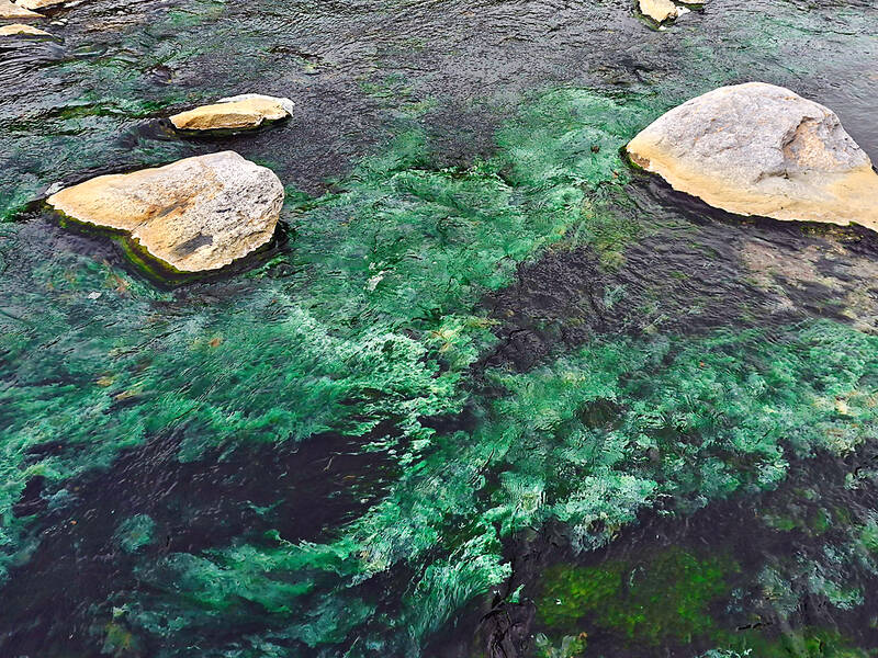
Photo by Tyler Cottenie
A SOAK IN NATURE
The river itself is on the far right (north) side of the riverbed, while the hot spring is tucked up against a steep slope on the far left (south) side. Hot water bubbles up from the ground and flows along the rocks for around 300 meters before disappearing underground again. We measured the temperature at a very comfortable 39°C.
All along this hot spring river, there are several pools that have been dug deep enough to lie down and soak in, and if you have time, it would be easy to make these even deeper or make a new pool of your own. At the lower end of this hot river is the biggest pool of all, easily 5 meters across by 10 meters long and waist deep, making it suitable for 20 or 30 people to soak all at once if needed.
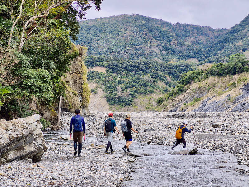
Photo by Tyler Cottenie
When we arrived, there were eight other people in three groups there; an hour later, we were the only ones left. As it was a weekend and a cool, cloudy day perfect for hot springs, we wondered why there were so few visitors. Perhaps it’s the access road that turns some people off, or the two-hour hike. Perhaps Jinlun is just a bit too remote for city folk from the west or the north. Or perhaps people can’t be bothered to apply for the required permit, though the process is quite simple.
To apply online, go to: hike.taiwan.gov.tw/en/apply_1.aspx and select “Natural Conservation Area,” and then “Dawushan Nature Reserve.” Set the trip duration to 1 day, write “Jinhuang Hot Spring” for “Application Area” and “Jinlun” for both entrance and exit points. Choose the second of the black text options for “Application Purpose,” which have not yet been translated. Skip the Upload Files section, confirm, and submit. Apply at least 5 days in advance: for a Saturday trip, apply on Monday at the latest. The fine for entering with no permit is a minimum of NT$30,000.
We would have loved to spend the night there next to the hot spring, but the permit system only allows day trips, so we reluctantly packed up and began the two-hour walk back to the car. We will likely be back again next year — if the spring is still exposed, that is. Hot springs are frequently buried by landslides or flooded out by rivers that change course, so it’s always wise to get in some soaking while the soaking is good. And this year at Jinhuang, it’s very good.

Ajay Verma, a consultant gastroenterologist at Kettering general hospital in Northamptonshire, says our gut is a “complex machine.” “It is constantly providing us with the nutrition we need, initially to grow and develop, and then for us to survive, thrive and repair from injury and illness.” How can we keep it functioning well? Put simply: “Make sure what you put into it is balanced, and that you clear out its waste products adequately,” Verma says. “In a general gastroenterology clinic, the most common conditions we see are irritable bowel syndrome (IBS), gastroesophageal reflux disease, inflammatory bowel disease and constipation,” says Nisha
The arithmetic is straightforward and uncomfortable. By the end of 2025, Taiwan had committed itself to a 50-30-20 electricity mix — half natural gas, 30 per cent coal, 20 per cent renewables. The Ministry of Economic Affairs’s (MOEA) own monthly energy reports tell a different story. Natural gas reached 47.8 per cent of generation last year. Coal stood at 35.4 per cent, comfortably above its target ceiling. Renewables came in at 13.1 per cent, well short of the 20 per cent Taipei had pledged a decade earlier. Installed renewable capacity reached roughly half of the 12 gigawatts (GW) the government

Last week US President Donald Trump was asked by a reporter whether he would speak on the phone to the President of Taiwan. “l’ll speak to him. I speak to everybody. We have that situation very well in hand,” Trump said. This marked the second time in a couple of weeks he had said he would talk to the President of Taiwan. In 2016 he famously took a call from then-president Tsai Ing-wen (蔡英文), when he was president-elect. Despite warnings that the apocalypse was nigh because of a phone call, the world quickly forgot about the conversation between two democratically-elected presidents.
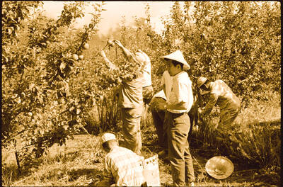
May 25 to May 31 Few believed that apples could be cultivated on a commercial scale in Taiwan’s high mountains. When horticulturalist Cheng Chao-hsiung (程兆熊) first proposed the idea in 1955, both American and Taiwanese colleagues dismissed it as implausible, arguing that temperate fruit could not be reliably grown on a subtropical island, especially on rugged terrain. However, it was this terrain in the Central Mountain Range where many Chinese Civil War veterans were resettled in the late 1950s. With limited job prospects and no family in Taiwan, they were placed on cooperative farms aimed toward self-sufficiency. Some say the conditions