The ghost of Chiang Kai-shek (蔣介石) still looms in the mountain town of Jiaobanshan (角板山) in Taoyuan County’s Fusing District (復興區). The iconic suspension bridge — the longest of its type in Taiwan at 303m — is allegedly named after his hometown of Xikou (溪口), China, and so is the indigenous Atayal village beyond it.
So explains the sign at the entrance to the bridge, but some sources such as the Taiwan Indigenous People’s Portal say that it was the Japanese who renamed the village from the original Rahaw. Xikou literally means “river mouth,” and the area is where the Shihlang River (詩朗溪) converges with the Dahan River (大漢溪).
In any case, Jiaobanshan was one of the former president’s favorite places to stay in Taiwan. The view across the river reportedly reminded him of home, and he once referred to it as his “second hometown” (although he has said that about several places). Pictures of him happily barbecuing with his family and playing with his grandsons can be seen in the exhibition hall at Jiaobanshan Park, which was revamped in late 2020. Chiang stayed at a wooden structure originally built for former Japanese crown prince Hirohito, but it burned down in 1992 due to an electrical fire.
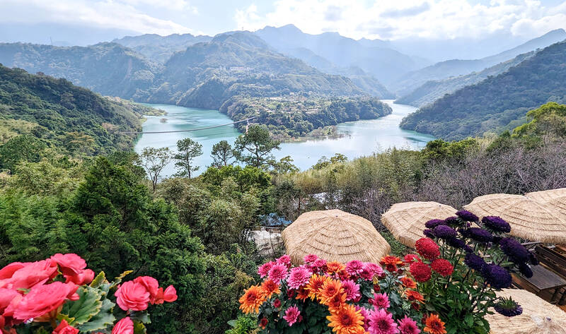
Photo: Han Cheung, Taipei Times
Also celebrated locally is favorite son Losing Watan, an Atayal doctor, indigenous activist and provincial assemblyman who was executed in 1954 during White Terror.
Just over an hour’s drive from Taipei, the area’s rich history, hot springs and mountain scenery are definitely worth some in-depth exploration, especially if you have a car. After spending two days here, there are still quite a few things I want to return to check out.
EXPLORING XIKOU
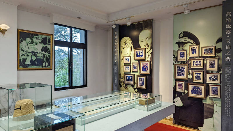
Photo: Han Cheung, Taipei Times
Arriving in Jiaobanshan around noon, we headed straight to Forest House Cafe (森林水岸咖啡), which as several Google reviews suggested, offers okay food with amazing views. Situated on the hillside facing a bend in the Dahan River, one can see the entire valley and the impressive suspension bridge below. There’s an elevated viewing deck to get a better look.
Downhill from the restaurant is the entrance to the bridge (NT$50), reached via an unexpectedly long descent on wooden steps. Completed in 2018, the structure is surprisingly stable — I had expected it to at least shake a bit. The panoramic views are splendid, and the concrete towers of the previous bridge can be seen along the way.
Ruins of the very first bridge, built in 1922, can also be visited nearby. There’s no mention of this on site, but in town there’s a display about a terrible collapse in 1951 that killed one and seriously injured dozens.
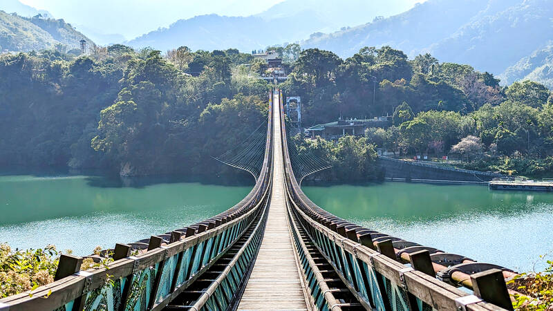
Photo: Han Cheung, Taipei Times
Immediately on the other side is the entrance to Xikou Village, which contains an indigenous plaza with food stalls and shops. It’s very quiet past the statue of Losing Watan, and we wander up the hill to see the cute local Catholic church with good vistas of the river.
I saw a sign for an Old Canal Ancient Trail (舊水圳古道), but there was no time to hike it as the bridge closes at 4pm and we had to get back to the other side. Another place I wanted to visit is nearby Kinyawpan Village (better known as Lofu, 羅浮), where there’s a memorial park to Losing Watan. It’s also famous for its hot springs.
CHIANG’S LEGACY
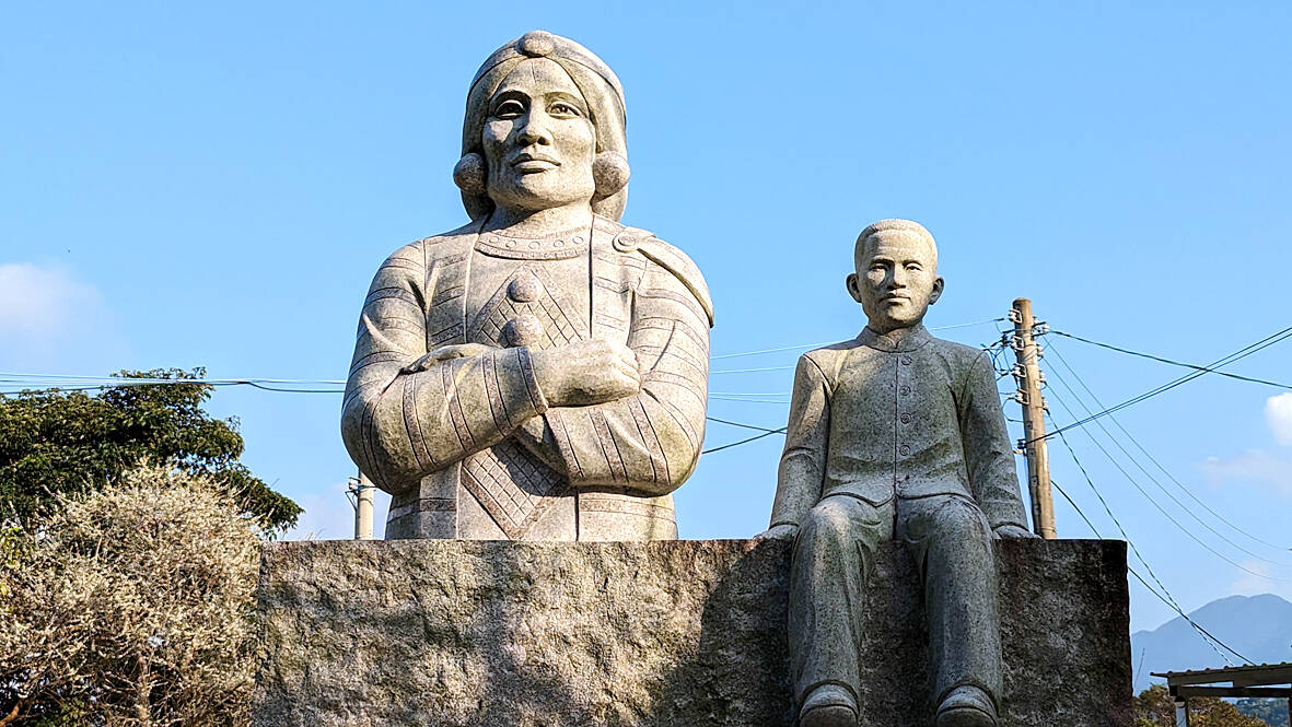
Photo: Han Cheung, Taipei Times
Wander south on Jiaobanshan’s main drag, which is lined with indigenous restaurants and shops selling dried mushrooms and other goods, and hang a left before the Fuxing District Office.
Make another left at Zhongxiao Road (忠孝路) to find a “time corridor” with old photos and panels detailing the area’s history in Chinese, English and Japanese. It takes a while to read everything, but it’s definitely worth your time. You’ll not only learn about the indigenous people and their conflicts with the Japanese, but also a labor draft in 1953 to expand the road so that Chiang could enjoy a more comfortable ride in from Taipei.
This last bit is not mentioned in the Jiaobanshan Park, which includes very sympathetic photographic displays of Chiang and his family. The grounds are quite expansive, with lush plum and cherry blossoms painting the landscape white and pink. The park Web site says that the plum blossoms are in full bloom until the end of January, but there still might be some remaining. The outdoor cafe offers quality coffee and tasty dumplings.
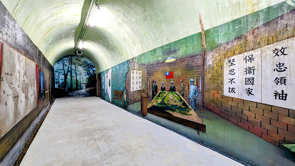
Photo: Han Cheung, Taipei Times
The most fascinating part, however, is the escape tunnel and shelter located beneath the site. Built in 1963 and opened to the public in 2016, the 100m passageway is now adorned with 3D paintings of wildlife, indigenous culture and army imagery. It’s still rather creepy, and the large mural in the middle suggests that it was meant to be a command center in case of war. There’s also an old camphor office explaining the industry’s illustrious past here, but again we ran out of time.
HIKING AND SOAKING
To satisfy our hiking urges, we tackled Dongyan Mountain (東眼山, NT$80 on weekdays and NT$100 on weekends), one of Taiwan’s “little 100 peaks” at 1,212m. Don’t trust the time on the signs if you’re reasonably fit; it does not take seven minutes to walk 120 meters. It’s a fairly straightforward and easy hike lined with steps, and on a good day hikers can see Taipei 101 on the summit.
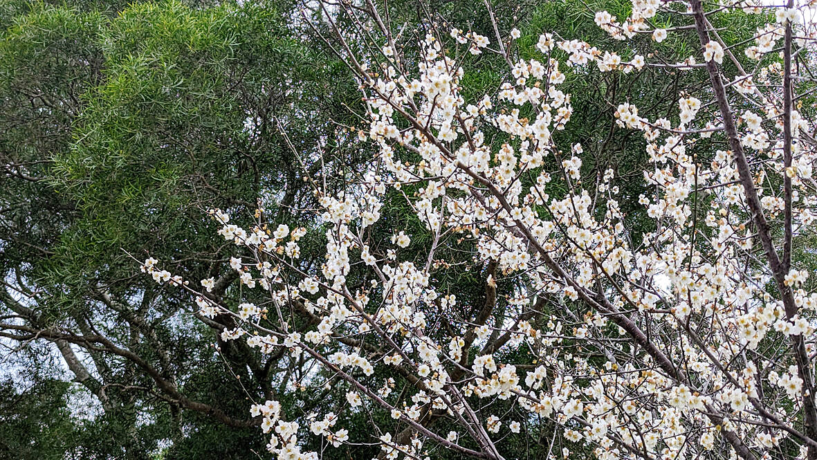
Photo: Han Cheung, Taipei Times
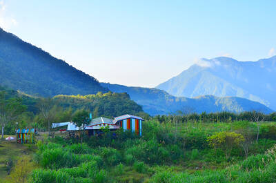
The area is also known for its odorless, sodium bicarbonate hot springs. We headed to Great Roots Forestry Spa and Resort (板根山森林遊樂園, NT$450 on weekdays and NT$550 on weekends), about 40 minutes drive up a winding road from Jiaobanshan, and had an enjoyable soak in their public pool.
The place is massive. In addition to the standard facilities and restaurants, it boasts a prehistoric animal exhibit, tea museum and will soon have a bronze museum.
There are a few forest trails within the resort grounds that contain several impressive “buttress root” trees that feature vertically compressed, plank-like roots. Unfortunately, the trail to the top of the hill was closed for renovation — another reason to visit again.
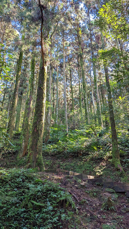
Photo: Han Cheung, Taipei Times
IF YOU GO
The fastest way to get to Jiaobanshan from Taipei is to drive. Taiwan Tourist Bus Travel Service (台灣好行) bus 502 runs on weekends and holidays from Taoyuan TRA station. On weekdays, take a bus from Taoyuan or Zhongli TRA stations to Daxi (大溪), where there are several bus options to Jiaobanshan and Dongyan Mountain. Weekend shuttles run between Great Roots Forestry Resort and Jingan and Yongning MRT stations.

Michael slides a sequin glove over the pop star’s tarnished legacy, shrouding Michael Jackson’s complications with a conventional biopic that, if you cover your ears, sounds great. Antoine Fuqua’s movie is sanctioned by Jackson’s estate and its producers include the estate’s executors. So it is, by its nature, a narrow, authorized perspective on Jackson. The film ends before the flood of allegations of sexual abuse of children, or Jackson’s own acknowledgment of sleeping alongside kids. Jackson and his estate have long maintained his innocence. In his only criminal trial, in 2005, Jackson was acquitted. Michael doesn’t even subtly nod to these facts.

The March/April volume of Foreign Affairs, long a purveyor of pro-China pablum, offered up another irksome Beijing-speak on the issues and solutions for the problems vexing the People’s Republic of China (PRC) and the US: “America and China at the Edge of Ruin: A Last Chance to Step Back From the Brink” rang the provocative title, by David M. Lampton and Wang Jisi (王緝思). If one ever wants to describe what went wrong with US-PRC relations, the career of Wang Jisi is a good place to start. Wang has extensive experience in the US and the West. He was a visiting

The January 2028 presidential election is already stirring to life. In seven or eight months, the primary season will kick into high gear following this November’s local elections. By this point next year, we will likely know the Democratic Progressive Party (DPP) candidate and whether the Taiwan People’s Party (TPP) will be fielding a candidate. Also around this time, the Chinese Nationalist Party (KMT) will either have already completed their primary, or it will be heading into the final stretch. By next summer, the presidential race will be in high gear. The big question is who will be the KMT’s
If one asks Taiwanese why house prices are so high or why the nation is so built up or why certain policies cannot be carried out, one common answer is that “Taiwan is too small.” This is actually true, though not in the way people think. The National Property Administration (NPA), responsible for tracking and managing the government’s real estate assets, maintains statistics on how much land the government owns. As of the end of last year, land for official use constituted 293,655 hectares, for public use 1,732,513 hectares, for non-public use 216,972 hectares and for state enterprises 34 hectares, yielding