For decades the simple act of walking was largely overlooked by city planners but, no matter how you choose to get around your city, chances are that you are a pedestrian at some point during the day.
Recently, some cities have made great strides: from the ambitious public squares programs of New York and Paris to the pedestrianization of major streets (realized in the case of Stroget in Copenhagen; proposed in the case of London’s Oxford Street and Madrid’s Gran Via.)
Jeff Speck’s grandly titled General Theory of Walkability states that a journey on foot should satisfy four main conditions: be useful, safe, comfortable and interesting.
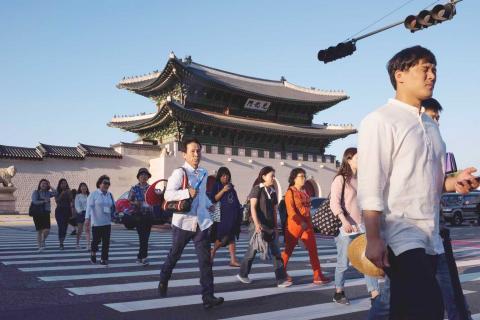
Photo: AFP
In his book Walkable City: How Downtown Can Save America, One Step at a Time, he argues that the “fabric” of the city — the variety of buildings, frontages and open spaces — is key.
US, Canadian and Australian cities, which were built for cars, have the challenge of retrofitting walking infrastructure.
Older European cities, which were built with walking in mind, have good fabric. This can make them walkable even if they lack pavements, crossings and other infrastructure for pedestrians — as is the case in Rome, says Speck.
“Rome, at first glance, seems horribly inhospitable to pedestrians,” he says. “Half the streets are missing sidewalks, most intersections lack crossings, pavements are uneven and rutted, disabled ramps are largely absent.”
Yet despite all this, as well as its hills and famously aggressive driving, this “anarchic obstacle course is somehow a magnet for walkers.” Why? Because Rome’s fabric is superb.
A NEW CITY RANKING
Walk Score, which lets prospective renters and buyers choose homes based on walkability, ranks cities in the US, Canada and Australia. New York tops the US list for this year at an overall 89 out of 100, with Little Italy and Union Square scoring full marks. San Francisco ranked second, followed by Boston. Vancouver, Toronto and Montreal rank from first to third respectively in Canada; while Australia’s most walkable cities are Sydney, Melbourne and Adelaide.
New York famously began its urban transformation program in 2007, its flagship scheme the part-pedestrianization of Times Square two years later. The former transportation commissioner for New York City, Janette Sadik-Khan, said: “We changed the city from places people wanted to park to places people wanted to be — street space to seat space.”
“On 23rd St, where three streets meet, we created 6,000 square meters of public space. People choose to sit on the street rather than the park,” she said.
Like most transportation experts, Sadik-Khan believes walkability is about more than safety — it is about economic competitiveness, too.
According to the UN, well-planned cities should have 30 percent to 35 percent of their land dedicated to streets to get the benefits of high connectivity.
Manhattan scores 36 percent.
New York City is far from perfect, scoring third worst in an Inrix analysis of congestion from 1,064 cities in 38 countries, with commuters spending on average 89.4 hours a year stuck in traffic. But what was achieved in the city — first in showcase projects built quickly and with cheap materials like paint, benches and planters — opened people’s eyes to what was possible.
Sadik-Khan now works with city mayors around the world via NACTO (the US National Association of City Transportation Officials), recently publishing a tactical urbanism manual, Street Fight: Handbook for an Urban Revolution, to help other planners learn from her experience.
NACTO and Sadik-Khan’s work on the “Paris Pietons” program clearly draws a lot on New York’s example. By 2020, seven city squares will be redesigned, giving 50 percent more space to those on bike and on foot. The Place de la Republique was transformed from a roundabout back to a square in 2013.
“Opponents said it would be chaos, but it is not the case,” says Paris’ deputy mayor for transport, Christophe Najdovski.
“It is now a place where people can rest, where families with children and older people can come,” he says.
Under the “Paris-Plages” scheme, a former road space on the Seine and La Villette canal basin is turned into a “seaside” resort each summer.
Since the city first banned cars from parts of the Right Bank in 2002, the seasonal festival has expanded each year, and is now on both banks of the river.
Paris was made for walking, but cars have taken over, Najdovski says.
“You can walk from one end of Paris to the other in less than two hours,” he adds, “but historically the city had to adapt itself to cars.” The result: pollution and congestion. Now, walking is a “principal policy.”
In the words of Jan Gehl: “Life happens on foot. Man was created to walk, and all of life’s events large and small develop when we walk among other people. There is so much more to walking than walking. There is direct contact between people and the surrounding community, fresh air, time outdoors...”
ONE FOOT IN FRONT OF THE OTHER
Cities around the world are taking steps. Madrid introduced water fountains to help pedestrians cope with the hot summers. Medellin, in Columbia, built cable cars to link up poor neighborhoods with employment centers, introduced library parks and widened its pavements to encourage walking. Melbourne, in Australia, transformed unloved alleyways used primarily for rubbish into its now famous “laneways” buzzing outdoor seating for coffee shops and restaurants.
Guangzhou, in China, has among the highest levels of walking in the world.
Redevelopment of the banks of the Pearl river to create an ecological corridor has connected six paths, resulting in 96km of greenways, linking tourist attractions and sporting venues serving seven million people.
In May, Seoul opened its own version of New York’s High Line. Seoullo 7017 — an almost kilometer-long “sky garden” created from a 1970s motorway flyover — is the latest step in a bold plan to transform the city for pedestrians.
A decade earlier, the city’s Cheonggyecheon freeway, another four-lane elevated road, was torn down, and the dirty creek beneath reopened to the sky, its riverbanks to walkers.
London is moving forward too, with the proposed transformation of Oxford Street, where pedestrians have been crammed on to narrow pavements between queues of buses for decades. Next year, the street will become what Val Shawcross, the deputy mayor for transport, calls a “world-class pedestrian space,” with buses and taxis banished. The idea is to route buses to the street, rather than through it, as part of a project to cut traffic and encourage walking and cycling in the area, ahead of the Crossrail opening at the end of next year.
Some cities, like Dallas and Beijing, are going backwards, according to Mario Alves from the International Federation of Pedestrians.
As well as cities where a conscious effort has been made to improve conditions for people on foot, some cities are walkable because of their historic centers. There’s Florence in Italy, Vientiane in Laos, Kyoto in Japan — but the most striking is perhaps Fes el Bali, a walled section of Fez, Morocco’s second largest city.
Founded in the 9th century, it is believed to be the world’s biggest car-free zone, and its medieval streets are so narrow that rubbish is still collected by donkey. The beauty of the city, in terms of walkability, is its density: 156,000 residents live in an area just 3.5 square kilometers. As a result, almost all trips are by foot — and children can play on the streets.
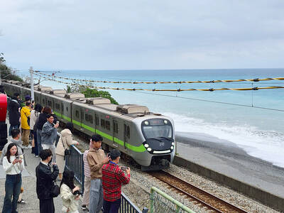
The small platform at Duoliang Train Station in Taitung County’s Taimali Township (太麻里) served villagers from 1992 to 2006, but was eventually shut down due to lack of use. Just 10 years later, the abandoned train station had become widely known as the most beautiful station in Taiwan, and visitors were so frequent that the village had to start restricting traffic. Nowadays, Duoliang Village (多良) is known as a bit of a tourist trap, with a mandatory, albeit modest, admission fee of NT$10 giving access to a crowded lane of vendors with a mediocre view of the ocean and the trains

For many people, Bilingual Nation 2030 begins and ends in the classroom. Since the policy was launched in 2018, the debate has centered on students, teachers and the pressure placed on schools. Yet the policy was never solely about English education. The government’s official plan also calls for bilingualization in Taiwan’s government services, laws and regulations, and living environment. The goal is to make Taiwan more inclusive and accessible to international enterprises and talent and better prepared for global economic and trade conditions. After eight years, that grand vision is due for a pulse check. RULES THAT CAN BE READ For Harper Chen (陳虹宇), an adviser
Traditionally, indigenous people in Taiwan’s mountains practice swidden cultivation, or “slash and burn” agriculture, a practice common in human history. According to a 2016 research article in the International Journal of Environmental Sustainability, among the Atayal people, this began with a search for suitable forested slopeland. The trees are burnt for fertilizer and the land cleared of stones. The stones and wood are then piled up to make fences, while both dead and standing trees are retained on the plot. The fences are used to grow climbing crops like squash and beans. The plot itself supports farming for three years.

President William Lai (賴清德) on Nov. 25 last year announced in a Washington Post op-ed that “my government will introduce a historic US$40 billion supplementary defense budget, an investment that underscores our commitment to defending Taiwan’s democracy.” Lai promised “significant new arms acquisitions from the United States” and to “invest in cutting-edge technologies and expand Taiwan’s defense industrial base,” to “bolster deterrence by inserting greater costs and uncertainties into Beijing’s decision-making on the use of force.” Announcing it in the Washington Post was a strategic gamble, both geopolitically and domestically, with Taiwan’s international credibility at stake. But Lai’s message was exactly