Major heat waves across southern Europe have pushed temperatures above 40°C in countries including Italy, Spain and Greece, as local authorities issued fresh warnings against the risk of wildfires.
Experts link the rising frequency and intensity of these heatwaves to climate change, warning that such extreme weather events are becoming increasingly common across Europe’s southern region.
Severe heat waves were recorded in Italy, Greece, Spain and Portugal before the weekend, with locals and tourists alike taking shelter from the sweltering conditions.

Photo: EPA-EFE
Two-thirds of Portugal were on high alert yesterday for extreme heat, with temperatures expected to top 42°C in Lisbon.
In Italy, a few regions — Lazio, Tuscany, Calabria, Puglia and Umbria — were planning to ban some outdoor work activities during the hottest hours of the day in response to the record-high temperatures. Italian trade unions pushed the government to expand such measures to a national level.
The Italian Ministry of Health yesterday placed 21 out of 27 monitored cities under its highest heat alert, including holiday destinations such as Rome, Milan and Naples.
In Rome, tourists tried to seek shade near popular spots like the Colosseum and Trevi Fountain, using umbrellas and drinking from public water fountains to stay cool.
Similar scenes were reported in Milan and Naples, where street vendors sold lemonade to tourists and residents to offer some refreshment from the heat.
Greece was again on high wildfire alert because of extreme weather.
A large wildfire broke out south of Athens on Thursday, forcing evacuations and road closures near the ancient Temple of Poseidon. Strong winds spread the flames, damaging homes and sending smoke across the sky.
Greek authorities deployed 130 firefighters, 12 planes and 12 helicopters to battle the blaze, while police evacuated 40 people, with five areas under evacuation orders.
In Spain, locals and tourists were desperately trying to keep cool over the weekend, as the country sizzled in temperatures as high as 42°C in the southern city of Seville along with other locations in southern and central parts of the country.
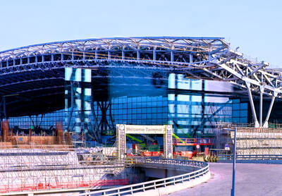
‘NO SECURITY RISK’: The Railway Bureau reassured the public that the technicians’ activities were limited to technical guidance and did not involve sensitive systems The Railway Bureau yesterday said it had invited eight Chinese technicians to assist with an airport MRT construction project. The bureau issued the confirmation after an Internet user said Chinese nationals had entered the construction zone of Taiwan Taoyuan International Airport’s Terminal 3 project. They asked why “individuals from an enemy state” were allowed access to such a major national infrastructure project, which raised serious concerns over Taiwan’s industrial safety, sensitive systems and information security. The bureau’s Northern Region Engineering Branch Office said subcontractor Taiwan Handle Industrial Co (台灣手把工業) of the Taoyuan airport MRT’s “Contract No. CU05 Project A14 Station Civil, MEP &
A US uncrewed surface vessel (USV) encountered multiple Chinese warships during an autonomous transit of the Taiwan Strait, US defense company Seasats said in a statement on Wednesday. Seasats announced that a Lightfish USV had completed the first autonomous transit of the Taiwan Strait. Over five days, the USV traversed the entire length of the Strait while constantly monitoring surface vessel traffic, the company said. The Lightfish encountered multiple Chinese warships, one of which was a Chinese People’s Liberation Army Navy (PLAN) Type 056 corvette, it said. The Chinese vessels were operating “well within Taiwan’s exclusive economic zone without transmitting their identity via the
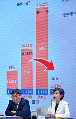
GREATER REACH? Auto parts and wood products would face tariffs of up to 15%, matching those targeting the EU, Japan and South Korea, Vice Premier said The US has announced that preferential tariff treatment for Taiwan’s non-semiconductor Section 232 goods would take effect retroactively from May 1, the Executive Yuan said yesterday. The US government yesterday posted a notice on the Federal Register’s public inspection Web site previewing tariff concessions for Taiwan under a memorandum of understanding (MOU) on Taiwan-US investment after two months of negotiations. The MOU signed on Jan. 15 stipulated three major preferential tariff arrangements: a 15 percent “reciprocal” tariff rate for Taiwan without stacking most-favored nation (MFN) rates; preferential Section 232 treatment for semiconductors and related products; and preferential Section 232 treatment for non-semiconductor
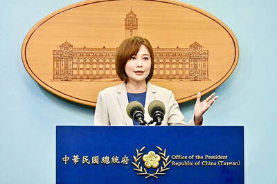
TIT-FOR-TAT: The US allegedly revoked the visa of a Chinese national working at Xinhua News Agency in the US in response to Beijing’s expulsion of Vivian Wang The Presidential Office yesterday condemned China for expelling a New York Times correspondent from Beijing following the newspaper’s interview with President William Lai (賴清德), saying the move highlighted Beijing’s suppression of press freedom and its threat to international news media. Taiwan has noted a series of recent incidents in which Beijing used similar tactics to “threaten and pressure international media outlets and journalists,” Presidential Office spokeswoman Karen Kuo (郭雅慧) said in a statement. “This concerns not only press freedom and freedom of expression, but also the safety of journalists, and Taiwan and relevant partners are paying close attention to the situation,” she