A US military transport plane made a brief stopover yesterday morning in Taipei, drawing media attention and no comment from the American Institute in Taiwan (AIT) or the Ministry of Foreign Affairs.
A C-146A Wolfhound touched down at Taipei International Airport (Songshan airport) at 9:32am after flying from Kadena Air Force Base in Okinawa, Japan, Television Broadcasts Satellite (TVBS) reported.
Apart from regular landing procedures handled by the airport, the air force said that it had no contact with the aircraft.
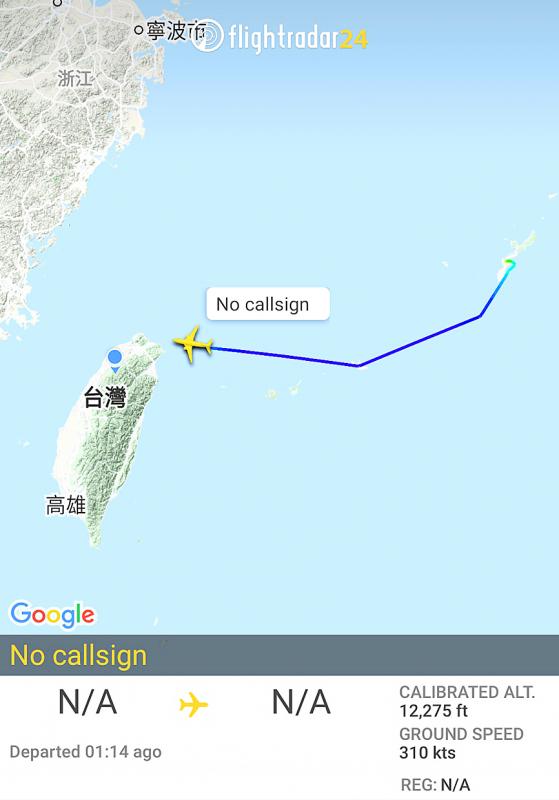
Photo: Screen grab from Twitter
It was reportedly carrying a package for newly installed AIT Director Sandra Oudkirk, who is undergoing a 14-day quarantine after arriving in Taiwan on Monday, TVBS said.
Originally scheduled to stay for one hour, the plane departed 24 minutes early at 10:06am after delivering the package, it reported.
The US Air Force says that the C-146A Wolfhound is a modified version of the Dornier 328 commuter airliner used mostly to transport small teams and cargo for the US Special Operations Command.
Chinese Ministry of National Defense spokesman Colonel Wu Qian (吳謙) expressed “grave concern” over the visit, saying that any foreign military aircraft landing on Chinese territory must be approved by the People’s Republic of China.
The US must cease playing with fire, as it would only draw Taiwan into a dangerous situation, Wu said in a statement on the ministry’s Web site.
“The Chinese People’s Liberation Army is on high alert and will take all necessary measures to resolutely crush any designs on ‘Taiwanese independence,’” he added.
China’s Taiwan Affairs Office (TAO) spokeswoman Zhu Fenglian (朱鳳蓮) urged the US to abide by the Three Joint Communiques and stop further provocative action.
Democratic Progressive Party Legislator Wang Ting-yu (王定宇), who serves on the legislature’s National Defense and Foreign Affairs Committee, confirmed the visit on Facebook, but declined to comment on its intent.
Regardless of what the aircraft came to do, its significance lies in the fact of its arrival, Wang said.
How the US interacts with Taiwan “is our business,” he said.
“No one else has the right to intervene,” Wang added.
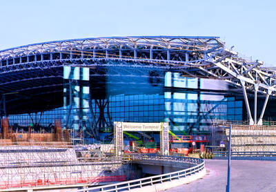
‘NO SECURITY RISK’: The Railway Bureau reassured the public that the technicians’ activities were limited to technical guidance and did not involve sensitive systems The Railway Bureau yesterday said it had invited eight Chinese technicians to assist with an airport MRT construction project. The bureau issued the confirmation after an Internet user said Chinese nationals had entered the construction zone of Taiwan Taoyuan International Airport’s Terminal 3 project. They asked why “individuals from an enemy state” were allowed access to such a major national infrastructure project, which raised serious concerns over Taiwan’s industrial safety, sensitive systems and information security. The bureau’s Northern Region Engineering Branch Office said subcontractor Taiwan Handle Industrial Co (台灣手把工業) of the Taoyuan airport MRT’s “Contract No. CU05 Project A14 Station Civil, MEP &
A US uncrewed surface vessel (USV) encountered multiple Chinese warships during an autonomous transit of the Taiwan Strait, US defense company Seasats said in a statement on Wednesday. Seasats announced that a Lightfish USV had completed the first autonomous transit of the Taiwan Strait. Over five days, the USV traversed the entire length of the Strait while constantly monitoring surface vessel traffic, the company said. The Lightfish encountered multiple Chinese warships, one of which was a Chinese People’s Liberation Army Navy (PLAN) Type 056 corvette, it said. The Chinese vessels were operating “well within Taiwan’s exclusive economic zone without transmitting their identity via the
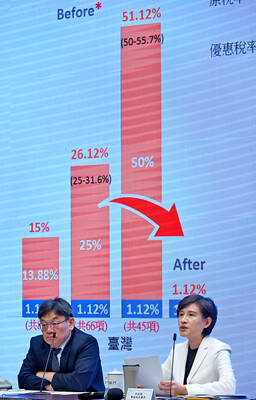
GREATER REACH? Auto parts and wood products would face tariffs of up to 15%, matching those targeting the EU, Japan and South Korea, Vice Premier said The US has announced that preferential tariff treatment for Taiwan’s non-semiconductor Section 232 goods would take effect retroactively from May 1, the Executive Yuan said yesterday. The US government yesterday posted a notice on the Federal Register’s public inspection Web site previewing tariff concessions for Taiwan under a memorandum of understanding (MOU) on Taiwan-US investment after two months of negotiations. The MOU signed on Jan. 15 stipulated three major preferential tariff arrangements: a 15 percent “reciprocal” tariff rate for Taiwan without stacking most-favored nation (MFN) rates; preferential Section 232 treatment for semiconductors and related products; and preferential Section 232 treatment for non-semiconductor
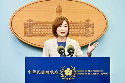
TIT-FOR-TAT: The US allegedly revoked the visa of a Chinese national working at Xinhua News Agency in the US in response to Beijing’s expulsion of Vivian Wang The Presidential Office yesterday condemned China for expelling a New York Times correspondent from Beijing following the newspaper’s interview with President William Lai (賴清德), saying the move highlighted Beijing’s suppression of press freedom and its threat to international news media. Taiwan has noted a series of recent incidents in which Beijing used similar tactics to “threaten and pressure international media outlets and journalists,” Presidential Office spokeswoman Karen Kuo (郭雅慧) said in a statement. “This concerns not only press freedom and freedom of expression, but also the safety of journalists, and Taiwan and relevant partners are paying close attention to the situation,” she