When the weather is too cold to enjoy the white beaches and blue waters of Pingtung County’s Kenting (墾丁), it’s the perfect time to head up into the hills and enjoy a different part of the national park. In the highlands above the bustling beach resorts, a simple set of trails treats visitors to lush forest, rocky peaks, billowing grassland and a spectacular bird’s-eye view of the coast.
The rolling hills beyond Hengchun Township (恆春) in Pingtung County offer a two-hour through-hike of sweeping views from the mighty peak of Dajianshih Mountain (大尖石山) to Eluanbi Lighthouse (鵝鑾鼻燈塔) on the coast, or ambitious hikers can complete the six-hour “Hengchun grand trail” (恆春大縱走) finishing in Kenting’s cattle ranches.
The hike starts in the hills behind a temple just east of Hengchun town center. Yucyuan Temple (玉泉寺), labeled as “Yuquan Temple” on Google Maps, has bathrooms and plenty of parking, not to mention a view of the town and plains around it.
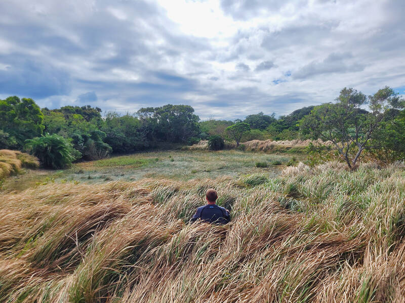
Photo: Tyler Cottenie
The path leading away from the temple winds its way through shady banyan forest, rich with the smell of lowland tropical forest. As the trail climbs very gently upward, the forest starts to give way to open grassland, dry and golden brown during the windy winter season. The gently rolling terrain is a pleasant change from the steep uphills so common among Taiwan’s trails, and the thorny screw pines bordering the grassland have been cut far back from the trail, no longer a nuisance.
A sign in Chinese marks the location of a former Japanese military encampment, though any signs of the camp have long been overgrown by vegetation. Further up the trail, a crude bomb shelter was dug into the side of a hill and has remained intact to this day.
HIGH AMONG THE HILLS
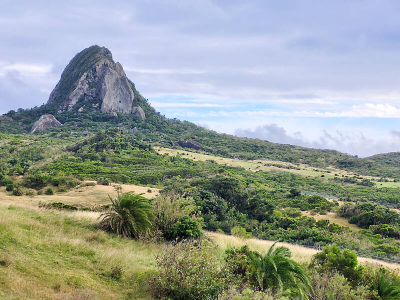
Photo: Tyler Cottenie
As the trail crests the next hill, there is a sweeping view of Hengchun town center and the high-voltage transmission towers dotting the hills of the Central Mountain Range to the north, carrying electricity away from Kenting’s still-operational nuclear power plant. For only 250 meters in elevation, the view is superb. Abandoned concrete military buildings nearby offer a view of the remainder of the hike to the east. The iconic Dajianshih Mountain juts up into the sky like a Taiwanese Matterhorn, and the ridge above the Pacific coast is visible in the far distance.
The next stop is the much less rugged hill in the foreground, Dashanmu Mountain (大山母山). About one more hour of walking is enough to reach the summit. The trail continues to be surprisingly pleasant, with sweeping views, gentle slopes and alternating forest and grassland. The trail passes a signed junction 772 meters before the peak. To the right, an unmarked path leads down to the coast at Nanwan (南灣) and can serve as an exit for hikers after summiting Dashanmu Mountain, which is still straight ahead.
Be careful on the trail after this point, as there are ruts from off-road motorcycles. On the day we hiked, several motorcycles drove by us along this section. They had started from the road between Hengchun and Manjhou Township (滿州) to the north. Close to the summit, the motorcycle path continues to the left around the mountain; hikers should take the right fork straight up to the summit.
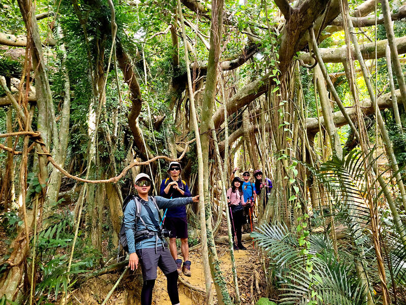
Photo: Tyler Cottenie
Dashanmu Mountain (大山母山) was added to Taiwan’s Small 100 Peaks (小百岳) in 2017, turning it into a very popular destination. The downside is that the trail is now quite busy — we shared the summit with about a dozen others on a Saturday — but the upside is that the trail to get here is in much better condition now.
From the summit at 325 meters, the Kenting coastline is visible, from the town itself all the way to the Eluanbi Lighthouse, a small white pillar on Taiwan’s southernmost peninsula. Rounding out the view in the foreground is the impressive Dajianshih Mountain.
For some people, this is far enough for one day. A trail leading south from the summit descends toward Nanwan, eventually connecting with the other path down to Nanwan mentioned above. This is a convenient way to complete a through-hike, as there are plenty of buses down at Nanwan to take you back to Hengchun.
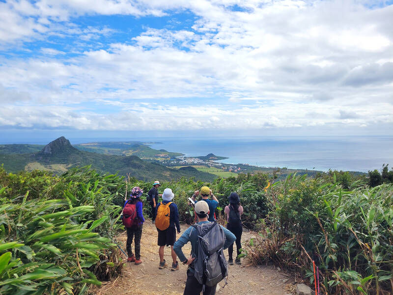
Photo: Tyler Cottenie
However, if this two-hour hike isn’t enough for you, keep hiking to complete what is unofficially being called the “Hengchun grand trail,” similar to the Taipei Grand Trail (台北大縱走).
ROCKS AND RANCHES
Backtrack from the summit less than a minute and turn right at the fork. This trail is well-marked and descends all the way to the Shihniou River (石牛溪). So close to the source, it’s little more than a trickle between stagnant puddles, so you won’t even get your feet wet walking along the riverbed.
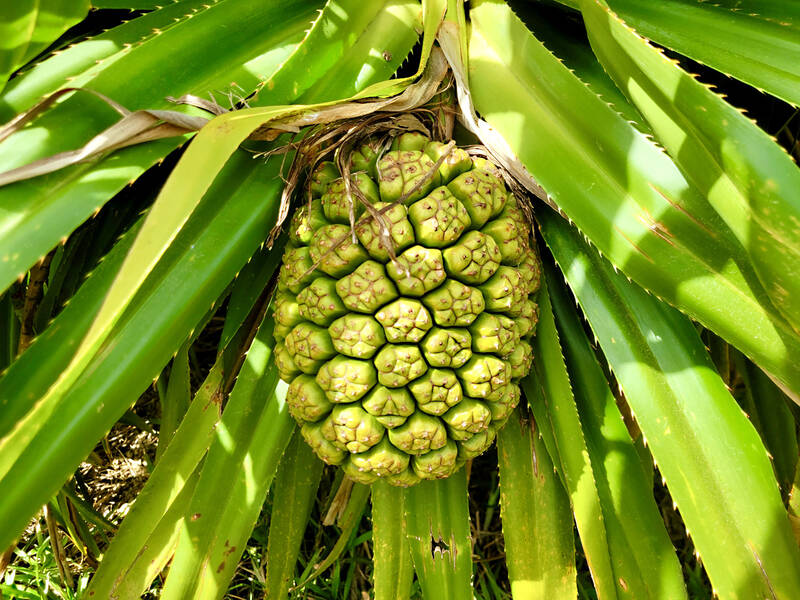
Photo: Tyler Cottenie
Head downstream a few minutes until you see ribbons on the left, and then continue following the ribbons uphill. The trail soon reaches the base of Siaojianshih Mountain (小尖石山). Up close, this peak is quite striking: a large, bare, fractured rock jutting up into the sky. Cursory exploration through thick, pointy vegetation indicates that it’s possible — though not very enjoyable — to get close to the top, but summiting its vertical face is likely beyond the ability of an ordinary hiker.
After passing around the base of Siaojianshih Mountain, Kenting’s ranch land and cattle come into view. This vast stretch of grassland has been fenced off within the last year and access to the ranch road formerly used by hikers is now cut off. It’s still possible to head east along the fence and follow the trail down to Yongjing Village (永靖村) on the Hengchun-to-Manjhou road, completing your through-hike near a bus stop for an easy return to Hengchun.
It’s also possible to follow the outside of the fence southbound. There is now a clear footpath right up against the fence for about 700 meters until it finally crosses a farm road, which you can then follow the rest of the way down. This is closest to the original grand trail route, and the most scenic way to end your through-hike, as the ranch land and cattle are nearby, and you get closer and closer to Dajianshih Mountain and the ocean throughout the descent.
After the final gate, you will reach an asphalt road where you may have left a vehicle before the hike. If you don’t have this luxury, it is a 1.5-kilometer walk out to the main road where you can catch a bus back to Hengchun. The entire Hengchun grand trail should have taken you about six hours.

US President Donald Trump may have hoped for an impromptu talk with his old friend Kim Jong-un during a recent trip to Asia, but analysts say the increasingly emboldened North Korean despot had few good reasons to join the photo-op. Trump sent repeated overtures to Kim during his barnstorming tour of Asia, saying he was “100 percent” open to a meeting and even bucking decades of US policy by conceding that North Korea was “sort of a nuclear power.” But Pyongyang kept mum on the invitation, instead firing off missiles and sending its foreign minister to Russia and Belarus, with whom it
When Taiwan was battered by storms this summer, the only crumb of comfort I could take was knowing that some advice I’d drafted several weeks earlier had been correct. Regarding the Southern Cross-Island Highway (南橫公路), a spectacular high-elevation route connecting Taiwan’s southwest with the country’s southeast, I’d written: “The precarious existence of this road cannot be overstated; those hoping to drive or ride all the way across should have a backup plan.” As this article was going to press, the middle section of the highway, between Meishankou (梅山口) in Kaohsiung and Siangyang (向陽) in Taitung County, was still closed to outsiders

Many people noticed the flood of pro-China propaganda across a number of venues in recent weeks that looks like a coordinated assault on US Taiwan policy. It does look like an effort intended to influence the US before the meeting between US President Donald Trump and Chinese dictator Xi Jinping (習近平) over the weekend. Jennifer Kavanagh’s piece in the New York Times in September appears to be the opening strike of the current campaign. She followed up last week in the Lowy Interpreter, blaming the US for causing the PRC to escalate in the Philippines and Taiwan, saying that as

The Chinese Communist Party (CCP) has a dystopian, radical and dangerous conception of itself. Few are aware of this very fundamental difference between how they view power and how the rest of the world does. Even those of us who have lived in China sometimes fall back into the trap of viewing it through the lens of the power relationships common throughout the rest of the world, instead of understanding the CCP as it conceives of itself. Broadly speaking, the concepts of the people, race, culture, civilization, nation, government and religion are separate, though often overlapping and intertwined. A government