The Mountains to Sea National Greenway (山海圳國家綠道) draws its name from the idea that each hiker starting at the summit of Jade Mountain (玉山) and following the trail to the coast is like a single raindrop. Together, many raindrops form life and prosperity-bringing waterways.
Replicating a raindrop’s journey holds poetic beauty, but all hikers know that climbing is infinitely more appealing, and so this installment picks up where the last one left off — heading inland and uphill along the 49.8-kilometer Canal Trail (大圳之路) — second of the Greenway’s four sections. A detailed map of the trail can be found here.
HISTORIC IRRIGATION SYSTEM
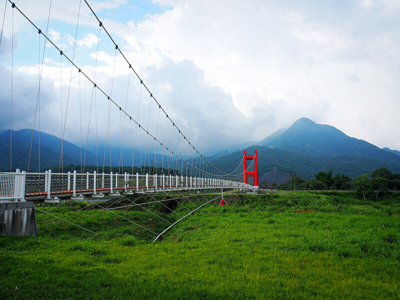
Photo: Ami Barnes
From the Chianan Plain (嘉南平原) to the reservoir-side of Dapu District (大埔) via bikeways, backroads and footpaths — every part of this section is accompanied by the spirit of Yoichi Hatta, a Japanese engineer whose almost century-old irrigation system still supplies the plains with water.
In total, his team constructed 1,300 kilometers of main channels and 3,850 kilometers of subsidiary channels that spill capillary-like across the land, transforming formerly flood-prone plains into fertile farmland for water-hungry crops like rice and water caltrops.
Striking a north-northeasterly course from Tainan’s Shanhua District (善化), the trail hews close to Chianan Irrigation Canal’s Southern Main Line (嘉南大圳南幹線).
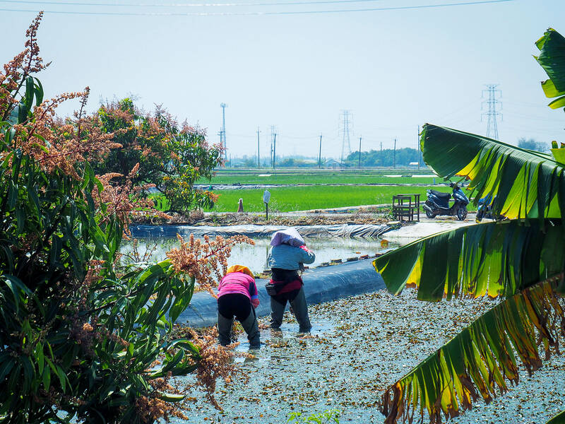
Photo: Ami Barnes
Where necessary, aqueducts convey the water on its coastward course — noteworthy among them, Zengwen River Aqueduct (曾文溪渡槽橋).
When it entered service in 1929, water flowed through a boxlike channel across the 339-meter span, while foot traffic and vehicles passed on a paved upper level. The aqueduct has been superseded by two new bridges, but visitors still can observe a cross-section of this original structure.
Continuing along the cycle path, the waterway expands in increments until it becomes a broad arterial channel.

Photo: Ami Barnes
The source of this channel is Wushantou Reservoir (烏山頭水庫). Nicknamed Coral Lake on account of the shape made by tongues of water that reach deep into the folds of surrounding hills, the reservoir came into existence when Hatta’s team built a 1,273m-long dam across Guantian River (官田溪).
A third Greenway trail stamp is held at the reservoir’s ticket booth, and the nearby Hatta Yoichi Memorial Park (八田與一紀念園區) is home to careful reconstructions of Japanese-style buildings that Hatta and his family occupied while working on the irrigation project.
Leaving the reservoir, the Greenway skirts Liujia District (六甲). As the last built-up area before Dapu Borough, it is a good point to stop and gather provisions, and if tackling the journey on foot, it’s also a logical place to spend the night.
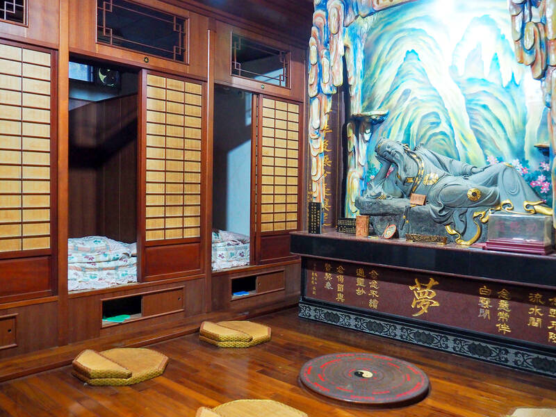
Photo: Ami Barnes
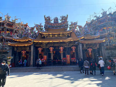
OVERNIGHT STAY
By far the most unique place to stay is Liujia’s Zhennan Temple (六甲鎮南宮). Guests can spend the night in an altar-side room where Lu Dongbin (呂洞賓) — Taoist deity and one of the Eight Immortals of Chinese mythology fame — is said to provide in-dream spiritual guidance. To book a room, which costs NT$600, call (06) 698-2464.
Locals and visitors gather in front of the temple in the evening to drink and chat, but be warned, the caffeine content of the temple custodian’s tea will forestall any chance of sleep — or indeed a nighttime celestial visitation.
From Liujia, the trail follows kilometer after kilometer of farming roads. Bamboo and orchards coat the slopes, and during a March visit, the scent of orange blossom perfumed the air.
Next stop is Xikou Xiao Ruishi (西口小瑞士, or Xikou Little Switzerland). The area’s distinguishing feature is a gaping-mouthed whirlpool spillway through which excess water gets funneled — as depicted in the design of the fourth Greenway stamp.
Heading on from the watery scenery, walkers’ calves will be tested by the Greenway’s first proper climb — a steep single-lane road winding through the longan orchards of Beizao (焙灶).
Much of the crop will be picked, packed and shipped fresh to markets around Taiwan, but the area has a scattering of traditional smoke-drying kilns that are pressed into service each summer.
The process is labor-intensive. For several days, farmers must babysit their harvest, flipping it twice daily and regularly tending the fires. The result is a distinctive smoky-sweet dried fruit that’s often added to soups and drinks.
HISTORIC TRAIL
Orchards bear the trail up to Wushan Ridge (烏山嶺) where walkers will find themselves following Wushanling Water Conservancy Historic Trail (烏山嶺水利古道) — so named because it follows the route taken by Hatta and his surveyors as they planned the Wushanling Diversion Tunnel.
Driving a 3,078-meter-long tunnel straight through the side of a hill in an area with no power supply was perhaps the most ambitious element of Hatta’s plans, and unsurprisingly, the seven-year construction period was beset by challenges.
Storms meant the purpose-laid handcar tracks for transporting machinery were abandoned in favor of rafts. A hydropower station had to be built to provide electric lighting. Even the area’s geology conspired to make the project harder with its lethal pockets of oil and gas.
Despite these setbacks, Hatta’s tunnel was completed and served for 90 years before the construction of New Wushanling Diversion Tunnel saw it relegated to backup.
Descending towards Zengwen River, the trail emerges at Dongkou Workstation (東口工作站), beside the tunnel’s eastern intake, then turns left to track upstream through Zengwen Reservoir Scenic Area (曾文水庫風景區).
For those attempting a through-hike, it would make sense to pause here, spending the night at Zengwen Youth Activity Center (曾文青年活動中心). Rooms are NT$2,025 per night and can be booked by calling: (06) 575-3431.
Pressing onwards, the route heads for Zengwen Dam. Views of Zengwen Reservoir can be enjoyed by gazing eastwards from atop the dam, while downstream, a trio of spillway channels stretch to meet the river valley.
Construction of the reservoir and dam — part of Hatta’s plans — was shelved when World War II broke out and wasn’t completed until the 1970s.
QUIET ROADS TO DAPU
From the dam, it’s a long walk along quiet roads to Dapu. A fifth trail stamp resides in Dapu Visitor Information Station (大埔旅遊資訊站), along with displays explaining why — thanks to typhoons and driftwood — Dapu is home to Taiwan’s violin industry.
Across town, is Qiedong Old Street (茄苳老街). When Zengwen Reservoir was created, Qiedong was one of several settlements in its flood zone.
Residents had to choose between relocating to distant, suboptimal plots of land allocated by the government or receiving a subsidy to sort things out by themselves.
They opted for the subsidy. Together, they deconstructed the bamboo buildings pole by pole, panel by panel and carried them up to where they sit today.
Dapu has plenty of hotels and restaurants, making it the ideal place to rest and recuperate before launching into the trail’s third section — the Tribal Trail.

If a leisurely afternoon of high-end dining and watching the scenery roll by from the comfort of a plush armchair sounds like a good time to you, consider a trip on the Sea Breeze (海風號). This culinary, cultural and scenic experience is the perfect setting for a date, a celebratory outing with a small group of friends or a relaxing solo ride. The price tag is steep, especially if you consider the short distance the train actually covers over the 3.5-hour journey. But what you’re paying for on the Sea Breeze isn’t transportation; it’s the comfort, the service, the exclusivity, the
Audiences in Leicester, Cardiff, London and Sheffield will this month gather to watch a series of black-and-white Taiwanese-language films made more than 70 years ago. On the surface, these screenings commemorate the seventieth anniversary of taiyupian (台語片) — Taiwanese-language cinema. Yet the significance of these events extends far beyond nostalgia or film history. They represent a remarkable chapter in Taiwan’s ongoing effort to recover, preserve and reinterpret a cultural heritage that was once thought to have largely disappeared. The centerpiece of the program is the Ho Chi-ming (何基明) directed Xue Pinggui and Wang Baochuan (薛平貴與王寶釧), a film produced in 1955 and
In December of 2008 Lee E-tin (李乙廷), a Miaoli county legislative hopeful, was convicted of vote-buying. Rather than buy votes retail, voter by voter, in the usual manner, Lee had done it wholesale, in a commendably efficient manner: he had visited local temples and made donations to gain their support. Because he did not normally make donations to temples, the court ruled he was attempting to improperly influence voter behavior. The case indicates how important temples are in influencing political life. Both judge and politician appeared to see them in the same way. Beijing sees them that way as well. Democratic Progressive

One of the wildest things about the reception of Chinese Nationalist Party (KMT) Chair Cheng Li-wun (鄭麗文) in the international media is the way her words are presented without being contextualized, let alone challenged. The Financial Times, for example, interviewing her during her visit to New York, said that she blamed the halt to exchanges between Taiwan and the People’s Republic of China (PRC) for raising tensions. “There has been no dialogue, so you can see that the situation is almost on the brink of war,” the Financial Times quoted her as saying, without any hint that the PRC, not