Chiayi County has more than it’s fair share of short hiking routes, and working through the list is a personal priority. Earlier this week, I spent a day driving to and hiking along the Youth Ridge Trail (青年嶺環狀步道), a path so named because, in its original form, its steepness is said to have left all but youngsters utterly exhausted.
Like many of the tracks that criss-cross Taiwan’s mountains, the Youth Ridge Trail was first blazed by indigenous villagers so they could trade with nearby communities. The path as it now exists is a shortcut of sorts between two points on Road 166. If you can’t persuade someone to drop you at one of these locations and pick you up at the other, you might have to do what I did — park, hike to the far end, then retrace your steps back to your vehicle.
The trail is 2.385km long*, and contour maps suggest that one-way hikers might prefer to start at the northern end near Rueili Elementary School (瑞里國小). That trailhead, at the 78.7 mark on Road 166, is a little over 1,000m above sea level.
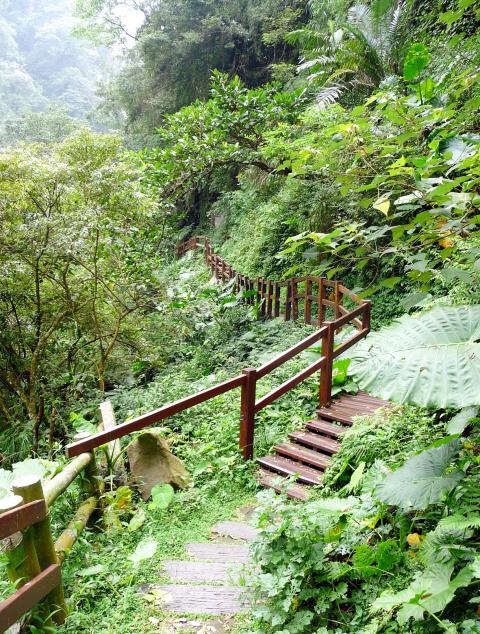
Photo: Steven Crook
To shorten the time I spent behind the wheel, I turned off Road 166 at the 72.2km mark. A steep downward side-road very quickly leads to the trail’s southern terminus at an altitude of approximately 850m. Finding a convenient spot to park my car was easy. On weekends, it’s likely to be much more difficult.
As I was about to set foot on the path — the entrance is marked with an informative bilingual mapboard — I noticed that an attractive butterfly had taken a liking to my car. A few minutes later, I disturbed a large cluster of lepidopterans, among which was the largest non-birdwing butterfly I’ve ever seen. I got fairly close to it before it flew off in a blur of yellow and pale orange. Its wingspan was around 15cm.
After a few switchbacks through bamboo, the trail entered mixed forest. Dozens of tiny, dark orthopterans jumped off the path; they looked like grasshoppers to me, but I’m no expert. I got fed up with wiping spiders’ webs off my face, so, as I progressed northward and lower toward Cujhihkeng Creek (粗紙坑溪), I took to waving a short stick at head height.
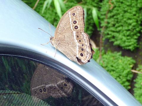
Photo: Steven Crook
The creek is certainly deep enough to drown in, but there’s no obvious way to get down to its rocky banks. Just before the Lovers Suspension Bridge (情人吊橋), 865m from the southern trailhead, I looked across the narrow valley and got my first proper view of the Youth Ridge Trail’s most famous sight: Swallow Cliff (燕子崖). Unless the weather has been dry for weeks, you’ll see a curtain of water pouring out of the forest above the cliff, and crashing down onto a huge, smooth boulder.
The horizontal ridges in the cliff face were caused by wind erosion. During spring and summertime, they’re inhabited by nesting swallows .
Less than 100m further on, what’s called the Bat Cave (蝙蝠洞) isn’t a cave but another cliff face. The rock here is pockmarked by irregular holes. Some looked large enough to conceal my water bottle, but I didn’t investigate too closely, in case there were bats inside. According to an information board, bat numbers here have declined due to human disturbance.
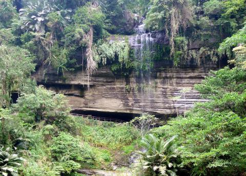
Photo: Steven Crook
A few hundred meters further along, I came to a rest area with a bench and a sign that told me I was now 1,020m from Rueili Elementary School. I didn’t immediately realize it, but this marked the start of Heroes Slope (好漢坡), the stretch of trail which is said to separate the weak from the strong.
As befits its reputation, the slope was unrelenting. The contour map shows a gain of nearly 300m in that 1.02km, and I felt every meter. Nowadays, almost all of the ascent is on elevated wooden stairways, so at least there’s no risk of slipping on mud.
On Heroes Slope, there are several breaks in the tree cover. The views can be good, but during my hike visibility was limited by low cloud. A bit later, as I worked my way back down the slope on the return leg of my hike, I could hear the chugging and horn-blasting of a train on the Alishan Forest Railway (阿里山森林鐵路). The nearest station on the logging line is Jiaoliping (交力坪).
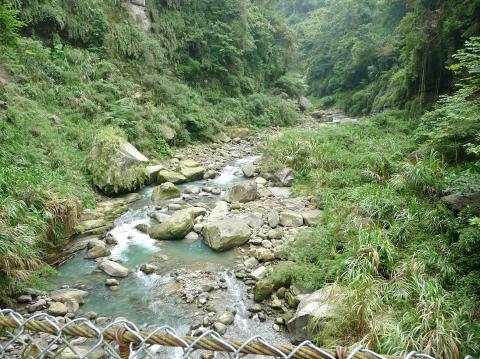
Photo: Steven Crook
According to bloggers, finishing the trail takes most people at least an hour and a half. Including photo stops, a 20-minute break for my lunch of bread and tuna, and a few other pauses to catch my breath, I completed my there-and-back hike in three and a half hours. Not bad for a 50-year-old — but as I write this, nearly 48 hours later, my calf muscles have yet to recover.
* An earlier version of this story incorrectly stated that the "trail is at the the 2.385km mark." It should have said that the "trail is 2.385km long." The Taipei Times regrets the error.
Steven Crook has been writing about travel, culture, and business in Taiwan since 1996. He is the co-author of A Culinary History of Taipei: Beyond Pork and Ponlai, and author of Taiwan: The Bradt Travel Guide, the third edition of which has just been published.
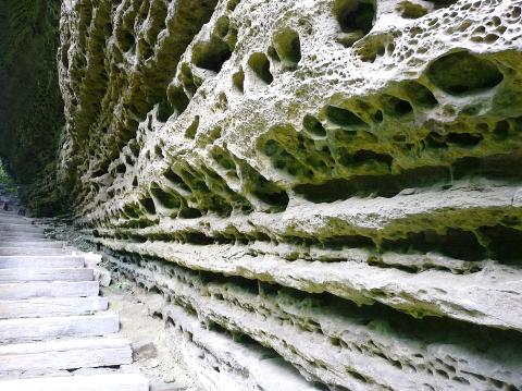
Photo: Steven Crook

Growing up in a rural, religious community in western Canada, Kyle McCarthy loved hockey, but once he came out at 19, he quit, convinced being openly gay and an active player was untenable. So the 32-year-old says he is “very surprised” by the runaway success of Heated Rivalry, a Canadian-made series about the romance between two closeted gay players in a sport that has historically made gay men feel unwelcome. Ben Baby, the 43-year-old commissioner of the Toronto Gay Hockey Association (TGHA), calls the success of the show — which has catapulted its young lead actors to stardom -- “shocking,” and says

The 2018 nine-in-one local elections were a wild ride that no one saw coming. Entering that year, the Chinese Nationalist Party (KMT) was demoralized and in disarray — and fearing an existential crisis. By the end of the year, the party was riding high and swept most of the country in a landslide, including toppling the Democratic Progressive Party (DPP) in their Kaohsiung stronghold. Could something like that happen again on the DPP side in this year’s nine-in-one elections? The short answer is not exactly; the conditions were very specific. However, it does illustrate how swiftly every assumption early in an

Inside an ordinary-looking townhouse on a narrow road in central Kaohsiung, Tsai A-li (蔡阿李) raised her three children alone for 15 years. As far as the children knew, their father was away working in the US. They were kept in the dark for as long as possible by their mother, for the truth was perhaps too sad and unjust for their young minds to bear. The family home of White Terror victim Ko Chi-hua (柯旗化) is now open to the public. Admission is free and it is just a short walk from the Kaohsiung train station. Walk two blocks south along Jhongshan
Francis William White, an Englishman who late in the 1860s served as Commissioner of the Imperial Customs Service in Tainan, published the tale of a jaunt he took one winter in 1868: A visit to the interior of south Formosa (1870). White’s journey took him into the mountains, where he mused on the difficult terrain and the ease with which his little group could be ambushed in the crags and dense vegetation. At one point he stays at the house of a local near a stream on the border of indigenous territory: “Their matchlocks, which were kept in excellent order,