Nov. 26 to Dec. 2
The Tsou people called it Patungkuanu, which the Qing officials directly translated into Batongguan (八通關). The Japanese called it Niitakayama, or “New High Mountain,” after discovering that it was taller than Mount Fuji. And Westerners called it Mount Morrison, after the captain who sighted it when setting out from Anping (安平) in today’s Tainan.
Today, it’s known as Yushan, or Jade Mountain — and has been since Dec. 1, 1947. The Chinese Nationalist Party (KMT) was quick to eradicate Taiwan of Japanese names after World War II, and Niitakayama reverted to its Qing Dynasty name.
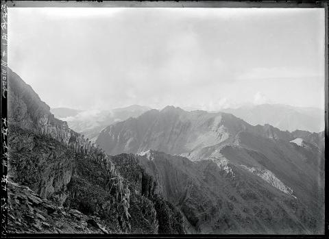
Photo courtesy of National Taiwan Museum
The following passage is found in a Qing record from 1685, just two years after the empire annexed Taiwan: “When the weather is fair, it looks like a white stone from afar. That is why it is called Jade Mountain.”
HOLY MOUNTAIN
Jade Mountain was not the only name that appeared in Qing annals; there was also White Jade Mountain (白玉山) and Snow Mountain (雪山).
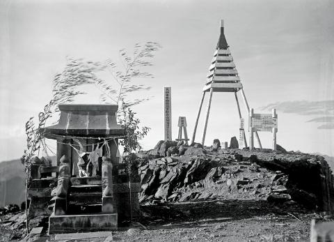
Photo courtesy of Fang Chin-chin
For most of the Qing Dynasty it was still uncharted Aboriginal territory, with an 1805 report describing the inhabitants as “savages that appear from nowhere, taking the heads of every person they see. Most people stay away from this area out of fear.”
By 1874, however, the Qing changed their policy of separating Aborigines and Han Chinese, and started building roads up the mountain.
Yushan has long been sacred to both Bunun and Tsou Aborigines. The mountain appears in many legends from both groups as a refuge to a great flood, which turned the peak into an island. In many versions, the waters receded after a crab defeated a giant snake or eel that was clogging up a major river. The Kanakanavu people have almost the same legend except it was a pig who defeated the snake/eel.
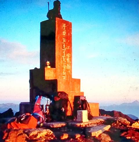
Photo courtesy of Yushan National Park Headquarters
The Tsou and Bunun also share tales of Yushan being the source of fire, which they sent a Taiwanese blue magpie to retrieve, giving the bird its reddish beak color. The species of the bird varies by story.
Li Yi-ching (李怡靜) writes in the study The Aborigine in the Legends of Yushan (玉山傳說中的原住民) that the main difference between the two peoples is that the Tsou believe they were created on the top of Yushan while the Bunun originated further to the west and only moved to Yushan after the flood.
Yushan remains a source of legends until this day. For example, many believe in a demon wearing a yellow raincoat that appears near Yushan’s south peak, giving hikers directions that will lead them off a cliff.
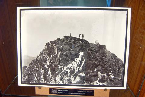
Photo: Chen Hsin-jen, Taipei Times
‘NEW HIGH MOUNTAIN’
Even though the Qing didn’t cede Taiwan to the Japanese until 1895, Shiga Shigetaka’s Theory of Japanese Landscape, published in 1894, already included Taiwan and referred to the mountain as “Taiwan’s Fuji.”
According to the book Yushan History (玉山史話) by Lin Wen-chun (林玟君), it was such a huge deal for the Japanese to discover that Yushan was higher than Fuji, that the Meiji Emperor personally gave it the name Niitakayama on June 28, 1897. The official edict refers to the mountain’s previous name as “Mount Morrison.”
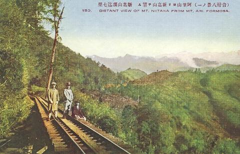
Photo courtesy of Wikimedia Commons
For the first few years of Japanese rule, there was much variation between the names of Yushan’s many peaks. The current designations of north, east, south, west and main peaks were standardized around 1904.
The exact height of Yushan also varied during the early Japanese era, ranging from 3,900 meters to 4,300 meters. Using new technology, the Japanese settled on 3,950 in 1925 — just two meters less than its official height today.
Niitaka became a popular name for places, ships, stores and businesses in Taiwan. Lin writes that when the Japanese government coded their orders for the bombing of Pearl Harbor as “Climb Niitakayama 1208,” with the number referring to the attack date (Japan time, as it was still Dec. 7 in Hawaii).
DECAPITATION ON MAIN PEAK
In the few years following Japanese defeat, the mountain was still referred to as “Xingaoshan,” the Mandarin pronunciation of Niitakayama, but eventually “Yushan” took over.
Instead of using Japanese measurements, Taiwanese officials went with the 3,997 meters surveyed by the US Army Forces Far East in 1957. This gave rise to the idea of building a 3-meter statue of the late Control Yuan President Yu You-ren (于右任) to reach 4,000 meters.
Before Yu died in 1964, he wrote a poem expressing his longing for his homeland of China: “Bury me on a high mountain so I can gaze toward my homeland; although I can never see it again, I will never forget it!”
The statue, facing west toward China, was unveiled in 1967 to a crowd of about 80 hikers chanting “Long Live President Chiang” (蔣介石).
As the KMT’s authoritarian rule waned in the 1980s, hikers began defacing the statue, sparking a debate on whether to keep or remove it. With the matter unresolved, a group cut off the statue’s head in 1995, but the park authorities retrieved and reattached it.
A year later, the entire statue was removed and thrown into a ravine, never to be found again. It was quickly replaced by the large stone which hikers pose with today.
Taiwan in Time, a column about Taiwan’s history that is published every Sunday, spotlights important or interesting events around the nation that have anniversaries this week.
What was the population of Taiwan when the first Negritos arrived? In 500BC? The 1st century? The 18th? These questions are important, because they can contextualize the number of babies born last month, 6,523, to all the people on Taiwan, indigenous and colonial alike. That figure represents a year on year drop of 3,884 babies, prefiguring total births under 90,000 for the year. It also represents the 26th straight month of deaths exceeding births. Why isn’t this a bigger crisis? Because we don’t experience it. Instead, what we experience is a growing and more diverse population. POPULATION What is Taiwan’s actual population?
For the past five years, Sammy Jou (周祥敏) has climbed Kinmen’s highest peak, Taiwu Mountain (太武山) at 6am before heading to work. In the winter, it’s dark when he sets out but even at this hour, other climbers are already coming down the mountain. All of this is a big change from Jou’s childhood during the Martial Law period, when the military requisitioned the mountain for strategic purposes and most of it was off-limits. Back then, only two mountain trails were open, and they were open only during special occasions, such as for prayers to one’s ancestors during Lunar New Year.

You would never believe Yancheng District (鹽埕) used to be a salt field. Today, it is a bustling, artsy, Kowloon-ish “old town” of Kaohsiung — full of neon lights, small shops, scooters and street food. Two hundred years ago, before Japanese occupiers developed a shipping powerhouse around it, Yancheng was a flat triangle where seawater was captured and dried to collect salt. This is what local art galleries are revealing during the first edition of the Yancheng Arts Festival. Shen Yu-rung (沈裕融), the main curator, says: “We chose the connection with salt as a theme. The ocean is still very near, just a
A key feature of Taiwan’s environmental impact assessments (EIA) is that they seldom stop projects, especially once the project has passed its second stage EIA review (the original Suhua Highway proposal, killed after passing the second stage review, seems to be the lone exception). Mingjian Township (名間鄉) in Nantou County has been the site of rising public anger over the proposed construction of a waste incinerator in an important agricultural area. The township is a key producer of tea (over 40 percent of the island’s production), ginger and turmeric. The incinerator project is currently in its second stage EIA. The incinerator