As the boat sped towards Turtle Island on my last visit, it was wearing its “hat,” a neat cushion of cloud that made the island look even more mysterious, rising out of a steely gray sea. However, as we approached, the hat disappeared, the summit of the island (400m above us) materialized and the sun broke through the thinning clouds, so we could enjoy both the impressive cliffs and rock formations, and the powder-blue waters around the turtle’s “head” at their colorful best.
Rising out of the Pacific Ocean off the coast of Yilan County, Turtle Island (龜山島) was off-limits to the public for 23 years until it opened to permit-carrying tourists in 2000, and for a long time it was one of Taiwan’s most mysterious places. About 3.3km long by 1.7km wide, the island rises to 398m and at the foot of its very steep northern slopes lie two brackish, fish-filled lakes and a pair of springs, one cold, the other (on the seabed, just offshore) hot.
Turtle Island is a relatively young landform, created, our guide said, about 7,000 years ago from two volcanoes, which rose from the ocean floor. Over the course of at least four eruptions, they merged to form the distinctive shape of the island — two highlands divided by a low-lying “neck.”
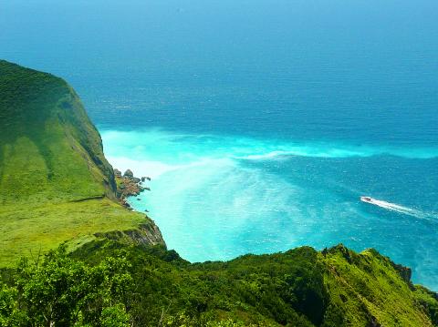
Photo: Richard Saunders
Unless you can secure a permit to climb the trail to the island’s summit, the highlight of a visit is that amazing coastline. Luckily, all tours of the island do a complete circle, so there’s time to gape at the awesome cliffs.
Next to the harbor, at the western tip of the island, is one of its most unusual sights — the turtle’s “tail,” a narrow bar of shingle about a kilometer long that curves out into the ocean. Beyond lie the awesome cliffs of the island’s southern and eastern coasts. The most impressive section is around the turtle’s “head,” where after swooping low to the gracefully curved neck, the land rises steeply once more to end abruptly at its most dramatic cliffs. At their base, a large area of ocean has been tinted a striking powder-blue color, caused by the extraordinary underwater hot springs oozing up from the seabed.
After a circuit of the island, non-landing tours head off into the open ocean for a spot of what boat operators rather optimistically call “whale watching.” The surrounding ocean is rich in fish, which thrive on nutrients swept off the seabed by the Kuroshio Current, coming up from the south. Feeding on these in turn are whales and dolphins: the best time for spotting them is between May and August, when the current is at its strongest.
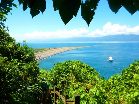
Photo: Richard Saunders
Spinner dolphins, bottle-nosed dolphins, small killer whales and false killer whales have been seen, although realistically, whale sightings are rare, you may well see dolphins. Flying fish are common in these waters during their annual summer migration north along the eastern shore of Taiwan, when they can often be seen skimming above the water for improbable distances, especially around June.
Tours that do feature a landing dock at the island’s little harbor. Tours all have a guide, who naturally wields a noisy megaphone, and although groups are supposed to stay with them, it’s worth trying to lag behind the tight cluster of tourists hanging onto every amplified word, and see the area at your own leisure.
Near the harbor is the island’s visitor center (with simple food and cold drinks) and a small, colorful temple, which stands on the shores of the larger of the two lakes. The area around the expanse of brackish water is the only flat land on Turtle Island and the only place where fresh water can be found, thanks to the cold spring on its bank. This was the area settled when fishermen began arriving on the island in 1853.
Photo: Richard Saunders
By 1967 Turtle Island’s population had swollen to 750, and the village even had a school. In 1977 the inhabitants were all relocated to Taiwan’s mainland when the army turned the island into a restricted military zone. The impressive series of tunnels bored into the cliff at the far end of the lake date from this time. They end at a series of gun emplacements which offer wonderful views over the ocean. The one huge gun still on site here points — a bit disconcertingly — not out to sea but directly towards mainland Taiwan.
Paths leading to the tunnels circle the lake, one passing a large, white statue of Guanyin sheltering under the steep, overgrown slopes of the interior, and the other passing through the remains of the abandoned village; several of the half-ruined buildings now house exhibitions of old photos dating back to when the island was inhabited by civilians.
Richard Saunders is a classical pianist and writer who has lived in Taiwan since 1993. He’s the founder of a local hiking group, Taipei Hikers, and is the author of six books about Taiwan, including Taiwan 101 and Taipei Escapes. Visit his Web site at www.taiwanoffthebeatentrack.com.
Photo: Richard Saunders
If one asks Taiwanese why house prices are so high or why the nation is so built up or why certain policies cannot be carried out, one common answer is that “Taiwan is too small.” This is actually true, though not in the way people think. The National Property Administration (NPA), responsible for tracking and managing the government’s real estate assets, maintains statistics on how much land the government owns. As of the end of last year, land for official use constituted 293,655 hectares, for public use 1,732,513 hectares, for non-public use 216,972 hectares and for state enterprises 34 hectares, yielding
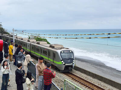
The small platform at Duoliang Train Station in Taitung County’s Taimali Township (太麻里) served villagers from 1992 to 2006, but was eventually shut down due to lack of use. Just 10 years later, the abandoned train station had become widely known as the most beautiful station in Taiwan, and visitors were so frequent that the village had to start restricting traffic. Nowadays, Duoliang Village (多良) is known as a bit of a tourist trap, with a mandatory, albeit modest, admission fee of NT$10 giving access to a crowded lane of vendors with a mediocre view of the ocean and the trains

For many people, Bilingual Nation 2030 begins and ends in the classroom. Since the policy was launched in 2018, the debate has centered on students, teachers and the pressure placed on schools. Yet the policy was never solely about English education. The government’s official plan also calls for bilingualization in Taiwan’s government services, laws and regulations, and living environment. The goal is to make Taiwan more inclusive and accessible to international enterprises and talent and better prepared for global economic and trade conditions. After eight years, that grand vision is due for a pulse check. RULES THAT CAN BE READ For Harper Chen (陳虹宇), an adviser
Traditionally, indigenous people in Taiwan’s mountains practice swidden cultivation, or “slash and burn” agriculture, a practice common in human history. According to a 2016 research article in the International Journal of Environmental Sustainability, among the Atayal people, this began with a search for suitable forested slopeland. The trees are burnt for fertilizer and the land cleared of stones. The stones and wood are then piled up to make fences, while both dead and standing trees are retained on the plot. The fences are used to grow climbing crops like squash and beans. The plot itself supports farming for three years.