The Ministry of Transportation and Communications' Institute of Transportation said yesterday that it has developed a software application that allows motorists to identify dangerous road sections around the nation using Google Earth.
Google Earth displays three-dimensional overviews of major cities, mountains and other terrain, as well as the location of local businesses and other information all over the world.
Isaac Chen (
People would also like to be informed of roads that are unsafe for pedestrians, but previously there was no way of providing such information, he said.
Chen said the software uses Google Earth to map out the different locations where traffic accidents have occurred in the past. In the meantime, the software will help display detailed information of each accident next to that specific site, from the death toll and injuries to the cause of the accident.
The software would help both motorists and pedestrians pilot a safer route, he said.
It would also help highway and legal authorities find solutions to reducing traffic accidents in each section.
Chen said that at the initial stage the software would only be available to government organizations within a year. The software may be available to the public without charge in the future, he said.
NATIONAL SECURITY: Authorities are working to confirm the identities of the military personnel involved and investigating possible illegal conduct and regulatory violations Authorities are probing possible national security implications after Kinmen police and immigration officers on Sunday found a Chinese woman allegedly posing as a tourist while engaging in prostitution involving more than 10 military personnel. The woman, surnamed Chen (陳), has since been deported, authorities said, adding that investigators are still working to confirm the identities of those implicated, as the records only listed code names and aliases. The case stemmed from a report received by the Kinmen District Prosecutors’ Office on Friday last week from the Jinhu Precinct of the Kinmen County Police Bureau. On Sunday, police, along with the National Immigration

GLOBALGIVING: ‘ Caving to external pressure is not acceptable for an organization that has cultivated justice reform and human rights for 30 years,’ one NGO said A slew of non-government organizations (NGOs) have withdrawn from the GlobalGiving fundraising platform after it announced it would use “Chinese Taipei” instead of “Taiwan” from next month. The Taiwan Good Rice Association wrote on Facebook on Friday that it was informed on April 28 via a teleconference call of the change, which was made because the platform wanted to operate in China. Taiwan Good Rice is to terminate all cooperative relationships with GlobalGiving in response to the platform’s “unilateral and non-negotiable” decision to remove references to Taiwan, the NGO said. “Taiwan is in the official name of Taiwan Good Rice Association and the
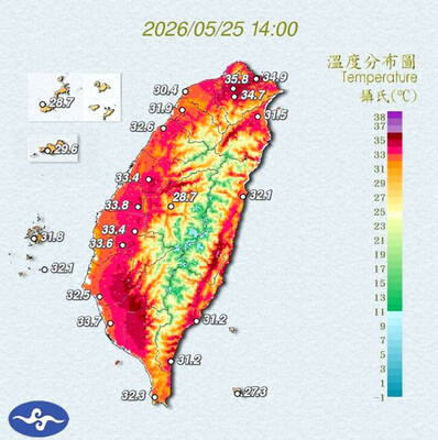
STAY COOL: The HPA recommended that people stay hydrated, use air-conditioning or fans while indoors, wear loose-fitting clothes and walk in the shade while outdoors Employers must implement measures such as installing cooling equipment, and providing drinking water and rest breaks for outdoor workers starting from Monday next week, the Taipei Department of Labor said on Sunday. Employers who fail to comply could face fines of NT$30,000 to NT$300,000 under the Occupational Safety and Health Act (職業安全衛生法), the department said. Businesses in Taipei employing fewer than 100 workers, as well as registered self-employed workers with labor insurance coverage, could receive on-site assessments and guidance from occupational safety consultants to help them apply for central government subsidies to implement or improve heat-protection measures, it said. Under the Ministry of

Chinese Nationalist Party (KMT) Chairwoman Cheng Li-wun (鄭麗文) yesterday briefed her party’s Central Standing Committee regarding her scheduled visit to the US between Monday next week and June 16, saying that her purpose would be to persuade the US that the Republic of China (ROC) Constitution was a “one China” constitution that would foster stable and peaceful cross-strait relations. The ROC Constitution is the most important defense for all Taiwanese citizens, as it upholds our democracy and has contributed to our robust economy, which aligns with international and US interests, she said. “We would not be troublemakers and drag the US under,”