The images taken by Taiwan’s first indigenously developed satellite, Formosat-5, has been used to calculate underwater topography and monitor rice production after it became commercially operational last year, and its performance is comparable to that of a US high-resolution satellite, the National Space Organization (NSPO) said yesterday.
The NSPO, a National Applied Research Laboratories affiliate, yesterday at a news conference in Taipei touted the academic applications of images taken by Formosat-5.
The optical remote sensing satellite was launched on Aug. 25, 2017, from Vandenberg Air Force Base in California on a Falcon 9 rocket built by Space Exploration Technologies Corp, commonly known as SpaceX.
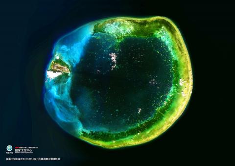
Photo courtesy of the National Space organization
It became commercially operational in September last year, and has been transmitting black-and-white images with a resolution of 2m and color images with a resolution of 4m.
Huang Chih-yuan (黃智遠), an associate professor at National Central University’s Center for Space and Remote Sensing Research, said that his team used the satellite images to map the underwater topography around the Pratas Islands (Dongsha Islands, 東沙) using an “artificial neural network” computing method.
Compared with WorldView-2, a commercial imaging satellite with better resolutions, Formosat-5 images only have a margin of error of up to 40cm, meaning the two perform similarly, he said.
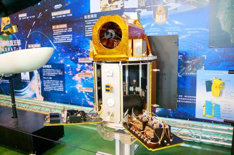
Photo: Chan Shih-hung, Taipei Times
Whether the difference matters depends on areas of application, he added.
While the satellite cannot take underwater images as deep as sonar equipment, it can save costs for in situ surveys of places where the topological relief is not that significant, he added.
Chu Tzu-how (朱子豪), a professor at National Taiwan University’s Spatial Information Research Center, said that his team used the satellite images to calculate the areas of rice fields in Taiwan, with an accuracy level of 90.05 percent.
The Agricultural Research Institute in August sparked controversy when it was found to have attempted to buy images sourced from a China-based firm for monitoring crop production.
Only China’s Zhuhai-1 remote sensing satellite constellation could satisfy the institute’s requirements for image resolution better than 10m with more than 30 wavebands, the institute said at the time.
Asked about the issue yesterday, Chu said that purchases of satellite images can be purely commercial transactions, avoiding confidential data.
Countries owning satellites also share information for disaster-relief purposes, he added.
While Formosat-5 has only four wavebands, they are sufficient for most agricultural survey missions, he said.
The NSPO is planning to launch 10 satellites from this year through 2028: six high-resolution satellites, two ultra-high-resolution satellites and two synthetic aperture radar satellites, NSPO Director-General Lin Chun-liang (林俊良) said.
It is also updating its integration and testing facilities for satellite instruments, and preparing standard specification guidelines for the manufacture of related components, Lin added.
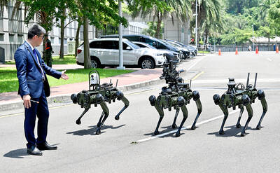
The National Chungshan Institute of Science and Technology yesterday showcased its locally developed variants of the Vision 60 robotic patrol dog, which it plans to deploy on the nation’s outlying territories in the South China Sea. The variants were produced under the Joint Lab project — created by the institute and domestic companies — and assembled with domestically produced motors, lenses and artificial intelligence (AI) systems alongside licensed tech from the US, Missile and Rocket Systems Research Division deputy director Jen Kuo-kang (任國光) told the media event at a military base in Taipei’s Dazhi (大直) area. Taiwan has built up its strengths

RIGHT DIRECTION: Taiwan’s efforts to prevent forced labor include a proposal to ‘fully prohibit’ employers from withholding workers’ documents, an official said Taiwan is to establish a mechanism to restrict imports of goods linked to forced labor, the Executive Yuan said yesterday, after the US proposed imposing additional tariffs on Taiwanese goods over labor concerns. “The Ministry of Labor and the Ministry of Economic Affairs are to establish an interministerial review procedure,” Executive Yuan spokesperson Michelle Lee (李慧芝) said at a news briefing in Taipei. “The government is to use the Foreign Trade Act [貿易法] as the legal basis to restrict imports of goods produced with forced labor” and bring its supply chain governance more in line with international standards on human rights, resilience
NOT IMMEDIATE: Taiwan has a chance to appeal the proposed 10 percent tariff before it starts, while other countries face a 12.5 percent tariff from the trade office Taiwan is among 60 economies determined by the US to have failed to impose or enforce a ban on the importation of goods produced with forced labor, according to a notice released on Tuesday by the Office of the US Trade Representative (USTR), which proposed imposing an additional 10 percent or more tariff on them. The USTR in a statement said that following an investigation, it had determined under Section 301 of the Trade Act of 1974 that the failure of the 60 economies to impose and effectively enforce a prohibition on the importation of goods produced with forced labor is
TIT-FOR-TAT: The US allegedly revoked the visa of a Chinese national working at Xinhua News Agency in the US in response to Beijing’s expulsion of Vivian Wang The Presidential Office yesterday condemned China for expelling a New York Times correspondent from Beijing following the newspaper’s interview with President William Lai (賴清德), saying the move highlighted Beijing’s suppression of press freedom and its threat to international news media. Taiwan has noted a series of recent incidents in which Beijing used similar tactics to “threaten and pressure international media outlets and journalists,” Presidential Office spokeswoman Karen Kuo (郭雅慧) said in a statement. “This concerns not only press freedom and freedom of expression, but also the safety of journalists, and Taiwan and relevant partners are paying close attention to the situation,” she