With the center and south of the nation still reeling from a tropical depression system that has hovered above Taiwan since Thursday, the combination of a monsoon trough and the southwest airstream is expected to bring more rain this week.
As of noon yesterday, the death toll from the flooding stood at seven, with 116 people injured and 599 people in shelters, statistics from the Central Emergency Operation Center showed.
Agricultural losses caused by the flooding are estimated to have reached at least NT$563.11 million (US$18.35 million) as of 5pm, while repairing damage to schools and other buildings is expected to cost NT$157 million, the center said.

Photo: Wang Han-ping, Taipei Times
From today to Wednesday, chances of showers or thundershowers would be high in the nation’s center, south and southeast, the Central Weather Bureau said, adding that torrential to extremely torrential rainfall is likely.
The rest of the nation could also expect showers or thundershowers, with the possibility of heavy rainfall, it said.
The weather would remain unstable for the next few days, the bureau said, adding that people should be alert for landslides and quickly rising river levels, especially in low-lying areas.
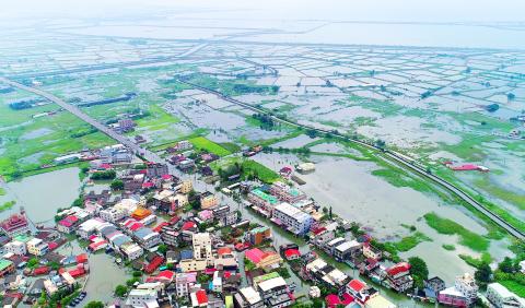
Photo courtesy of the Chiayi County Government
Due to the southwest airstream, coastal areas nationwide could see strong winds measuring level 8 to level 10 on the Beaufort scale, it said.
The extended forecast predicts rain will ease nationwide on Thursday and Friday, when a Pacific high-pressure system is expected to strengthen and the southwest airstream to weaken slightly, the bureau said.
However, chances of showers or thundershowers would remain high nationwide, it said.
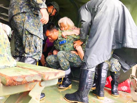
Photo: EPA-EFE
Former bureau Weather Forecast Center director Daniel Wu (吳德榮) said in his online blog that the tropical depression system that hovered above the nation last week arrived in China’s Hangzhou Bay yesterday, while the front end of the southwest airstream moved to the south of the Taiwan Strait and the Bashi Channel, which led to the increase of rain in Taitung and Pigtung counties.
Earlier in the day, the emergency center said that water levels were receding in the 1,222 flooded areas, with the exception of nine areas in Chiayi County and one in Tainan, where floodwaters were expected to drop later yesterday.
During a visit to the emergency center, Premier William Lai (賴清德) said the authorities and the public should begin disinfecting and sterilizing affected areas to prevent contagious diseases, and that farm animals that died in the flooding should be incinerated if necessary.
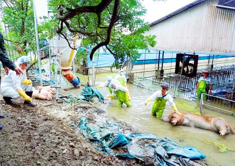
Photo: CNA
Lai gave the instruction after he was briefed by the Council of Agriculture on the number of farm animals that died in flooding in central and southern Taiwan.
About 1.4 million chickens, 500,000 ducks, 200,000 geese and 7,000 pigs reportedly died in the flooding, emergency center statistics showed as of noon.
The council should know the number of farms where livestock was affected, Lai said, adding that it should assist the Ministry of National Defense in removing the carcasses.
The council should replicate its experience with avian flu by placing the carcasses in sealed bags before sending them to incinerators, Lai said.
As dengue fever cases have been reported in Taichung, Taipei and New Taipei City, government agencies should disinfect areas affected by the floods to prevent the mosquito-borne disease from spreading, Lai said.
President Tsai Ing-wen (蔡英文) visited Chiayi County’s Budai Township (布袋) again yesterday for the second time in two days.
She promised to instruct water resource departments to address the flooding and reminded residents to take precautions against further rain.
Additional reporting by CNA

LEVERAGE: China did not ‘need to fire a shot’ to deny Taiwan airspace over Africa when it owns ‘half the continent’s debt,’ a US official said, calling it economic warfare The EU has raised concerns about overflight rights following the delay of President William Lai’s (賴清德) planned state visit to the Kingdom of Eswatini after three African nations denied overflight clearance for his charter at the last minute. Taiwanese allies Paraguay and Saint Kitts and Nevis, as well as several US lawmakers and the Inter-Parliamentary Alliance on China (IPAC) condemned China for allegedly pressuring the countries. Lai was scheduled to fly directly to Taiwan’s only African ally from yesterday to Sunday to celebrate the 40th anniversary of King Mswati III’s accession and his 58th birthday, but Seychelles, Mauritius and Madagascar suddenly revoked
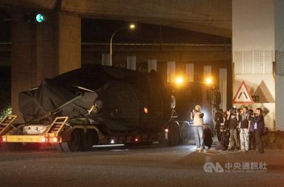
The final batch of 28 M1A2T Abrams tanks purchased from the US arrived at Taipei Port last night and were transported to the Armor Training Command in Hsinchu County’s Hukou Township (湖口), completing the military’s multi-year procurement of 108 of the tanks. Starting at 12:10am today, reporters observed more than a dozen civilian flatbed trailers departing from Taipei Port, each carrying an M1A2T tank covered with black waterproof tarps. Escorted by military vehicles, the convoy traveled via the West Coast Expressway to the Armor Training Command, with police implementing traffic control. The army operates about 1,000 tanks, including CM-11 Brave Tiger
China on Wednesday teased in a video an aircraft carrier that could be its fourth, and the first using nuclear power, while making an allusion to Taiwan and vowing to further build up its islands, as it looks to boost maritime power, secure resources and bolster territorial claims. The video, issued on the eve of the 77th founding anniversary of the Chinese People’s Liberation Army Navy, featured fictional officers with names that are homophones of three commissioned aircraft carriers, the Liaoning (遼寧), Shandong (山東) and Fujian (福建). Titled Into the Deep, it showed a 19-year-old named “Hejian” (何劍) joining the group, sparking

BIG YEAR: The company said it would also release its A12 chip the same year to keep a ‘reliable stream of new silicon technologies’ flowing to its customers Taiwan Semiconductor Manufacturing Co (TSMC, 台積電) yesterday said its newest A13 chip is to enter volume production in 2029 as the chipmaker seeks to hold onto its tech leadership and demand for next-generation chips used in artificial intelligence (AI), high-performance-computing (HPC) and mobile applications. TSMC, the world’s biggest contract chipmaker, also unveiled its A12 chip at its annual technology symposium in Santa Clara, California. The A12 chip, which features TSMC’s super-power-rail technology to provide backside power delivery for AI and HPC applications, is also to enter volume production in 2029, a year after the scheduled release of the A14 chip. The technology moves