Taroko Gorge (太魯閣峽谷) never fails to inspire awe with its majesty and incredible beauty. Perhaps Taiwan’s most famous tourist attraction, it’s worth a visit, even if only seen from the window of a car or coach traveling along the road carved through its depths. How much better though, if possible, to explore a little of it on foot on one of the 10 trails developed by Taroko National Park.
Most of these routes are for general tourists rather than committed hikers, but several are “real” hikes, and take hikers into parts of the gorge that no coach tour group will ever go. The longest, the Dali-Datong Trail (大禮大同步道), offers probably the most authentic Aboriginal experience in the gorge area, and some magnificent yet little-enjoyed scenery to boot.
Dali and Datong settlements aren’t in the gorge itself, but cling to the upper slopes of a side canyon, the Shakadang (砂卡礑) gorge. It’s possible to walk up to Dali (and, for very strong hikers, to Datong) and back to civilization in a long day, but with all the effort needed to get up there (including 800m in elevation gain) it’s better to do it as a two-day trip, and enjoy a night up on top.
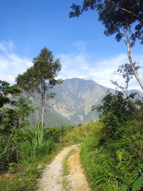
Photo: Richard Saunders
The Dali-Datong Trail made the national news last week after a 66-year-old Chinese woman walking along the short Shakadang Trail (砂卡礑步道) with a tour group left her companions and became lost. She ended up the following day, 21 hours later, on the Dali-Datong Trail, where she was helped back down by a rescue team.
HITTING THE TRAILS
The usual route up to Dali and Datong starts at the Taroko National Park Headquarters, at the eastern end of Taroko Gorge. Before you start the hike, pay a visit to the police station next door with your passport or Taiwan ID, and get a police permit. As long as the trail is open (you can check its status on the park’s English, Japanese and Chinese-language Web site: www.taroko.gov.tw), getting the permit is only a five-minute formality.
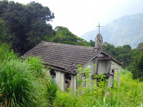
Photo: Richard Saunders
Walk up the steps from the large car park and turn left along the Taroko Terrace Trail (太魯閣台地步道), soon joining the dirt Dekalun Trail (得卡倫步道), which winds uphill in several lazy zigzags. Check out the lower station of the cableway (down a short, signposted trail on the left), via which logs harvested from the mountains high above were once brought down, and food and other essentials were (and probably still are) taken up the mountain to the villagers — the only way (other than on foot) to reach them.
In less than 10 minutes there’s a junction. The Dekalun Trail (straight on) climbs the mountainside on a raised wooden path via hundreds of steps. More interesting (although a lot more strenuous) is to turn left up a narrow dirt trail that climbs straight up the precipitous hillside beside a small, plastic water pipe. It’s extremely steep for the first fifteen minutes or so, with some awkward sections that require both hands and feet. Take care, especially if carrying a heavy backpack.
Eventually (over an hour above the Park Headquarters) the trail climbs to a large concrete platform: the middle station of the cableway. The view from the platform over the mouth of the Liwu River (立霧溪), the mountains beyond and (much less appealingly) the horrible gash of a huge quarry opposite, is spectacular. Beyond the cableway station, the trail becomes more straightforward, and soon re-joins the main Dekalun Trail for the final ascent to the top of the mountainside, the upper cableway station (which has a vertiginous view over the edge of the gorge) and the start of a length of road that connects Dali and Datong villages.
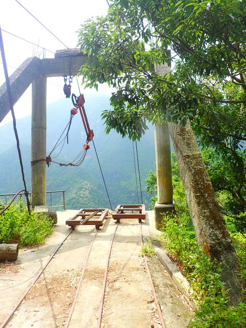
Photo: Richard Saunders
DATONG VILLAGE
The easiest way to Datong village is to follow the road (about two hours’ walk at a leisurely pace, including stops to enjoy the scenery). However, a more interesting way to Datong (which takes only a little longer, because, although much slower-going, it’s more direct) is to turn sharp left at the junction a few minutes along the road, downhill to a couple of ramshackle structures that are all that is left of the former community of Dali. If the weather is clear, look out for the scattered houses of Datong village, crowning a bluff a couple of kilometers further north up the gorge. Just below the path, a signpost points the way to the abandoned village church, an evocative little building slowly being swallowed by a sea of tall undergrowth.
The Dali-Datong Trail starts just beyond the church and soon becomes a dirt trail contouring the steep, wooded mountainside, crossing a series of small streams, their beds littered with beautiful chunks of rough marble. The trail up from Shakadang joins from the left about midway to Datong.
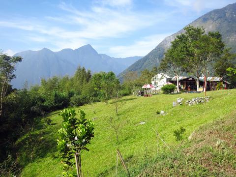
Photo: Richard Saunders
Datong consists of just four or five residences widely spread out on the grassy hillside, and commanding expansive views over the gorge of the Shakadang River, the rocky tip of Mount Qingshui (清水山; 2,408 meters) ahead, and, to its right and in front, the shapely dome of Mount Qianliyan (千里眼山; 1,624 meters).
It takes 5-6 hours to get here from the National Park Headquarters, so most hikers that make it this far stay the night, either in a villager’s house or camping on the grass (ask first). Try to book in advance (especially on Saturday nights) in case a hiking group is passing through, to avoid a very long, and possibly benighted, walk back down.
Once here, kick back, enjoy the amazing peace, listen to the residents speak Truku to each other, and (if the weather is clear) goggle at the stupendous views over the Shakadang River gorge and the big mountains opposite. Taroko Gorge may be just a few kilometers away as the eagle flies, but up here, it could just as well be a hundred.
Richard Saunders is a classical pianist and writer who has lived in Taiwan since 1993. He’s the founder of a local hiking group, Taipei Hikers, and is the author of six books about Taiwan, including Taiwan 101 and Taipei Escapes. Visit his Web site at www.taiwanoffthebeatentrack.com.

Taiwan’s English education system is being pulled apart by three opposing forces. Bilingual Nation 2030 pulls students toward English and global communication. Artificial Intelligence (AI) readiness pulls them toward digital judgment, verification and AI-mediated work. But Taiwan’s old exam culture pulls them back toward memorization, grammar drills, timed reading and correct answers. If the education system keeps using old exams to define success, it risks producing graduates who are neither genuinely bilingual nor genuinely AI-ready, but trained for tasks machines can already perform. The first force is Bilingual Nation 2030. Launched in 2018, the policy aimed to “help Taiwan’s workforce connect

“Taiwan’s Opposition Leader Comes to US With a Message Straight Out of Beijing” read a May 31 headline in the Wall Street Journal. Top US administration officials and members of Congress almost certainly read the WSJ, and if there was a bullet point takeaway that people in Washington should absorb ahead of Chinese Nationalist Party (KMT) Chair Cheng Li-wun’s (鄭麗文) arrival in DC on June 9, that headline is it. The last few columns have discussed this very topic, and the timing is not coincidental. While those top officials likely do not read the Taipei Times, judging by the number

With weighty, anxiety-inducing geopolitical topics dominating the headlines, checking in on the wild and weird state of local politics can take some of the edge off. This November’s elections will determine who will be in charge of fixing potholes in your neighborhood, not the potholes in Taiwan’s complicated geopolitical space. Recently, after an online interview with a Taipei-based journalist, I commented that Taipei journalists never go further than the MRT can take them. He laughed and agreed. Naturally, the Taipei mayoral race is eating up much of the press attention. TAIPEI CITY Democratic Progressive Party (DPP) candidate Puma Shen (沈伯洋) has
As someone who normally steers clear of books with “transcendence” or “metaphysics” in their subtitles, this reviewer — a casual observer of local belief systems since the 1990s — found Fabian Graham’s Money God Temples in Taiwan a challenging read. Those who’ve only dipped their toes into temple culture will likely need to parse several sections with special care if they’re to keep up with the author, a British ethnographic researcher whose previous books have investigated religious practices among ethnic Chinese in Southeast Asia. This scholarly volume examines a facet of Taiwan’s religious landscape that didn’t exist a century ago, and