There’s a curious consensus among many lovers of the Matsu islands that Dongyin (東引) is the most beautiful. With it’s easternmost peninsula, the famous Lienyu Yikeng Cliff (烈女義坑, also known as Suicide Cliff), stunningly situated lighthouse and extraordinary Yisiantian (一線天, also known as Thread of Sky), Dongyin has a lot on offer. Yet the island also has the heaviest remaining military presence of any in the Matsu group. Until nature is allowed to take over and soften many a cruel blemish and scar, visitors will have to ignore many eyesores en route to Dongyin’s scenic highlights.
On the frontline
Dongyin is connected with the neighboring island of Xiyin (西引) by a causeway, and while this sister islet is less visited, it has several natural and militaristic sights of great interest. Incidentally, the heavy military presence on both islands means it’s best to keep your ID on you while exploring — on my last visit it was still needed to visit a couple of the sights — and be careful where you point your camera.
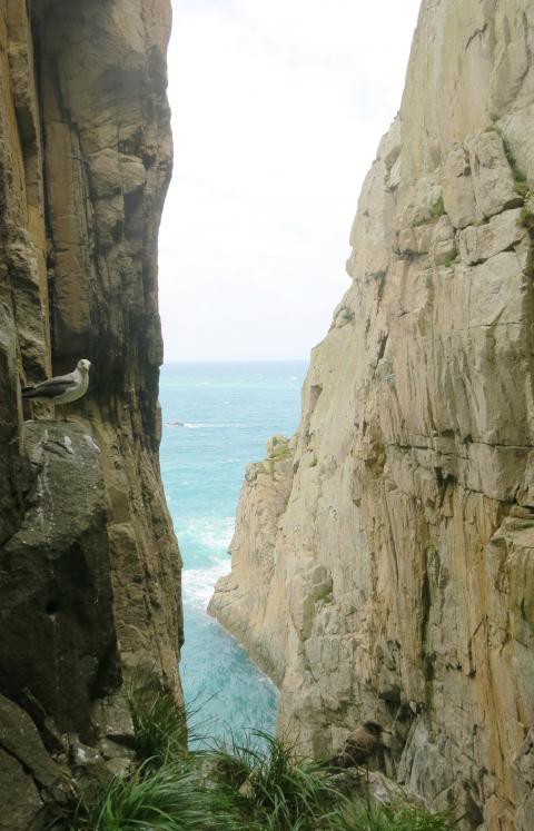
Photo: Richard Saunders
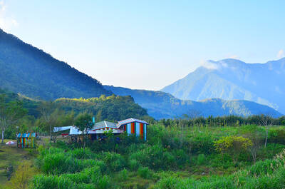
Ferries from Taiwan and Nangan Island (南竿島) all dock at Jhongjhu Harbor (中柱港), at the southern edge of Jhongliou (中柳村) and Lehua (樂華村) villages, which mingle to form the main settlement on the island.
Heading south from the harbor, the coast road climbs high above the ocean to turn west at Dongyin Visitor Center (東引旅客中心), where a side road descends to the seashore and Beihai Tunnel (北海隧道), dug between 1968 and 1970. At 148 meters, it’s the smallest of the three subterranean harbors in the Matsu islands. The others are on Nangan and Beigan (北竿) islands, but, like those, this one was dug by hand with the aid only of dynamite. Unfortunately it’s been “temporarily” closed for many years now, since the roof of the tunnel is apparently unstable.
Caves and tunnels
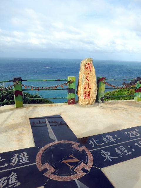
Photo: Richard Saunders
After the visitor center, take the next (signposted) turn on the right, and follow the signs to the trailhead for the short walk out to “Yanxiao Echoing with Tidal Cave” (燕秀潮音). This notable example of Chinglish describes a huge cavern whose roof has fallen in, exposing a deep, narrow crater, linked to the ocean by a long cleft, through which the sea pounds with an impressive roar. The cliffs on the crater side are densely covered in foliage so it’s hard to see into the void, but even half-glimpsed it’s an impressive place.
The main road now heads inland back toward Lehua village and Dongyin Distillery (東引酒廠), founded in 1961 and one of two distilleries in Matsu that produce Kaoliang spirit.
A kilometer or so further east, along a succession of signposted roads, lies Andong Tunnel (安東坑道), Dongyin’s most impressive military relic (excavated in the 1970s), and an unmissable attraction. The entrance to the complex is via a long, descending and seemingly endless tunnel which presents an interesting optical illusion, as it’s far longer than at first appears as you walk down. At the bottom, tunnels branch off in different directions, several ending suddenly at dramatic viewpoints in vertical sea cliffs. The gun turrets at Andong Tunnel are favorite bird watching spots, and the sight of large flocks of seagulls and terns circling in the deep sea-worn chasms is one of Matsu’s most memorable experiences.
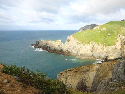
Photo: Richard Saunders
The western half of Dongyin has some impressive sights, but it’s the easternmost peninsula of the island (just a short zip by hire scooter from Jhongliu village) where the most breathtaking coastal scenery is found. First, below a small military compound, is the incredible cleft, Thread of Sky. A soldier may or may not walk up with pen and paper as you draw up at the parking area. Sign in with your ID if he does, and follow the steps down the grassy hillside and into the crevice. Thread of Sky isn’t especially big, but it’s extremely narrow, as the name suggests, and the short walk down there is stunning.
Killer views
Another couple of hundred meters east, steps lead down from the road to the utterly spectacular Suicide Cliff, rightly Dongyin’s most famous sight. It’s just a few meters from the road to the end of the natural, diving board-like tongue of land that extends into this fearsome ocean-eroded chasm, but the view down the sheer cliffs to the rocks far below is guaranteed to give vertigo sufferers a severe case of the willies.
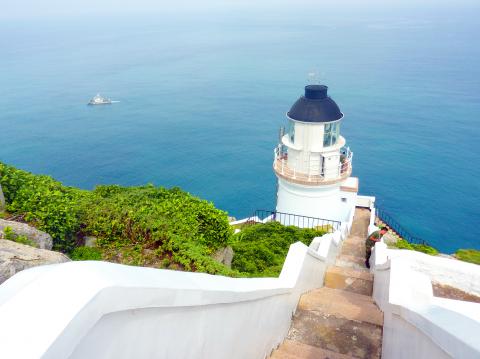
Photo: Richard Saunders
Historic monument
At the easternmost tip of the island a path follows the cliffs to the historic, British-designed Dongyin Lighthouse (東引燈塔), a Grade Three Historic Monument completed in 1904.
The lighthouse stands in a wild and magnificent spot, halfway up a craggy cliff, and the views over the cliffs and the ocean far below are inspirational on a good day. A side trail on the right on the way to the lighthouse leads down the cliffs to a pair of fog cannons, used in the past when poor visibility meant the lighthouse was ineffective.
The independent island of Xiyin is joined to the bigger Dongyin by the 500 meter-long Jhongjhu causeway (completed in 1986). Once across the causeway, follow the road uphill onto Xiyin’s steep slopes and several fine natural and military attractions. Most unmissable is the clifftop viewing platform called the Guojhih Beijiang (國之北疆), or Northernmost Frontier.
This point (or rather the Beigu Reef (北固礁) just offshore) constitutes the northernmost territory of the Matsu archipelago, and is certainly a fittingly majestic spot. The view, incorporating the rock pinnacles of the Luohanping (羅漢坪), or Eighteen Luohan, is as wild and exhilarating as any to be found in Taiwan.
Richard Saunders is a classical pianist and writer who has lived in Taiwan since 1993. He’s the founder of a local hiking group, Taipei Hikers, and is the author of six books about Taiwan, including Taiwan 101 and Taipei Escapes. Visit his Web site at www.taiwanoffthebeatentrack.com.
If one asks Taiwanese why house prices are so high or why the nation is so built up or why certain policies cannot be carried out, one common answer is that “Taiwan is too small.” This is actually true, though not in the way people think. The National Property Administration (NPA), responsible for tracking and managing the government’s real estate assets, maintains statistics on how much land the government owns. As of the end of last year, land for official use constituted 293,655 hectares, for public use 1,732,513 hectares, for non-public use 216,972 hectares and for state enterprises 34 hectares, yielding
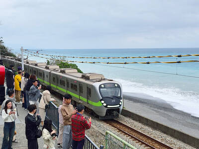
The small platform at Duoliang Train Station in Taitung County’s Taimali Township (太麻里) served villagers from 1992 to 2006, but was eventually shut down due to lack of use. Just 10 years later, the abandoned train station had become widely known as the most beautiful station in Taiwan, and visitors were so frequent that the village had to start restricting traffic. Nowadays, Duoliang Village (多良) is known as a bit of a tourist trap, with a mandatory, albeit modest, admission fee of NT$10 giving access to a crowded lane of vendors with a mediocre view of the ocean and the trains
Traditionally, indigenous people in Taiwan’s mountains practice swidden cultivation, or “slash and burn” agriculture, a practice common in human history. According to a 2016 research article in the International Journal of Environmental Sustainability, among the Atayal people, this began with a search for suitable forested slopeland. The trees are burnt for fertilizer and the land cleared of stones. The stones and wood are then piled up to make fences, while both dead and standing trees are retained on the plot. The fences are used to grow climbing crops like squash and beans. The plot itself supports farming for three years.

President William Lai (賴清德) on Nov. 25 last year announced in a Washington Post op-ed that “my government will introduce a historic US$40 billion supplementary defense budget, an investment that underscores our commitment to defending Taiwan’s democracy.” Lai promised “significant new arms acquisitions from the United States” and to “invest in cutting-edge technologies and expand Taiwan’s defense industrial base,” to “bolster deterrence by inserting greater costs and uncertainties into Beijing’s decision-making on the use of force.” Announcing it in the Washington Post was a strategic gamble, both geopolitically and domestically, with Taiwan’s international credibility at stake. But Lai’s message was exactly