Typhoon Podul is expected to make landfall near Taitung at about noon today and cut through southern Taiwan before moving into the Taiwan Strait in the late afternoon or evening, the Central Weather Administration (CWA) said this morning.
Hualien and Taitung counties in eastern Taiwan and the Hengchun Peninsula (恆春) in the southernmost part of the main island were already experiencing stronger winds and heavier rain this morning.
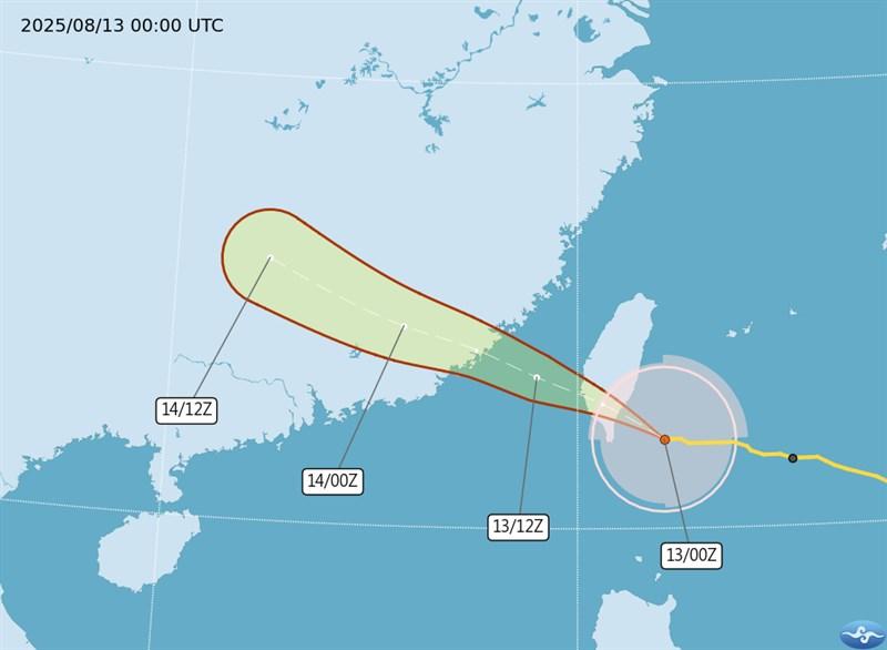
Photo courtesy of the Central Weather Administration
The CWA warned areas south of Chiayi County of similar conditions in the afternoon.
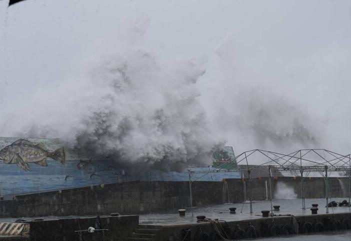
Photo: Liu Jen-wei, Taipei Times
Podul (the 11th typhoon of the season) has slightly intensified, with its center located over waters east-southeast of Taitung and moving west-northwest, the agency said.
The storm's radius reached land in Hualien, Taitung and the Hengchun Peninsula by 6am, the CWA said.
As of 10am, its eye was 90km southeast of Taitung, and moving west-northwest at 32kph, CWA data showed.
It was carrying maximum sustained winds near its center of 155kph, with gusts of up to 191kph.
CWA forecaster Liu Yu-chi (劉宇其) said the typhoon's center is expected to make landfall near Taitung at about noon, before moving out to sea from southern Taiwan in the afternoon or evening, and hitting coastal areas in southern China by early tomorrow morning.
The storm would be at its peak during the day today, with eastern Taiwan, Chiayi and areas to the south, and Penghu County seeing the most significant effects, including heavy rain or localized torrential rain, the CWA said.
Hualien, Taitung and mountainous areas in the south have a high likelihood of rainfall reaching extreme heavy rain levels (24-hour accumulated rainfall exceeding 200mm, or three-hour accumulated rainfall exceeding 100mm) or above.
Highs of 27°C to 30°C are forecast for Chiayi and areas to its south and eastern Taiwan, while areas between Miaoli County and Changhua County should see highs of 36°C, and the rest of the main island should expect highs of 32°C to 33°C, the CWA said.
Due to the typhoon and its outer bands, the CWA said parts of Taitung — including Green Island (綠島) and Orchid Island (Lanyu, 蘭嶼) — have experienced gusts of 150kph, and even stronger gust can be expected in those areas later in the day.
Hualien, Taitung and the Hengchun Peninsula may see gusts of 103kph or higher, while Penghu may see sustained winds of 103kph or gusts of 118kph or higher.
Meanwhile, Taiwan High Speed Rail Corp (THSRC) said the high-speed rail would run normally until 2pm, and then switch to three all-stop, non-reserved seat trains (excluding business class cars) every hour as Typhoon Podul approaches.
The revised schedule is to begin at 2pm, with trains departing each hour from Nangang Station (southbound) in Taipei and Zuoying Station (northbound) in Kaohsiung on the hour and at 20 and 40 minutes past the hour from each terminus, THSRC said in a statement.
The adjustment was made based on the latest weather information early this morning and an overall assessment of train operation safety, it said.
The schedule changes mean that the last trains today are to depart from Nangang Station at 9:40pm to Zuoying, and 10:40pm to Taichung; and from Zuoying Station at 9:40pm to Nangang, and 10:40pm to Taichung, it said.
Passengers with tickets during the period from when the sea typhoon warning was issued — yesterday, in Podul's case — to when it is canceled can request a full refund without service fees within one year from the travel date at any THSRC station.
This applies whether the trains operated normally, but were not boarded, or were rescheduled or canceled during that period.
Passengers holding tickets for affected services who switch to a lower-fare class may claim the fare difference at station ticket counters within one year from the travel date.
THSRC also said that to ensure operational safety during the typhoon, trains would operate at reduced speeds if wind speeds or rainfall in a particular section of the rail line exceed safety limits.
In the event of delays caused by these safety measures, which are considered natural factors, the delay compensation policy would not apply, the company said.
It advised passengers to allow extra time for transfers and connections to ensure smooth subsequent travel.
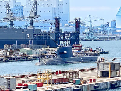
AGING: While Japan has 22 submarines, Taiwan only operates four, two of which were commissioned by the US in 1945 and 1946, and transferred to Taiwan in 1973 Taiwan would need at least 12 submarines to reach modern fleet capabilities, CSBC Corp, Taiwan chairman Chen Cheng-hung (陳政宏) said in an interview broadcast on Friday, citing a US assessment. CSBC is testing the nation’s first indigenous defense submarine, the Hai Kun (海鯤, Narwhal), which is scheduled to be delivered to the navy next month or in July. The Hai Kun has completed torpedo-firing tests and is scheduled to undergo overnight sea trials, Chen said on an SET TV military affairs program. Taiwan would require at least 12 submarines to establish a modern submarine force after assessing the nation’s operational environment and defense

Yangmingshan National Park authorities yesterday urged visitors to respect public spaces and obey the law after a couple was caught on a camera livestream having sex at the park’s Qingtiangang (擎天崗) earlier in the day. The Shilin Police Precinct in Taipei said it has identified a suspect and his vehicle registration number, and would summon him for questioning. The case would be handled in accordance with public indecency charges, it added. The couple entered the park at about 11pm on Thursday and began fooling around by 1am yesterday, the police said, adding that the two were unaware of the park’s all-day live
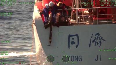
The coast guard today said that it had disrupted "illegal" operations by a Chinese research ship in waters close to the nation and driven it away, part of what Taipei sees a provocative pattern of China's stepped up maritime activities. The coast guard said that it on Thursday last week detected the Chinese ship Tongji (同濟號), which was commissioned only last year, 29 nautical miles (54km) southeast of the southern tip of Taiwan, although just outside restricted waters. The ship was observed lowering ropes into the water, suspected to be the deployment of scientific instruments for "illegal" survey operations, and the coast

A former soldier and an active-duty army officer were yesterday indicted for allegedly selling classified military training materials to a Chinese intelligence operative for a total of NT$79,440. The Taipei District Prosecutors’ Office indicted Chen Tai-yin (陳泰尹) and Lee Chun-ta (李俊達) for contravening the National Security Act (國家安全法) and the Anti-Corruption Act (貪污治罪條例). Chen left the military in September 2013 after serving alongside then-staff sergeant Lee, now an army lieutenant, at the 21st Artillery Command of the army’s Sixth Corps from 2011 to 2013, according to the indictment. Chen met a Chinese intelligence operative identified as “Wang” (王) through a friend in November