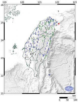
A magnitude 5.9 earthquake struck off Taiwan’s east coast at 3:24am yesterday, the Central Weather Bureau said, adding that the nation has seen more active and frequent seismic activity this year.
The hypocenter of yesterday’s earthquake was 59.3km east of Hualien County Hall at a depth of 17.9km, data collected by the bureau’s Seismological Center showed.
The earthquake was felt nationwide, with the largest intensity reaching level 4, the bureau said.
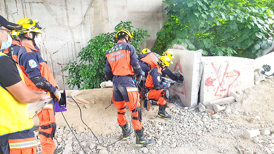
Photo courtesy of the New Taipei City Fire Department
No casualties were reported as of press time last night.
Residents on the east coast are still recovering from severe infrastructure damage caused by a magnitude 6.8 earthquake on Sept. 18.
Yesterday’s earthquake was caused by the Philippine Sea Plate subsiding into the Eurasian Continental Plate, Seismological Center Director Chen Kuo-chang (陳國昌) said, adding that it was not related to the Sept. 18 quake.
However, the epicenter of yesterday’s earthquake was almost in the same region as that of a magnitude 6.06 earthquake on Jan. 3, Chen said.
Since 1973, only 25 earthquakes exceeding magnitude 5.5 at a depth of less than 30km have been detected in that region, eight of which exceeded magnitude 6, Chen said.
The biggest one that occurred in the region was a magnitude 6.8 earthquake on March 31, 2002, he said.
Construction on the Taipei 101 building was suspended as a crane on the building’s roof fell after the quake, killing five workers and damaging multiple vehicles, Chen said.
While certain locations, such as Taipei’s Xinyi District (信義), are far from the epicenter, residents tend to experience intense shaking due to seismic site effects, in which seismic waves are amplified in superficial geological layers, he said.
Although yesterday’s earthquake nearly reached magnitude 6, it is not likely to trigger many aftershocks, Chen said.
“The earthquake occurred in a geologically fragmented zone, so aftershocks should occur quickly afterward. Our estimate is that no aftershock will occur if nothing happened the day after the earthquake. If there is an aftershock, it could reach magnitude 4.5 or greater,” he said.
Chen said that aftershocks triggered by the earthquake on Sept. 18 have shown signs of gradually subsiding, although the bureau still recorded four aftershocks on Monday, which was “unusual.”
Seismic activity around Taiwan proper has been more active and frequent this year, Chen said.
Taiwan has an average of two or three earthquakes exceeding magnitude 6 per year, but eight earthquakes larger than magnitude 6 have been recorded so far this year, he said.
“As of yesterday, 55 earthquakes of magnitude 5 to 6 had occurred this year. The average, however, is 24 to 25 per year,” Chang said, adding that more seismic activity is expected during the remainder of this year.

The military has spotted two Chinese warships operating in waters near Penghu County in the Taiwan Strait and sent its own naval and air forces to monitor the vessels, the Ministry of National Defense (MND) said. Beijing sends warships and warplanes into the waters and skies around Taiwan on an almost daily basis, drawing condemnation from Taipei. While the ministry offers daily updates on the locations of Chinese military aircraft, it only rarely gives details of where Chinese warships are operating, generally only when it detects aircraft carriers, as happened last week. A Chinese destroyer and a frigate entered waters to the southwest
A magnitude 6.1 earthquake struck off the coast of Yilan County at 8:39pm tonight, the Central Weather Administration (CWA) said, with no immediate reports of damage or injuries. The epicenter was 38.7km east-northeast of Yilan County Hall at a focal depth of 98.3km, the CWA’s Seismological Center said. The quake’s maximum intensity, which gauges the actual physical effect of a seismic event, was a level 4 on Taiwan’s 7-tier intensity scale, the center said. That intensity level was recorded in Yilan County’s Nanao Township (南澳), Hsinchu County’s Guansi Township (關西), Nantou County’s Hehuanshan (合歡山) and Hualien County’s Yanliao (鹽寮). An intensity of 3 was

Japanese Prime Minister Sanae Takaichi’s comment last year on Tokyo’s potential reaction to a Taiwan-China conflict has forced Beijing to rewrite its invasion plans, a retired Japanese general said. Takaichi told the Diet on Nov. 7 last year that a Chinese naval blockade or military attack on Taiwan could constitute a “survival-threatening situation” for Japan, potentially allowing Tokyo to exercise its right to collective self-defense. Former Japan Ground Self-Defense Force general Kiyofumi Ogawa said in a recent speech that the remark has been interpreted as meaning Japan could intervene in the early stages of a Taiwan Strait conflict, undermining China’s previous assumptions
Taiwan Railways Corp (TRC) today announced that Shin Kong Mitsukoshi has been selected as the preferred bidder to operate the Taipei Railway Station shopping mall, replacing the current operator, Breeze Development Co Ltd. Among eight qualified firms that delivered presentations and were evaluated by a review committee, Shin Kong Mitsukoshi was ranked first, while Breeze was named the runner-up, the rail company said in a statement. Contract negotiations are to proceed in accordance with regulations, it said, adding that if negotiations with the top bidder fail, it could invite the second-ranked applicant to enter talks. Breeze in a statement today expressed doubts over