DPP officials yesterday expressed regret over Beijing's refusal to renounce military intimidation of Taiwan, saying the declaration has once again hurt the feelings of Taiwanese.
But the officials said that the public shouldn't be overly concerned with China's attitude, as it is merely a continuation of communist party policy and does not represent any new threat.
Taiwan received a flat rebuff from China two days after President Chen Shui-bian (
Chen told the Chinese leaders that Taiwan would not change its status quo if Beijing stops threatening Taiwan militarily.
But yesterday, China's Defense Minister Chi Haotian (
DPP Secretary-General Chang Chun-hsiung (
The secretary general called on Beijing not to consider Taiwan its rival and asked that China work with Taiwan to seek peace.
Director of the DPP's Chinese Affairs Department Chen Chung-hsin (
He said that while the government does not expect China's attitude to be easily changed, there may be room for flexibility in terms of the tactics the government can use when dealing with Beijing.
The president has proposed using civil organizations to negotiate with China. Beijing has said it welcomes that initiative.
President Chen's recent tough remarks on China have triggered public concern that his shift in attitude could rile Beijing and make the resumption of dialogue impossible.
But DPP officials have said they do not believe the comments would affect cross-strait relations given that the DPP is still committed to a peaceful resolution of the cross-strait dispute.

Yangmingshan National Park authorities yesterday urged visitors to respect public spaces and obey the law after a couple was caught on a camera livestream having sex at the park’s Qingtiangang (擎天崗) earlier in the day. The Shilin Police Precinct in Taipei said it has identified a suspect and his vehicle registration number, and would summon him for questioning. The case would be handled in accordance with public indecency charges, it added. The couple entered the park at about 11pm on Thursday and began fooling around by 1am yesterday, the police said, adding that the two were unaware of the park’s all-day live

Fast food chain McDonald's is to raise prices by up to NT$5 on some products at its restaurants across Taiwan, starting on Wednesday next week, the company announced today. The prices of all extra value meals and sharing boxes are to increase by NT$5, while breakfast combos and creamy corn soup would go up by NT$3, the company said in a statement. The price of the main items of those meals, if ordered individually, would remain the same. Meanwhile, the price of a medium-sized lemon iced tea and hot cappuccino would rise by NT$3, extra dipping sauces for chicken nuggets would go up
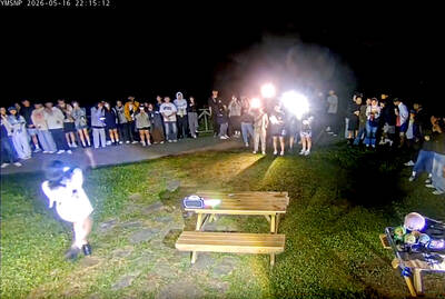
Yangmingshan National Park’s Qingtiangang (擎天崗) nature area has gone viral after a park livestream camera observed a couple in the throes of intimate congress, which was broadcast live on YouTube, drawing large late-night crowds and sparking a backlash over noise, bright lights and disruption to wildlife habitat. The area’s livestream footage appeared to show a couple engaging in sexual activity on a picnic table in the park on Friday last week, with the uncensored footage streamed publicly online. The footage quickly spread across social media, prompting a tide of visitors to travel to the site to “check in” and recreate the

Minister of Digital Affairs Lin Yi-ching (林宜敬) yesterday cited regulatory issues and national security concerns as an expert said that Taiwan is among the few Asian regions without Starlink. Lin made the remarks on Facebook after funP Innovation Group chief executive officer Nathan Chiu (邱繼弘) on Friday said Taiwan and four other countries in Asia — China, North Korea, Afghanistan and Syria — have no access to Starlink. Starlink has become available in 166 countries worldwide, including Ukraine, Malaysia, the Philippines and Vietnam, in the six years since it became commercial, he said. While China and North Korea block Starlink, Syria is not