More than 500 cases of damage to public infrastructure and private property had been reported as Tropical Storm Nesat moved away from Taiwan yesterday after causing destruction nationwide.
After the downpours drenched northern and eastern Taiwan over the past two days, 509 cases of destruction to roads and facilities, including 244 in Taipei and 145 in New Taipei City, were reported across the nation as of 3pm yesterday, the National Fire Agency said.
In New Taipei City, 70 people in a residential community in Sijhih District (汐止), where heavy rain on Sunday night triggered a mudslide, were all safe and waiting to be evacuated, officials said.
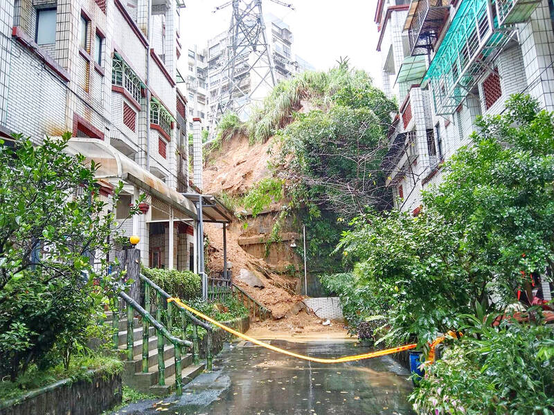
Photo: Tien Yu-hua, Taipei Times
Earlier yesterday morning, a total of 297 motorists and passengers trapped on Provincial Highway 7 in Yilan County since the previous night were rescued, the emergency operation center said, adding that some of them were taken to the Chilan Resort in Datong Township (大同).
Traffic on two sections of national highways — the 114.6k to 167.1k mark on Provincial Highway 8 and the 25k to 44k mark on the Southern Cross-Country Highway — were partially resumed later yesterday and is scheduled to fully reopen tomorrow morning, the Directorate-General of Highways said.
Repairs on four damaged sections of provincial highways in Taoyuan, Yilan and Taitung counties were being made and traffic is expected to return to normal today, authorities added.
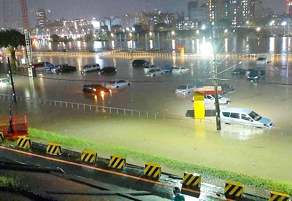
Photo by Cheng Ming-hsiang, Taipei Times
In Taipei, more than 100 vehicles were stuck in floodwater in a parking lot outside floodgates near the Bailing Bridge (百齡橋), and a “yellow” landslide warning was issued in some areas.
Many car owners said the city government sent a notice too late for them to move their vehicles.
To avoid a recurrence, Taipei Mayor Ko Wen-je (柯文哲) called for enhanced cooperation with the central government to establish a better early warning system, improving the messaging system to notify drivers whose vehicles are parked outside floodgates and allocating a budget to integrate the emergency operation center and the big data center.
“However, the government is only responsible for notifying vehicle owners. Each citizen should take responsibility for their own behavior [on whether they move their vehicle after receiving a notification],” he said.
The Central Weather Bureau said that chances of extremely heavy rain or heavy rain triggered by the storm’s outer ring are high in regions north of Taoyuan and the northeastern parts of the country, warning that precipitation and gusty winds could continue in those areas today.
With the current seasonal northeasterly wind system gathering strength, daytime temperatures in northern Taiwan are expected to dip to as low as 17oC today, it added.
Northern Taiwan is expected to feel the most apparent pinch resulting from the wind effects, and temperature highs are forecast to range between 18oC and 19oC, with some open areas likely to see the mercury fall to 17oC today, it said.
Elsewhere in Taiwan, warmer weather is possible, with daytime temperatures forecast to range between 20oC and 21oC, it said.
Former bureau Weather Forecast Center director Daniel Wu (吳德榮), an adjunct associate professor of atmospheric sciences at National Central University, added that the weather conditions were expected to improve from tomorrow, while it would stay cool in the early hours of the morning.
The mercury is expected to start recovering from Thursday, but a wide daytime-nighttime temperature gap is possible, he said.

The subsidiary of Taiwan Semiconductor Manufacturing Co (TSMC, 台積電) in Kumamoto, Japan, turned a profit in the first quarter of this year, marking the first time the first fab of the unit has become profitable since mass production started at the end of 2024. According to the contract chipmaker’s financial statement released on Friday, Japan Advanced Semiconductor Manufacturing Inc (JASM), a joint venture running the fab in Kumamoto, posted NT$951 million (US$30.19 million) in profit in the January-to-March period, compared with a loss of NT$1.39 billion in the previous quarter, and a loss of NT$3.25 billion in the first quarter of
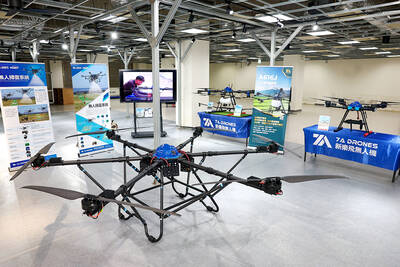
DRONE CENTRAL: Taiwan aims to become Asia’s democratic hub for drones, with most exports focused on high-quality military-grade models, an official said Taiwan’s drone industry is expected to expand significantly by 2030, producing 100,000 units per month and exporting half of them, the Ministry of Economic Affairs said yesterday. Current drone production capacity is about 15,000 units per month, but the industry can quickly scale up as demand increases, Industrial Development Administration Director-General Chiou Chyou-huey (邱求慧) told a news conference in Taipei. Taiwan’s drone output grew 2.5-fold last year to NT$12.9 billion (US$408.3 million) under a government program to develop the uncrewed vehicle sector, he said. The Executive Yuan in October last year approved plans to invest NT$44.2 billion into domestic production of uncrewed aerial
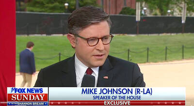
RESOLUTE BACKING: Two Republican senators are planning to introduce legislation that would impose immediate sanctions on China if it attempts to invade Taiwan US House of Representatives Speaker Mike Johnson on Sunday reaffirmed US congressional support for Taiwan, saying the US and “all freedom-loving people” have a stake in preventing China from seizing Taiwan by force. Johnson made the remarks in an interview with Fox News Sunday on US President Donald Trump’s summit with Chinese President Xi Jinping (習近平) last week. In an interview that aired on Friday on Fox News, just as Trump wrapped up a high-stakes visit to China, he said he has yet to green-light a new US$14 billion arms package to Taiwan and that it “depends on China.” “It’s a very good
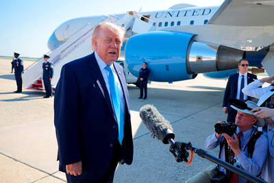
US President Donald Trump yesterday said he would speak to President William Lai (賴清德) as his administration considers whether to move ahead with a US$14 billion weapons sale to Taiwan — a potential arms deal that has drawn criticism from China. “Well, I’ll speak to him. I speak to everybody,” Trump told reporters yesterday when asked if he had any plans to call his counterpart, although he did not offer a time frame for when such a conversation could take place. Trump previously said he would speak to the person “that’s running Taiwan,” without specifying who he meant. “We have that situation very