A powerful typhoon shifted and abruptly gained strength yesterday as it blew closer to the northeastern Philippines, prompting evacuations from high-risk villages and the capital, which could be sideswiped by the storm, officials said.
Typhoon Noru was swirling at sea about 115km east of Infanta town in Quezon Province, with sustained winds of 195kph and gusts of up to 240kph.
While barreling toward the archipelago, Noru changed track southward, pushed down by a high-pressure area to its north. It gained considerable strength, transforming from a storm with sustained winds of 85kph on Saturday into a super typhoon just 24 hours later in an “explosive intensification” at sea, Philippine Atmospheric, Geophysical and Astronomical Services Administration head Vicente Malano said.
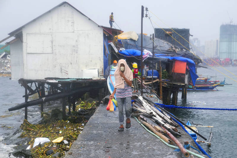
Photo: AP
The rapid intensification as it neared land was “unprecedented” storm behavior, weather forecaster Robb Gile said.
Thousands of villagers in Quezon Province were evacuated from the typhoon’s path, as well as from mountainside villages that are prone to landslides and flash floods, and in coastal communities that could be hit by tidal surges as high as 3m.
“The combined effects of a storm surge and high waves breaking along the coast may cause life-threatening and damaging inundation or flooding,” the weather agency warned.
In Manila’s seaside district of Tondo, some residents left their homes with bags of belongings and hurriedly walked to a nearby evacuation center as the sky darkened and rains started to fall.
Provincial disaster management head Melchor Avenilla said law enforcers were under orders to forcibly move people who refuse to leave their homes.
“So far we’ve been able to do this by just appealing to people,” Avenilla said.
The typhoon’s eye could pass about 40km to 50km from metro Manila, “which is nearly a direct hit,” Malano said.
Fishing boats and inter-island and cargo ferries were restricted to port as a precaution, the coast guard said.
Cargo trucks and more than 2,500 passengers were stranded. More than 30 flights at Manila’s airport, mostly bound for domestic destinations, were canceled.
The typhoon was forecast to sweep through Luzon Island last night and into the South China Sea today. It is on track to hit Vietnam later in the week while maintaining its powerful winds.
Noru comes nine months after another super typhoon devastated swathes of the country, killing more than 400 people and leaving hundreds of thousands homeless.
Additional reporting by AFP

South Korea has adjusted its electronic arrival card system to no longer list Taiwan as a part of China, a move that the Ministry of Foreign Affairs said would help facilitate exchanges between the two sides. South Korea previously listed “Taiwan” as “Taiwan (China)” in the drop-down menus of its online arrival card system, where people had to fill out where they came from and their next destination. The ministry had requested South Korea make a revision and said it would change South Korea’s name on Taiwan’s online immigration system from “Republic of Korea” to “Korea (South),” should the issue not be

The Legislative Yuan’s Finance Committee yesterday approved proposed amendments to the Amusement Tax Act (娛樂稅法) that would abolish taxes on films, cultural activities and competitive sporting events, retaining the fee only for dance halls and golf courses. The proposed changes would set the maximum tax rate for dance halls and golf courses at 50 and 20 percent respectively, with local governments authorized to suspend the levies. Article 2 of the act says that “amusement tax shall be levied on tickets sold or fees charged by amusement places, facilities or activities” in six categories: “Cinema; professional singing, story-telling, dancing, circus, magic show, acrobatics

Tainan, Taipei and New Taipei City recorded the highest fines nationwide for illegal accommodations in the first quarter of this year, with fines issued in the three cities each exceeding NT$7 million (US$220,639), Tourism Administration data showed. Among them, Taipei had the highest number of illegal short-term rental units, with 410. There were 3,280 legally registered hotels nationwide in the first quarter, down by 14 properties, or 0.43 percent, from a year earlier, likely indicating operators exiting the market, the agency said. However, the number of unregistered properties rose to 1,174, including 314 illegal hotels and 860 illegal short-term rental

INFLATION UP? The IMF said CPI would increase to 1.5 percent this year, while the DGBAS projected it would rise to 1.68 percent, with GDP per capita of US$44,181 The IMF projected Taiwan’s real GDP would grow 5.2 percent this year, up from its 2.1 percent outlook in January, despite fears of global economic disruptions sparked by the US-Iran conflict. Taiwan’s consumer price index (CPI) is projected to increase to 1.5 percent, while unemployment would be 3.4 percent, roughly in line with estimates for Asia as a whole, the international body wrote in its Global Economic Outlook Report published in the US on Monday. The figures are comparatively better than the IMF outlook for the rest of the world, which pegged real GDP growth at 3.1 percent, down from 3.3 percent