On Sept. 23 at 2:50pm, the Mataian River (馬太鞍溪) landslide dam failed after the torrential rains brought by Typhoon Ragasa, releasing millions of tons of water that rushed downstream, reaching Guangfu Township (光復) in Hualien County at around 4pm. As of this writing, 18 have been confirmed dead from the flooding.
The barrier lake was formed by a landslide in late July. First detected on July 26, it had been under extensive monitoring by central government authorities and researchers. Nothing could be done on the barrier dam itself because of the site’s remoteness — by government estimates nearly three years would be required to put in a 15km access road to bring in equipment. Moreover, altering the dam was considered risky given its instability and ability of water to get around or over it.
The authorities thus proceeded with evacuations as the obvious response. In mid-August, a typhoon had forced the evacuation of several hundred residents. The Ministry of Agriculture late last month formed a task force, predicting that the dam might overflow early this month. Donghua University experts released preliminary evacuation maps early last month, which were followed by testing of a cellphone-based early warning system for the area. On Sept. 22, around 8,500 residents were evacuated as Ragasa approached, saving hundreds of lives. Ministry of Economic Affairs Water Resources Agency Director-General Lin Yuan-peng (林元鵬) said shortly after the disaster that the deaths all occurred in designated evacuation areas.
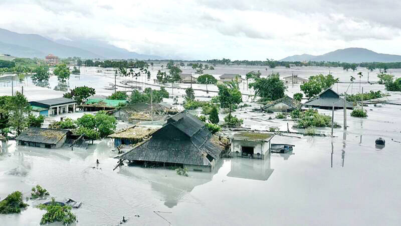
Photo courtesy of Sung Yu-teng
Why was Guangfu struck? The short answer is that the town is built on a floodplain. The long answer is the interplay of decisions made by successive Japanese and Chinese Nationalist Party (KMT) colonial regimes, a situation that is common across Taiwan.
JAPANESE ERA
In the 19th century there was no town there. Instead, the area was inhabited largely by Amis indigenous people, who today make up roughly half of the town’s population. The indigenous communities were sited on hills above the floodplain, for defense and safety from floods.
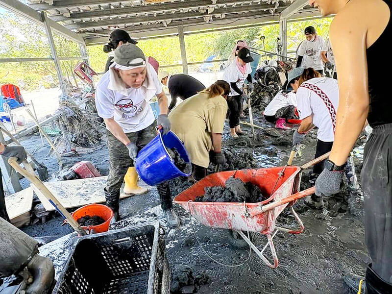
Photo: File photo
After the beginning of the 20th century the Japanese brought in large-scale water engineering, and seized the floodplain lands of the indigenous people for sugar growing. To keep the floodplain safe, they put in a system of dikes which form the basis of today’s water management system. The dikes were deliberately constructed with three gaps that permitted water to flow from the plain back into the river and its adjacent floodplain. These gaps have come under much local scrutiny in the wake of the disaster, though Water Resources Agency General Director, Lin Yuan-peng (林元鵬) said that the volume of water, four times greater than expected, would have overtopped the dikes even without the gaps.
In the Japanese period, the indigenous settlements remained on their hillside locations. The Japanese built a sugar factory in 1913, and brought in workers whom they housed in a settlement to the south.
The Japanese ran a railway down the Nakasendo Plain, what we now call the East Rift Valley (花東縱谷), early in the 20th century. The flat plain suited the Japanese emperor’s railroad engineers, and the rail line reached the area in 1913, to pick up sugar at the newly-christened Mataian Station. In the 1930s the station was renamed, and a small settlement grew up around it. The area was known as Fataan, or “pigeon pea,” from its staple crop. The nearby Amis village was called Tafalong.
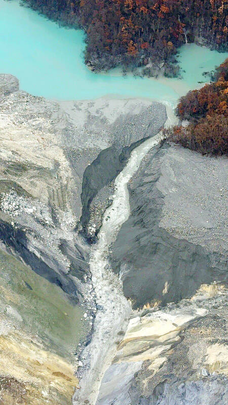
Photo courtesy of Forestry and Nature Conservation Agency, Hualien branch
These indigenous villages sitting on hills nearby were spared inundation in the barrier lake disaster. This is a pattern seen in other disasters, where the water floods areas that the indigenous and early Han settlers had ignored because of their dangerous flood patterns, but where modern Japanese and KMT engineers had built extensive water management systems, as if daring nature to defeat them — a challenge nature always accepts, and never loses.
After 1949, following its usual colonial patterns, the KMT renamed the town, first to Taian and then to Guangfu (“Retrocession”), the KMT’s term for its seizure of Taiwan after World War II. At present there is a movement to return the town’s name to its original indigenous name, but it has gone nowhere.
The KMT government restored the sugar plant (it had been bombed by the US during World War II) and operations resumed in 1948. Because Guangfu is sited in a low part of the plain, the government raised the levees in front of the town to ward off floods. As so often with levee construction and river management, this created a new problem. In the old days the river would flood and leave its burden of silt in the floodplain, renewing the land. The water engineering prevents this, confining the silt to the river. Hence, the riverbed has risen.
BLAME GAME
The wrangling between the central and local government over who gets the blame for problems with the monitoring and evacuation warning obscures the long-term, man-made problem: Guangfu should never have been permitted to grow. The town and rail line should long ago have been moved to higher ground.
According to local netizen reports, silting has raised the river higher than the town itself. The problem of the rising riverbed was implicitly recognized in the government’s approval early last month of plans to dredge 2.3 million tons of silt from the river (according to the WRA’s Lin, 400,000 tons were removed) in the response to the barrier lake threat. The government also sandbagged the levees.
Guangfu lies on the south bank of the river. On the north side, construction of levees blocks flood waters from flowing into the farmland. Many netizens contended that the levee on the north side of the river should have been demolished to let the flood dissipate into largely uninhabited farmland.
The barrier lake remains a threat despite losing nearly 90 percent of its water in the catastrophe. Hopefully the authorities will become more aggressive in their responses.
Among ordinary people the response to the disaster has been amazing, yet also, normal. Taiwanese, and many foreigners, including migrant workers, rushed to the scene of the disaster to help with the clean up, just as they have done in countless other major disasters. This entirely natural response should serve as a reminder to outsiders that in the event of any disaster — such as an invasion — resistance and resilience will be instant and automatic.
Although the temptation to treat this disaster as a freak of nature is strong, it should be resisted. Quakes and rain catastrophes regularly spawn barrier lakes in the mountains: Typhoon Morakot in 2009 alone formed at least 16. These can easily become lethal, especially given Taiwan’s short rivers with their large silt loads and extensive engineering intended to move floods around communities in river basins. Barrier lake management needs to be better integrated into local water planning.
And for the love of all gods, the government needs to clamp down on silt-producing “development” in upstream areas. Clearing of land for farms and campgrounds, illegal and otherwise, isn’t just bad for water conservation. As Guangfu’s experience shows, it kills.
Notes from Central Taiwan is a column written by long-term resident Michael Turton, who provides incisive commentary informed by three decades of living in and writing about his adoptive country. The views expressed here are his own.

Ajay Verma, a consultant gastroenterologist at Kettering general hospital in Northamptonshire, says our gut is a “complex machine.” “It is constantly providing us with the nutrition we need, initially to grow and develop, and then for us to survive, thrive and repair from injury and illness.” How can we keep it functioning well? Put simply: “Make sure what you put into it is balanced, and that you clear out its waste products adequately,” Verma says. “In a general gastroenterology clinic, the most common conditions we see are irritable bowel syndrome (IBS), gastroesophageal reflux disease, inflammatory bowel disease and constipation,” says Nisha
The arithmetic is straightforward and uncomfortable. By the end of 2025, Taiwan had committed itself to a 50-30-20 electricity mix — half natural gas, 30 per cent coal, 20 per cent renewables. The Ministry of Economic Affairs’s (MOEA) own monthly energy reports tell a different story. Natural gas reached 47.8 per cent of generation last year. Coal stood at 35.4 per cent, comfortably above its target ceiling. Renewables came in at 13.1 per cent, well short of the 20 per cent Taipei had pledged a decade earlier. Installed renewable capacity reached roughly half of the 12 gigawatts (GW) the government

Last week US President Donald Trump was asked by a reporter whether he would speak on the phone to the President of Taiwan. “l’ll speak to him. I speak to everybody. We have that situation very well in hand,” Trump said. This marked the second time in a couple of weeks he had said he would talk to the President of Taiwan. In 2016 he famously took a call from then-president Tsai Ing-wen (蔡英文), when he was president-elect. Despite warnings that the apocalypse was nigh because of a phone call, the world quickly forgot about the conversation between two democratically-elected presidents.
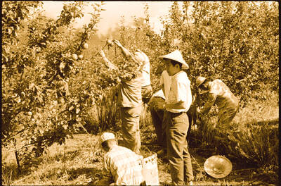
May 25 to May 31 Few believed that apples could be cultivated on a commercial scale in Taiwan’s high mountains. When horticulturalist Cheng Chao-hsiung (程兆熊) first proposed the idea in 1955, both American and Taiwanese colleagues dismissed it as implausible, arguing that temperate fruit could not be reliably grown on a subtropical island, especially on rugged terrain. However, it was this terrain in the Central Mountain Range where many Chinese Civil War veterans were resettled in the late 1950s. With limited job prospects and no family in Taiwan, they were placed on cooperative farms aimed toward self-sufficiency. Some say the conditions