While global attention is finally being focused on the People’s Republic of China (PRC) gray zone aggression against Philippine territory in the South China Sea, at the other end of the PRC’s infamous 9 dash line map, PRC vessels are conducting an identical campaign against Indonesia, most importantly in the Natuna Islands.
The Natunas fall into a gray area: do the dashes at the end of the PRC “cow’s tongue” map include the islands? It’s not clear. Less well known is that they also fall into another gray area. Indonesia’s Exclusive Economic Zone (EEZ) claim and continental shelf claim are not coincident in that area, as Australian security and defense expert Euan Graham pointed out on X (Twitter) last week. “China knows how to exploit a grey zone when it sees one,” he observed.
The Natuna Regency, the Indonesian administrative name for the region, contains “at least” 154 islands, 127 of which are uninhabited, according to Wikipedia. As always, after supplying some facts to orient the reader, Wiki then moves on to the history, where, in the very first sentence, we are treated to an amazing nonsense artifact: “The Natuna Islands were discovered by I-Tsing in 671 A.D. and mentioned throughout his notes in A Record of Buddhist Practices Sent Home from the Southern Sea.”
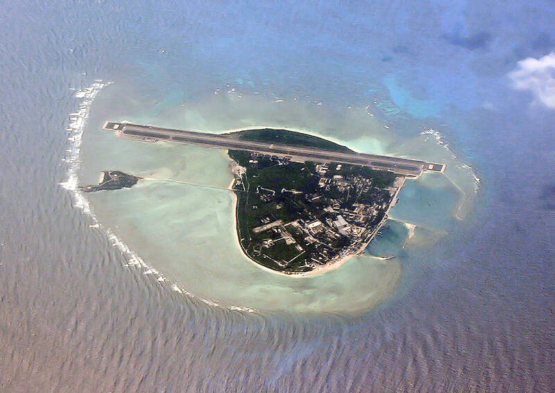
Photo courtesy of Wikimedia Commons
I-Tsing (Yijing, 義淨), was a Tang Dynasty Buddhist scholar whose travel writings are important sources of information on the routes between India, China and the kingdoms of what is today Malaysia and Indonesia. He is famed for translating Buddhist texts, and for his commentaries on the state of Buddhism in the places he visited. He did not, however, “discover” anything. He was a monk, incapable of operating a ship or recording navigational information. The only difference between himself and the cargo aboard the vessels he rode on was that he was alive.
Anyone who wants to see what Wikipedia would be like if PRC propagandists had unlimited access need only visit Quora, which on matters related to the PRC is nigh-on useless, thanks to the 50-cent brigade. But despite Wikipedia’s generally sturdy editing work, pro-PRC statements and frames like this creep in. As the first sentence in the “history” section, it subtly supports the PRC claim to the area by attributing “discovery” to someone from China.
YIJING’S ACCOUNTS
Photo courtesy of Wikimedia Commons
As history the statement is absurd. Tang-era ships did not play the routes between India, China and southeast Asia. In the seventh century that was the domain of Near Eastern and Indian seafarers who had been part of extensive trade networks across seas of India and southeast Asia for at least a millennium. Yijing himself records that he left from Guangzhou aboard a Persian vessel and sailed to Srivijaya in what is now Indonesia. Along the way he kept running notes on the locations he passed, on their customs and their adherence to Buddhism. It is obvious from both his notes and his occasional references that the islands he passed were inhabited (as many are today).
Yijing’s notes are merely the oldest surviving written account of the area. Since tablets with writing from the Srivijaya kingdom are known from shortly after his time, it is highly plausible that even that state is simply the luck of archaeological practice. Sooner or later earlier inscribed objects discussing the area will be unearthed.
However, there must have been written accounts galore. The loss of so much of the Greco-Roman classical corpus is generally mourned, but the loss of writings from southeast Asia must have been just as great. Yijing records the habits of Buddhist monks wherever he went, describing in minute detail their variations in habits. Buddhism is a text-based religion, and must have been transmitted from literate to literate. With the thousand monks then in residence, Yijing himself extols Srivijaya as an excellent place to study Buddhist texts. All lost, today.
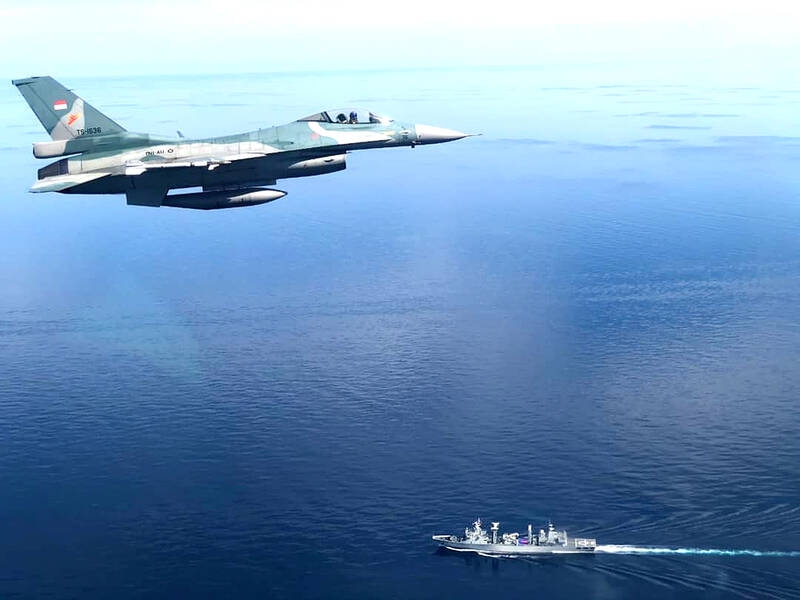
Photo courtesy of Wikimedia Commons
Yijing admits he is uncertain of the size of the area, and remarks that the merchants who regularly plied these waters would know. Scholars and dilettantes of our own age tend to focus on the literati of a bygone age, a subtle class solidarity that reaches across time, distorting what it touches. Yet, also lost is another enormous corpus of records: the rutters used by local pilots to navigate.
A rutter is a set of notes a navigator compiles about routes, landmarks, the sea and its currents and tides, the sea bottom, astronomy, climate, wind conditions and other aspects of navigation and port activities. The word in English comes down from Arabic, indicating the importance of Arab rutters in the development of similar western texts. The Persian ship that took Yijing to Indonesia must have had a set of rutters describing the route and its associated land masses in detail, developed over numerous voyages.
HISTORICAL PROPAGANDA
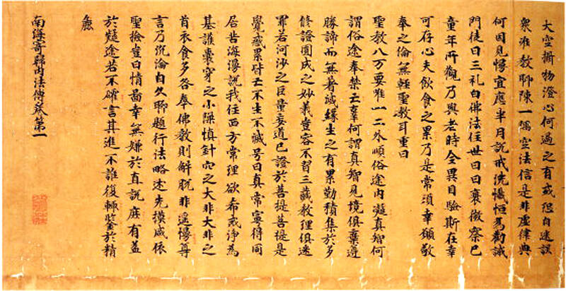
Photo courtesy of Wikimedia Commons
These conclusions about Yijing are also true of every other “historical link” invented or appropriated by the PRC for its historical propaganda. The PRC often cites the scribblings of its literati in their travels as legitimating texts for its expansionist claims, appealing to the historical bias that treats literati as a superior source of knowledge. The truth is that the Chinese literati, landlubbers traveling long-established routes, were always the last to know of a place. Centuries before them, the masters of the ships on which they traveled already knew the routes and recorded them in their rutters. Most of these have been lost.
One of the ways our social biases toward the literate and toward history as the story of the upper class help the PRC erase the past is that we forget the existence of documents like rutters, and the non-Han sailors who compiled them (going all the way back to the Austronesians and Negritos who first settled southeast Asia). PRC discourse wants us to focus on the Chinese and their activities, which not only moves them into prominence, but conceals the expert navigators who carried them and their trade goods from one place to another.
Since mid-October a Norwegian survey ship contracted by Indonesia has been in the Natunas performing a fossil fuel survey, and the PRC coast guard has parked a ship there to shadow it. Indonesian navy vessels have been unable to eject the PRC ships and clear the area. Each time the Indonesian authorities have reported ejecting them, the PRC coast guard has returned. As the Asia Maritime Transparency Initiative (AMTI) observes, though PRC vessels and the Indonesian coast guard have clashed before, this is the first time the Indonesian government has been so prompt in releasing information on PRC activities.
Expect the Natunas, and Yijing’s name, to come up more often.
Notes from Central Taiwan is a column written by long-term resident Michael Turton, who provides incisive commentary informed by three decades of living in and writing about his adoptive country. The views expressed here are his own.

Taiwan’s overtaking of South Korea in GDP per capita is not a temporary anomaly, but the result of deeper structural problems in the South Korean economy says Chang Young-chul, the former CEO of Korea Asset Management Corp. Chang says that while it reflects Taiwan’s own gains, it also highlights weakening growth momentum in South Korea. As design and foundry capabilities become more important in the AI era, Seoul risks losing competitiveness if it relies too heavily on memory chips. IMF forecasts showing Taiwan widening its lead over South Korea have fueled debate in Seoul over memory chip dependence, industrial policy and

And so, in the wake of US President Donald Trump’s trip to the People’s Republic of China (PRC), all the experts on the Strait of Hormuz suddenly became experts on US-China-Taiwan relations. The Internet has certainly expanded human knowledge. Lots of these sudden experts made noise this week about Trump’s words after the meeting with PRC dictator Xi Jin-ping (習近平). Trump is going to sell out Taiwan! Longtime Taiwan commentator J. Michael Cole summed the situation up neatly in the Guardian: “We need to keep in mind that he has a tendency to say many things — sometimes contradicting himself within

There is considerable frustration and confusion among many, both in Taiwan and abroad — including in Washington — as to why the Chinese Nationalist Party (KMT) seems so dead set on using their legislative leverage to slash defense spending and disrupt the ability of the ruling Democratic Progressive Party (DPP) administration to function. Are they pawns of the Chinese Communist Party (CCP)? Are they traitors? In reality, there are multiple reasons. In the first column in this series on this subject, “Donovan’s Deep Dives: How and why the TPP and KMT help Beijing” (Sat May 16, page 12), we examined three

It took 12 years and months of standing in the same mountain location for director Liang Chieh-te (梁皆得) to capture a few seconds of footage: Taiwan’s largest resident raptor locking talons with its mate and spinning through the air in a courtship ritual. With only about 1,000 left in the wild and very short flight windows, the mountain hawk-eagle remains among Taiwan’s most elusive birds. The species generally produces only one offspring per year. Using forest cameras, the film crew and research teams document the arduous process the monogamous pairs go through for the chick to hatch and grow up, weathering