Appearances can be deceptive, and that’s definitely the case with Baigu Mountain (白姑大山), the 3,341-meter-high mountain that straddles the border between Taichung and Nantou County. One of Taiwan’s “Top Hundred Peaks” (it comes in at 45 on the list) it’s a surprisingly little-known trek, considering permission to climb it is easier to get than most of its brethren (only a police permit is required), and it’s an absolutely cracking climb.
Baigu Mountain is among the tougher peaks on the list that I’ve done to date (it’s on a level with Chilai North Peak and Nanhu Mountain), but it repays all that effort with its unexpectedly stunning beauty. Photos of the mountain published on blogs and elsewhere usually show only the deceptively gentle, wooded summit dome, which appears little more challenging than a Yangmingshan peak. It’s a tough two-day hike, and one that’ll long stick in the memory, with plenty of knee-breaking ups and downs, and absolutely stunning views over the surrounding wilderness.
The trailhead lies in the middle of nowhere, at the very end of a long, winding track that climbs up from the little Aboriginal village of Hongsiang (紅香), itself reached by a long mountain road (now thankfully paved) from the villages of Wushe (霧社) to the south, or Lishan (梨山) in the north. The road is so narrow that anything bigger than an eight-seater minibus like the one we used to get up there won’t make it. Vehicles stop at the highest farmhouse on the road, guarded by a lovely black pup, sadly kept permanently chained to a post on the veranda of the building, and rather shy of strangers.
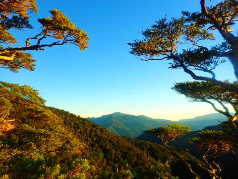
Photo: Richard Saunders
Above the farmhouse, a track winds up to a red metal sign that rather sternly announces that Baigu Mountain is “…an advanced trek, potentially dangerous in parts and only suitable for experienced hiking groups.” Baigu Mountain has a certain reputation among hiking groups, mainly because in the past it was often climbed from near Deji (德基) on highway eight, to the north, an extremely steep and strenuous route. Since the stretch of the highway on which that trailhead lies was closed following the devastating 921 Earthquake of 1999, the present trail, from the south, has become the only way to climb the mountain. Tragically, it was while climbing Baigu Mountain in 2011 that solo hiker Chang Po-wei (張博崴) became lost and fell into a gorge not far from the start of the trail. He was only found after a seven-week search, and had died only a few days before his body was found. His mother, Sharon, later went on to found the Taiwan Mountain Association, which has since been fighting to improve education, safety and access to Taiwan’s mountains, holding an annual international conference, and among much else successfully campaigning for easier access by hikers to PLBs (personal locator beacons), the import and use of which at the time of Chang’s accident were strictly controlled and extremely hard to obtain.
It’s four hours from the trailhead to the rough campsite where most people spend the first night, beside the only reliable water source on the mountain: a cluster of three of four dirty-looking brown puddles collectively called Sihyan Pond (司晏池). The water looks disgusting, but tastes tolerable and is fine to drink after boiling or filtering.
Trekkers hoping to summit and get back down the mountain on day two must get up at 3 am on the second day, as it’s a long and tough day’s hike, even with light day packs. The trail ascends steeply through bamboo and dense forest to the southeast peak of Baigu Mountain (3,035 meters), then drops steeply in the first of a series of tiring ups and downs on the way to the final summit climb. On this second day of the trek alone there’s a gain of 1,100 vertical meters, and a descent of 2,000 meters.
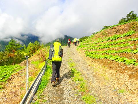
Photo: Richard Saunders
After a couple of sweaty hours’ climb, the trail follows the edge of cliffs, and the next section follows a very narrow ridge with sheer drops on either side, some impressive crags, and lots of fairly easy but eventually tiring rocky pitches to scramble up. It’s slow going, but here the mountain finally reveals its real character, with stunning rock formations, beautifully weathered coniferous trees hanging over vertiginous precipices, and panoramas over a huge expanse of rugged, unpopulated wilderness.
The wooded summit dome of Baigu Mountain is visible for some time before the trail climbs through a small patch of grassy meadow and begins the tough final slog to the top, up a huge and very steep boulder slope. It’s an exhausting climb — the toughest part perhaps of the whole trek, and strongly reminiscent of the climb to Yushan Front Peak, but even longer and steeper.
At the top, the mountain falls away precipitously on the far side, and following the narrow blade of the ridge, it’s less than five minutes to the trig point and a sublime, almost 360-degree view. To the north is the huge gorge of the Dajia River (大甲溪). To the west, several mountains of the Seven Heroes of Guguan (谷關七雄) can be seen, and beyond, the huge sprawl of Taichung spreads over the plains in the distance. We even fancy that we can see the sea in the slightly different shade of blue on the horizon.
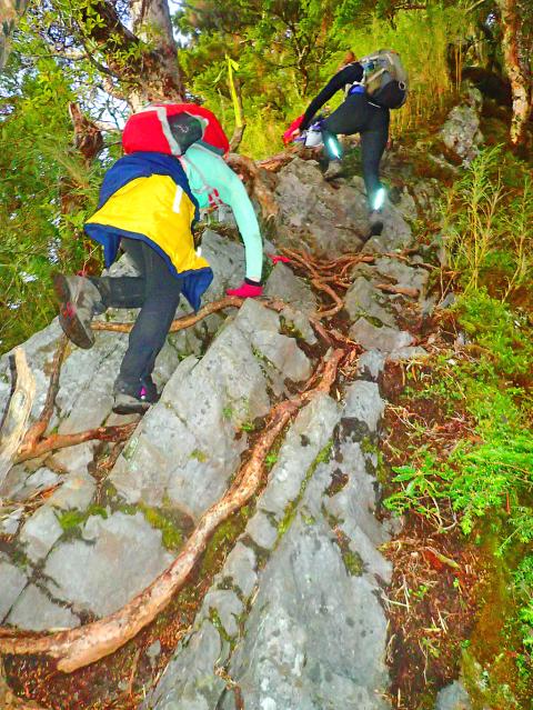
Photo: Richard Saunders
After a 3am start, trekkers should reach the summit between 7am and 8am. The day is still young, but don’t hang around if you hope to get back to the trailhead before dark — the return hike (including a few short rests, which you’ll definitely need) is a further 10 hours.
Richard Saunders is a classical pianist and writer who has lived in Taiwan since 1993. He’s the founder of a local hiking group, Taipei Hikers, and is the author of six books about Taiwan, including Taiwan 101 and Taipei Escapes. Visit his Web site at www.taiwanoffthebeatentrack.com.
If one asks Taiwanese why house prices are so high or why the nation is so built up or why certain policies cannot be carried out, one common answer is that “Taiwan is too small.” This is actually true, though not in the way people think. The National Property Administration (NPA), responsible for tracking and managing the government’s real estate assets, maintains statistics on how much land the government owns. As of the end of last year, land for official use constituted 293,655 hectares, for public use 1,732,513 hectares, for non-public use 216,972 hectares and for state enterprises 34 hectares, yielding
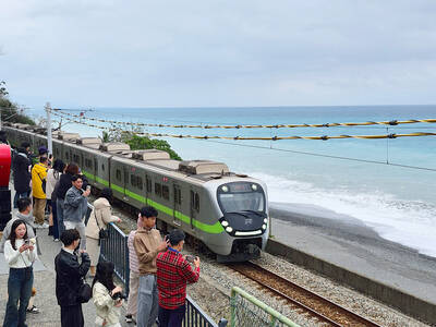
The small platform at Duoliang Train Station in Taitung County’s Taimali Township (太麻里) served villagers from 1992 to 2006, but was eventually shut down due to lack of use. Just 10 years later, the abandoned train station had become widely known as the most beautiful station in Taiwan, and visitors were so frequent that the village had to start restricting traffic. Nowadays, Duoliang Village (多良) is known as a bit of a tourist trap, with a mandatory, albeit modest, admission fee of NT$10 giving access to a crowded lane of vendors with a mediocre view of the ocean and the trains

The March/April volume of Foreign Affairs, long a purveyor of pro-China pablum, offered up another irksome Beijing-speak on the issues and solutions for the problems vexing the People’s Republic of China (PRC) and the US: “America and China at the Edge of Ruin: A Last Chance to Step Back From the Brink” rang the provocative title, by David M. Lampton and Wang Jisi (王緝思). If one ever wants to describe what went wrong with US-PRC relations, the career of Wang Jisi is a good place to start. Wang has extensive experience in the US and the West. He was a visiting

One of the challenges with the sheer availability of food in today’s world is that lots of us end up spending many of our waking hours eating. Whether it’s full meals, snacks or desserts, scientists have found that it’s not uncommon for us to be mindlessly grazing at some point during all of our 16 or so waking hours. The problem? As soon as this food hits the bloodstream in the form of glucose, it initiates the release of the hormone insulin. This in turn activates a switch present in every one of our cells, which is responsible for driving cell