Ongoing talks with Google Inc are being carried out to handle Google Earth imagery potentially leaking military secrets, the Ministry of National Defense said yesterday.
Four three-pronged structures were visible on the northwestern coast of Itu Aba Island (Taiping Island, 太平島) after the imagery was updated in July, but the ministry and the Coast Guard Administration have not commented on their nature.
Previous Google Earth images showed that the structures were not there in January last year.
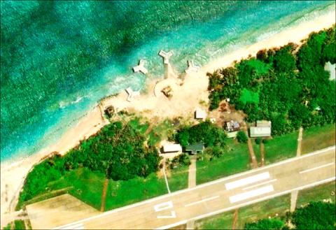
Photo: screengrab from Google Earth
The coast guard, which is in charge of Itu Aba, said that all structures and facilities on the island are classified and their functions could not be made known.
Satellite images on Google Earth show four structures on a claw-shaped base, with two of the four above the tideline, while all four structures have a dome-shaped object atop them.
A source said that as a new harbor on Itu Aba was completed at the end of last year, it was possible that the ministry supervised construction of the structures and forbade coast guard personnel from entering the area.
The structures are much larger than artillery bases that have been removed from the island, the source said.
Chinese Nationalist Party (KMT) Legislator Johnny Chiang (江啟臣) took photographs of the structures during a visit to the island in July, which showed they stood at least two stories high and were evidently not a giant surf break.
Ministry spokesman Chen Chung-chi (陳中吉) yesterday said that the facilities were classified and the ministry would not comment on the issue.
Minister of National Defense Feng Shih-kuan (馮世寬) said that while facilities and their functions on Itu Aba are classified, the public should rest assured that the island has strong defenses.
Coast Guard Director-General Lee Chung-wei (李仲威) said that details about the facility were classified and the administration had notified Google of the issue after KMT Legislator Alicia Wang (王育敏) asked Premier Lin Chuan (林全) whether the imagery on Google Earth could be used to discern what functions the facility had.
Netizens criticized the ministry and the coast guard’s reluctance to speak on the issue and said there are hundreds of satellites that could evidently see the structures, while others claiming to be “military experts” said the structures resembled anti-air gun turrets.
In other developments, the ministry denied reports that the Yun Feng missile program, a mid-range cruise missile developed by the state-run Chungshan Institute of Science and Technology, had been terminated by the administration of President Tsai Ing-wen (蔡英文).
The “Cloud Peak” missile program was said to be capable of hitting Beijing and Shanghai, with a range of more than 1,000km.
When asked whether the Tsai administration would terminate weapon systems capable of cross-strait strikes, Chen said that the ministry would outline its plans in January next year after it finalizes its strategic planning.

NATIONAL SECURITY: Authorities are working to confirm the identities of the military personnel involved and investigating possible illegal conduct and regulatory violations Authorities are probing possible national security implications after Kinmen police and immigration officers on Sunday found a Chinese woman allegedly posing as a tourist while engaging in prostitution involving more than 10 military personnel. The woman, surnamed Chen (陳), has since been deported, authorities said, adding that investigators are still working to confirm the identities of those implicated, as the records only listed code names and aliases. The case stemmed from a report received by the Kinmen District Prosecutors’ Office on Friday last week from the Jinhu Precinct of the Kinmen County Police Bureau. On Sunday, police, along with the National Immigration

GLOBALGIVING: ‘ Caving to external pressure is not acceptable for an organization that has cultivated justice reform and human rights for 30 years,’ one NGO said A slew of non-government organizations (NGOs) have withdrawn from the GlobalGiving fundraising platform after it announced it would use “Chinese Taipei” instead of “Taiwan” from next month. The Taiwan Good Rice Association wrote on Facebook on Friday that it was informed on April 28 via a teleconference call of the change, which was made because the platform wanted to operate in China. Taiwan Good Rice is to terminate all cooperative relationships with GlobalGiving in response to the platform’s “unilateral and non-negotiable” decision to remove references to Taiwan, the NGO said. “Taiwan is in the official name of Taiwan Good Rice Association and the

HEAVY WEATHER: Typhoon Jangmi is due to crash straight into the Ryukyus as airlines look to shift flights to larger aircraft or cancel flights to Okinawa entirely Taiwan’s international air carriers announced flight adjustments over the weekend as Typhoon Jangmi is forecast to hit the Ryukyu Islands today and tomorrow. The Central Weather Administration (CWA) upgraded Jangmi from a tropical storm to a typhoon at 8am yesterday, with the eye located 580km south of Naha city. It was moving north at 19kph. Today, China Airlines’ CI-120, CI-121, CI-122 and CI-123 flights between Taoyuan and Naha, Okinawa, have been canceled as well as CI-132 and CI-133 between Kaohsiung and Naha. EVA Air’s BR-112, BR-113, BR-186 and BR-185 flights between Taoyuan and Naha are also canceled. Low-cost carrier Tigerair Taiwan canceled IT-230,

Chinese Nationalist Party (KMT) Chairwoman Cheng Li-wun (鄭麗文) yesterday briefed her party’s Central Standing Committee regarding her scheduled visit to the US between Monday next week and June 16, saying that her purpose would be to persuade the US that the Republic of China (ROC) Constitution was a “one China” constitution that would foster stable and peaceful cross-strait relations. The ROC Constitution is the most important defense for all Taiwanese citizens, as it upholds our democracy and has contributed to our robust economy, which aligns with international and US interests, she said. “We would not be troublemakers and drag the US under,”