Satellite images released on Tuesday demonstrated just how powerful the floods and mudslides unleashed by Typhoon Morakot in southern Taiwan were.
One of the most stunning images obtained by National Central University’s Center for Space and Remote Sensing Research shows the widening of the Taimali River (太麻里溪) in Taitung County.
The images showed that the upper stream of the river, which is normally approximately 10m wide, has spread to more than 800m, due in part to the large volume of mud and debris washed down from the mountain.
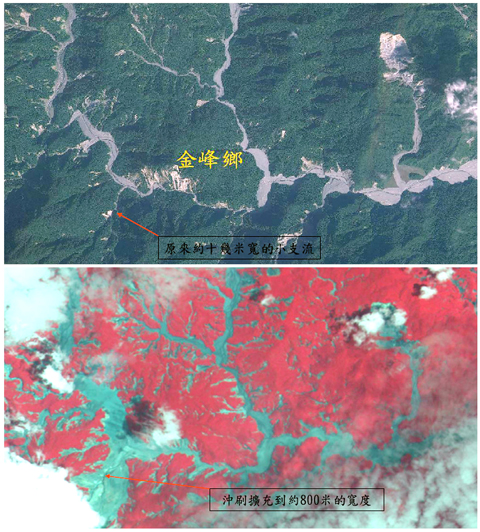
PHOTO: REUTERS
Chang Chung-pai (張中白), an associate professor at the center, said the mudslides observed in the wake of Morakot have been the largest on record.
“Mudflows observed in the past usually filled about 10km of the river,” he said of the 31km-long river.
“But the entire length of the Taimali River was filled with mudflows during this typhoon,” Chang said.
He said both the toppled Jinshuai Hotel in Taitung’s Jhihben (知本) hotspring area and the collapsed Shuangyuan Bridge (雙園大橋) in Kaohsiung County were located on the outer edge of a river bend, where the water’s momentum and erosive potential are the strongest.
Comparing the satellite images of the bridge taken on Jan. 14 and on Tuesday, the center found that the bridge broke up over the west side of the Gaoping River (高屏溪), the point where the water was deeper and the flow faster.

EXCUSES: Beijing is using government and research vessels as a pretext to harass the nation and enter its EEZ, and engage in ‘hegemonic expansion,’ the coast guard said The Coast Guard Administration yesterday said it drove away Chinese oceanographic research vessel Xiang Yang Hong 22 (向陽紅33) from restricted waters after warning it that it was in Taiwan’s exclusive economic zone (EEZ). The Chinese vessel entered restricted waters off the coast of Yilan County’s Suao (蘇澳) at 11:35pm on Thursday, the coast guard said, adding that it dispatched the Lanyu patrol vessel and the boat PP-10077 to shadow the Chinese ship and issue radio warnings ordering it to leave. China has no sovereignty over waters off Taiwan’s east coast, Lanyu’s crew told Xiang Yang Hong 22 over the radio, and demanded
Tropical Storm Mekkhala is forecast to strengthen into a typhoon tomorrow and could come close enough to Taiwan later in the week to prompt a sea warning, the Central Weather Administration (CWA) said yesterday. As of 2 pm, the storm was located 1,870 kilometers southeast of Taiwan's southern tip and moving west- northwest at 23 km per hour. CWA forecaster Cheng Chieh-jen (鄭傑仁) said Mekkhala is expected to continue moving west-northwest through Tuesday under the influence of the Pacific high- pressure system before gradually turning north toward waters east of Taiwan or south of the Ryukyu Islands. The timing and angle of the

Four Taiwanese universities have been ranked among the world's top 200 institutions in the Quacquarelli Symonds (QS) World University Rankings for next year, the highest Taiwan has ever placed in the category, with National Taiwan University (NTU) achieving its best performance at 54th globally and 17th in Asia. The four Taiwanese institutions in the global top 200 are NTU (54th), National Tsing Hua University (142nd), National Yang Ming Chiao Tung University (177th) and National Cheng Kung University (191st), the rankings showed. All four universities achieved their highest-ever global rankings this year, QS data showed. National Cheng Kung University entered the top 200 for

RISING POPULARITY: Enhanced flight connectivity and a visa waiver trial program are among the motivations that have boosted travel to Taiwan by Filipinos, the agency said The Tourism Administration said yesterday that it is stepping up efforts to attract tourists from the Philippines following strong growth during the first quarter. The agency’s data showed the nation welcomed 210,000 Filipino visitors from January to March, marking a 43 percent increase compared with the same period last year. The Philippines is Taiwan’s top source of inbound tourists among the Southeast Asian nations, data showed. With a population of 116 million and national median age of 26, the Philippines boasts a young demographic with strong travel potential, the Tourism Administration said. Outbound travel demand in the Philippines continues to rise amid robust