US surveillance aircraft and naval ships have yet to test China’s territorial claims around artificial islands built in the South China Sea, but the Pentagon on Thursday warned that could be “the next step.”
Although the US does not recognize China’s claims of sovereignty around the artificial structures, US P-8 surveillance planes and naval vessels patrolling the area have not ventured within 12 nautical miles (22km) of the artificial islands, the standard territorial zone around natural land.
“That would be the next step,” Pentagon spokesman Colonel Steven Warren told reporters.
Asked if the military would move to within that sensitive zone, he said: “We don’t have any announcement to make on next steps. We are going to continue our routine flights.”
US officials have said they are weighing sending warships and surveillance aircraft within 12 nautical miles of the artificial islands in the South China Sea to test Beijing’s controversial territorial claims.
However, the move could raise tensions and lead to a standoff on the high seas — in an area vital to global shipping lanes.
Beijing regards almost the whole of the South China Sea as its own.
The US Navy has released video from a P-8 Poseidon surveillance flight in the South China Sea that received several warnings from the Chinese military.
It showed a flotilla of vessels carrying out reclamation work in one lagoon and an airstrip under construction on another island.
“You can see here the landing strip and on the back side there is the taxiway,” an officer says, pointing at a screen, adding that “hundreds of meters” have been built in “the past couple of months.”
The officer said there was a huge dredging operation, taking material from the seabed as part of the reclamation project to provide fresh space for construction.
The new video came after a CNN television crew aboard a P-8 Poseidon plane captured a tense radio exchange between the US aircraft and Chinese forces in the area.
“This is the Chinese navy... This is the Chinese navy... Please go away... to avoid misunderstanding,” a voice can be heard telling the Americans.
The Chinese navy issued eight such warnings during the P-8’s flight near the Fiery Cross Reef (Yongshu Reef, 永暑礁) — which Taiwan also claims — one of the sites of Beijing’s massive land reclamation effort, CNN reported.
US pilots replied in each case that they were flying through “international airspace.”
The Chinese warnings to the US aircraft are typical and occur frequently, a US navy official said.
“It’s not uncommon,” the official said, adding that the Chinese sometimes send military aircraft to visually identify US planes in the area.
China’s Global Times newspaper said in an editorial that the access given to CNN showed that the US was “trying to sensationalize China’s reclamation activities on some reefs and islets in the South China Sea in a bid to impose more pressure on China.”
“Washington is purposefully raising tensions with China, a move that has created a higher risk of a physical confrontation between both sides,” it added.
With Beijing pursuing land reclamation at an unprecedented pace, a US naval commander has accused China of building a “great wall of sand” in the South China Sea to bolster its territorial claims.
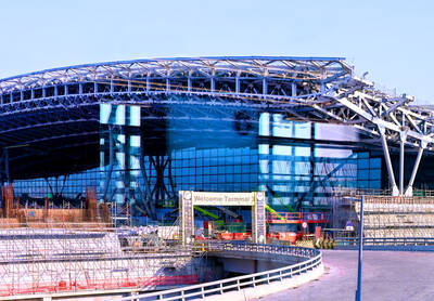
‘NO SECURITY RISK’: The Railway Bureau reassured the public that the technicians’ activities were limited to technical guidance and did not involve sensitive systems The Railway Bureau yesterday said it had invited eight Chinese technicians to assist with an airport MRT construction project. The bureau issued the confirmation after an Internet user said Chinese nationals had entered the construction zone of Taiwan Taoyuan International Airport’s Terminal 3 project. They asked why “individuals from an enemy state” were allowed access to such a major national infrastructure project, which raised serious concerns over Taiwan’s industrial safety, sensitive systems and information security. The bureau’s Northern Region Engineering Branch Office said subcontractor Taiwan Handle Industrial Co (台灣手把工業) of the Taoyuan airport MRT’s “Contract No. CU05 Project A14 Station Civil, MEP &
A US uncrewed surface vessel (USV) encountered multiple Chinese warships during an autonomous transit of the Taiwan Strait, US defense company Seasats said in a statement on Wednesday. Seasats announced that a Lightfish USV had completed the first autonomous transit of the Taiwan Strait. Over five days, the USV traversed the entire length of the Strait while constantly monitoring surface vessel traffic, the company said. The Lightfish encountered multiple Chinese warships, one of which was a Chinese People’s Liberation Army Navy (PLAN) Type 056 corvette, it said. The Chinese vessels were operating “well within Taiwan’s exclusive economic zone without transmitting their identity via the

GREATER REACH? Auto parts and wood products would face tariffs of up to 15%, matching those targeting the EU, Japan and South Korea, Vice Premier said The US has announced that preferential tariff treatment for Taiwan’s non-semiconductor Section 232 goods would take effect retroactively from May 1, the Executive Yuan said yesterday. The US government yesterday posted a notice on the Federal Register’s public inspection Web site previewing tariff concessions for Taiwan under a memorandum of understanding (MOU) on Taiwan-US investment after two months of negotiations. The MOU signed on Jan. 15 stipulated three major preferential tariff arrangements: a 15 percent “reciprocal” tariff rate for Taiwan without stacking most-favored nation (MFN) rates; preferential Section 232 treatment for semiconductors and related products; and preferential Section 232 treatment for non-semiconductor
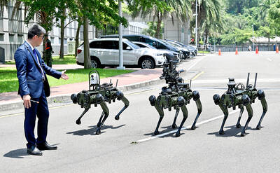
The National Chungshan Institute of Science and Technology yesterday showcased its locally developed variants of the Vision 60 robotic patrol dog, which it plans to deploy on the nation’s outlying territories in the South China Sea. The variants were produced under the Joint Lab project — created by the institute and domestic companies — and assembled with domestically produced motors, lenses and artificial intelligence (AI) systems alongside licensed tech from the US, Missile and Rocket Systems Research Division deputy director Jen Kuo-kang (任國光) told the media event at a military base in Taipei’s Dazhi (大直) area. Taiwan has built up its strengths