Palestinian militants are using Google Earth to help plan their attacks on the Israeli military and other targets.
Members of the al-Aqsa Martyrs Brigade, a group aligned with the Fatah political party, say they use the popular internet mapping tool to help determine their targets for rocket strikes.
"We obtain the details from Google Earth and check them against our maps of the city center and sensitive areas," said Khaled Jaabari, the group's chief in Gaza who is known as Abu Walid.
Abu Walid showed the Guardian an aerial image of the Israeli town of Sderot on his computer to show how his group searches for targets. The Guardian filmed an al-Aqsa test rocket launch, fired into an uninhabited area of the Negev desert, last month.
Many of the rockets have landed in Sderot, killing around a dozen people in the last three years and wounding scores more.
Al-Aqsa is one of several militant groups firing rockets, known as Qassams, from Gaza into Israel. A rocket attack by Islamic Jihad on a military base last month wounded more than 50 soldiers.
Abu Walid insists there is no contradiction between his group's actions and talk of peace by Palestinian President Mahmoud Abbas, Fatah's leader.
Bringing up archive footage of rocket launches on his computer, Abu Walid said that the group had modified the rockets to travel longer distances by cultivating salt from the sea, adding: "It's a secret process, but we're very excited by the results."
The Google Earth mapping program includes satellite maps and detailed 3D models of some areas. Although the satellite images are only updated on an irregular basis -- meaning that pictures of mobile targets would be unusable -- some defense experts have said the easy availability of information can increase the risks for military organizations.
"There is a constant threat of reconnaissance missions to access our bases and using these Internet images is just another method of how this is conducted," Major Charlie Burbridge, a British military spokesman, said earlier this year.
In January, UK officials said insurgents sympathetic to al-Qaeda were using aerial photography in Google Earth to locate potential targets inside British bases around the southern Iraqi city of Basra.
"We have paid close attention to concerns that Google Earth creates new security risks," Google said in a statement. "The imagery visible on Google Earth and Google Maps is not unique: commercial high-resolution satellite and aerial imagery of every country in the world is widely available from numerous sources."
Also See: Israel orders new sanctions on Gaza
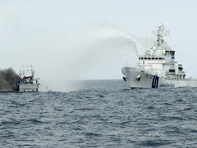
CREDIT-GRABBER: China said its coast guard rescued the crew of a fishing vessel that caught fire, who were actually rescued by a nearby Taiwanese boat and the CGA Maritime search and rescue operations do not have borders, and China should not use a shipwreck to infringe upon Taiwanese sovereignty, the Coast Guard Administration (CGA) said yesterday. The coast guard made the statement in response to the China Coast Guard (CCG) saying it saved a Taiwanese fishing boat. The Chuan Yu No. 6 (全漁6號), a fishing vessel registered in Keelung, on Thursday caught fire and sank in waters northeast of Diaoyutai Islands (釣魚台). The vessel left Keelung’s Badouzih Fishing Harbor (八斗子漁港) at 3:35pm on Sunday last week, with seven people on board — a 62-year-old Taiwanese captain surnamed Chang (張) and six
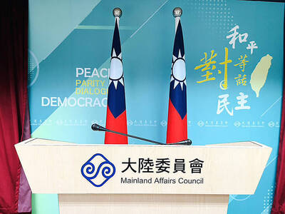
RISKY BUSINESS: The ‘incentives’ include initiatives that get suspended for no reason, creating uncertainty and resulting in considerable losses for Taiwanese, the MAC said China’s “incentives” failed to sway sentiment in Taiwan, as willingness to work in China hit a record low of 1.6 percent, a Ministry of Labor survey showed. The Directorate-General of Budget, Accounting and Statistics (DGBAS) also reported that the number of Taiwanese workers in China has nearly halved from a peak of 430,000 in 2012 to an estimated 231,000 in 2024. That marked a new low in the proportion of Taiwanese going abroad to work. The ministry’s annual survey on “Labor Life and Employment Status” includes questions respondents’ willingness to seek employment overseas. Willingness to work in China has steadily declined from

The Legislative Yuan’s Finance Committee yesterday approved proposed amendments to the Amusement Tax Act (娛樂稅法) that would abolish taxes on films, cultural activities and competitive sporting events, retaining the fee only for dance halls and golf courses. The proposed changes would set the maximum tax rate for dance halls and golf courses at 50 and 20 percent respectively, with local governments authorized to suspend the levies. Article 2 of the act says that “amusement tax shall be levied on tickets sold or fees charged by amusement places, facilities or activities” in six categories: “Cinema; professional singing, story-telling, dancing, circus, magic show, acrobatics
INFLATION UP? The IMF said CPI would increase to 1.5 percent this year, while the DGBAS projected it would rise to 1.68 percent, with GDP per capita of US$44,181 The IMF projected Taiwan’s real GDP would grow 5.2 percent this year, up from its 2.1 percent outlook in January, despite fears of global economic disruptions sparked by the US-Iran conflict. Taiwan’s consumer price index (CPI) is projected to increase to 1.5 percent, while unemployment would be 3.4 percent, roughly in line with estimates for Asia as a whole, the international body wrote in its Global Economic Outlook Report published in the US on Monday. The figures are comparatively better than the IMF outlook for the rest of the world, which pegged real GDP growth at 3.1 percent, down from 3.3 percent