It was like finding a cherished photo album that I thought I’d lost forever. The news that one of the most scenic sections of the South Cross-Island Highway (南橫公路) had finally reopened was the best I’d heard all week.
Until Typhoon Morakot wreaked havoc in the summer of 2009, the highway had provided a reliable connection between the southwest and the east, at least during the dry season. For Tainan residents driving to Hualien, Highway 20 (the road’s official designation) was a quicker and more enjoyable alternative to the South Link Highway (南迴公路) from Pingtung to Taitung.
Back in the 1990s, my friends and I often rode the early morning bus from Tainan to Kaohsiung’s Tianchi (天池), and not just to ogle the landscape. Tianchi, at an elevation 2,280m, is within walking distance of some superb hiking trails, including those to the summits of Guanshan (關山, 3,666m) and Taguanshan (塔關山, 3,222m).
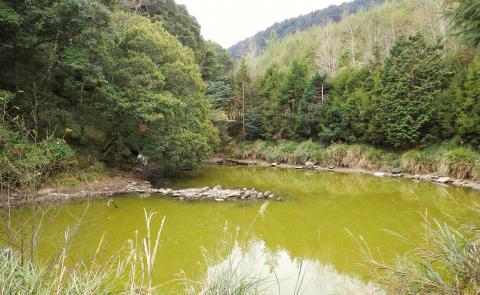
Photo: Steven Crook
Once we walked from Tianchi, through Daguanshan Tunnel (大關山隧) — at 2,722m the highest point of the highway — and all the way to the village of Lidao (利稻) in Taitung County’s Haiduan Township (海端鄉). I’ve especially fond memories of seeing wildlife on Yakou Forestry Road (埡口林道). At the best of times, the forestry road was scarred by landslides; I suspect it was obliterated by Morakot.
On the Taitung side, the road has long been open as far as Siangyang (向陽). For most of the past decade, however, the high-altitude section of Highway 20 on the Kaohsiung side was off-limits to the public. A checkpoint just outside Meishankou (梅山口, elevation 1,014m) in Kaohsiung’s Taoyuan District (桃源區) stopped outsiders from going any further inland. A few intrepid hikers and cyclists found ways around this barrier and exited via Siangyang.
The checkpoint still exists, but since Jan. 12 it’s been possible to drive a car or ride a motorcycle as far as Tianchi, as long as you do so between 8am and 1pm. You should return to Meishankou by 3pm. No pen-and-paper registration is required. Instead, each vehicle must stop for a moment so its license plate can be photographed.

Photo: Steven Crook
According to the Liberty Times (the Taipei Times’ sister newspaper), on the first day of reopening, more than 700 vehicles went through the checkpoint. A month later and in the middle of the working week, we reached Meishankou — 108km from central Tainan and slightly further from central Kaohsiung — just before the 1pm cutoff. We found a packed parking lot and vendors doing a roaring trade, but no delays at the checkpoint.
Moving cautiously uphill, we quickly realized we were in for a difficult drive. The morning crowds were heading home; almost all of the traffic was coming in the opposite direction. On a wide and straight highway, I’d have considered that a blessing. On a twisting mountain road where passing is often difficult, it was stressful.
Meishankou to Tianchi is 25km, but after covering less than 6km, we decided to turn around and return the following morning. Because Meishan Youth Activity Center (梅山青年活動中心) was booked, we spent the night in a homestay in Meilan (梅蘭), 4km to the south. Like several other villages along Highway 20, such as Meishankou and Lidao, most of the people in Meilan are members of the Bunun (布農) Aboriginal community.

Photo: Steven Crook
The following morning, we passed through the first checkpoint just before 8:30am and drove nonstop to Tianchi. There was no holdup at the second checkpoint, 10km from Meishankou and also equipped with a camera. Two dozen motorcycles were parked at Tianchi. Visitors aren’t allowed any further up the road, even on foot.
To find a parking spot, we had to turn around and go downhill a short distance. From there, it was less than 10 minutes’ walk to the stairs up to Changqing Shrine (長青祠). The shrine, which was built in 1979 as a memorial to the 116 workers who died constructing the South Cross-Island Highway, is an unremarkable structure — yet the views from it are glorious.
Patches of snow speckled the mountains nearby. We could see most of the highway between Tianchi and Daguanshan Tunnel, and hear earthworks in progress. It’s said that the entire road could reopen in 2022. It depends, of course, on the severity of any typhoons between now and then.

Photo: Steven Crook
Some tourists park near Tianchi so they can hike the Jhongjhiguan Trail (中之關步道). This flattish 3.5km-long path loops back to a small parking lot on the South Cross-Island Highway. Hikers who haven’t arranged to be collected at the other end need to walk back the way they came, thumb a lift to their vehicle or tramp 4.9km along the road.
We were content to walk another 10 minutes to see the feature which gives Tianchi (“heaven’s pond”) its name.
This body of brown-green water is neither large nor especially attractive, but something about it draws a certain type of Buddhist. Long before Morakot, the authorities posted signs reminding outsiders that fangsheng (放生, the “merciful release” of captive creatures into the wild to accrue merit) is prohibited.
The fish I saw in the pond looked like koi; I’ve no idea if the tadpoles represented an invasive species. But up here, no doubt, humanity is by far the worst intruder. If the South Cross-Island Highway didn’t already exist, would any 21st-century government think such a road is necessary?
Steven Crook has been writing about travel, culture, and business in Taiwan since 1996. He is the co-author of A Culinary History of Taipei: Beyond Pork and Ponlai, and author of Taiwan: The Bradt Travel Guide, the third edition of which has just been published.
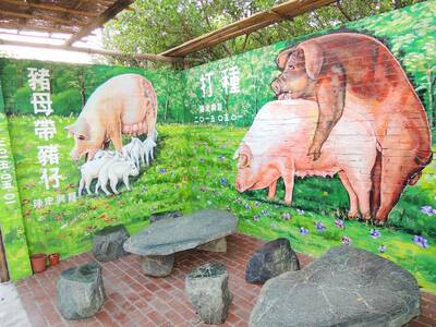
May 6 to May 12 Those who follow the Chinese-language news may have noticed the usage of the term zhuge (豬哥, literally ‘pig brother,’ a male pig raised for breeding purposes) in reports concerning the ongoing #Metoo scandal in the entertainment industry. The term’s modern connotations can range from womanizer or lecher to sexual predator, but it once referred to an important rural trade. Until the 1970s, it was a common sight to see a breeder herding a single “zhuge” down a rustic path with a bamboo whip, often traveling large distances over rugged terrain to service local families. Not only

Ahead of incoming president William Lai’s (賴清德) inauguration on May 20 there appear to be signs that he is signaling to the Chinese Communist Party (CCP) and that the Chinese side is also signaling to the Taiwan side. This raises a lot of questions, including what is the CCP up to, who are they signaling to, what are they signaling, how with the various actors in Taiwan respond and where this could ultimately go. In the last column, published on May 2, we examined the curious case of Democratic Progressive Party (DPP) heavyweight Tseng Wen-tsan (鄭文燦) — currently vice premier
The last time Mrs Hsieh came to Cihu Park in Taoyuan was almost 50 years ago, on a school trip to the grave of Taiwan’s recently deceased dictator. Busloads of children were brought in to pay their respects to Chiang Kai-shek (蔣中正), known as Generalissimo, who had died at 87, after decades ruling Taiwan under brutal martial law. “There were a lot of buses, and there was a long queue,” Hsieh recalled. “It was a school rule. We had to bow, and then we went home.” Chiang’s body is still there, under guard in a mausoleum at the end of a path

Last week the Directorate-General of Budget, Accounting and Statistics (DGBAS) released a set of very strange numbers on Taiwan’s wealth distribution. Duly quoted in the Taipei Times, the report said that “The Gini coefficient for Taiwanese households… was 0.606 at the end of 2021, lower than Australia’s 0.611, the UK’s 0.620, Japan’s 0.678, France’s 0.676 and Germany’s 0.727, the agency said in a report.” The Gini coefficient is a measure of relative inequality, usually of wealth or income, though it can be used to evaluate other forms of inequality. However, for most nations it is a number from .25 to .50