Beigan (北竿), Matsu’s second largest island, is best known for Qinbi (芹壁), a beautiful old village of stone houses clinging to a steep hillside beside the ocean.
Qinbi is Matsu’s biggest tourist attraction, and the main reason why most Taiwanese visitors go to Matsu. Qinbi is a compulsory stop on any visit to Beigan, but as always on these enchanted islands, there are plenty of less well-known natural and man-made attractions to enjoy, including an amazing underground harbor, Matsu’s best museum, as well as grander and wilder scenery than nearby Nangan Island (南竿島).
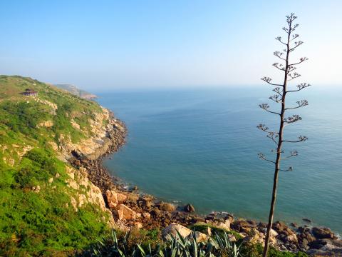
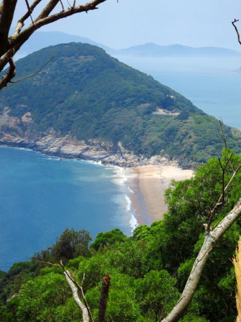
Photo: Richard Saunders
While you should visit at least one other island in the group to get a proper feel for life in this unique chain of islands, Beigan is as good a place as any to enjoy both the great outdoors and to learn a bit about Matsu’s turbulent past.

The easiest way to reach Beigan is by plane from Taipei, but I prefer to arrive from neighboring Nangan by boat (15 minutes), which better sets the scene for Beigan’s very slow, relaxed pace of life. Boats arrive at Baishi Harbor (白沙港) in the south of the island, and scooters can be rented from several places here. Take care, however, when hiring a scooter on any of Matsu’s islands. Happily, the scooters are generally of far better quality now than just a few years ago, when the average one was old and battered, and often had brakes that were borderline dangerous on Matsu’s sometimes very steep hills.

The problem nowadays is that there’s a lively (even cut-throat) competition between scooter hire outfits and hotels. If you already have accommodation booked when you arrive on the island, call the hotel ahead to arrange a lift, and then hire the scooter direct from them, to avoid possible conflicts later. Be sure to always wear your scooter helmet when driving. On my last visit earlier this month, a hotel owner warned me that frustrated scooter hire outfits, fed-up with lost business, were reporting tourists riding without helmets to the police, and getting them fined.
CRUISING THE COAST
Leaving the harbor by the coast road heading north, a long, mountainous sweep of China’s coast is clearly visible in clear weather. Pass Banli Beach (?里海灘), Beigan’s largest, but strewn with small rocks, and a little further along the coast is Beihai Tunnel (北海坑道), dug (like its counterparts on Nangan and Dongyin islands) in an amazingly short time with nothing more than dynamite, simple tools and a huge amount of blood sweat and tears.
Over a hundred soldiers died during the construction of the tunnel, and the area is said to be haunted. It’s a very impressive sight, but was unfortunately “temporarily” closed a year or two back, apparently because the roof is unstable. Leaving Banli, the main road climbs high above the ocean. Take a left at the junction and the road climbs steeply to the top of Mount Bi (壁山), the highest point on the Matsu islands at 298 meters. A viewing platform beside the road gives a magnificent bird’s eye panorama over the eastern half of Beigan.
Below Mount Bi, on the west coast of the island, the famous, much photographed old village of Qinbi (established during the Qing Dynasty) is the best preserved and most complete stone house village in Matsu. It’s best approached from the south, where the first view of it is utterly charming. Unfortunately, some thoughtless development (such as the hideous tile-walled high school buildings) has spoiled the beauty of the scene, and some new faux-traditional impostors (built of brick, with a thin facing of stone) were built a couple of years ago, presumably to satisfy the growing demand for homestays in the village.
Despite this, Qinbi is the nicest place to stay on the island, with a number of homestays (book early). If the homestays are full, try at least to enjoy a leisurely drink or snack at one of the village’s two cafes, which both have large, open terraces. From here, the view of the granite houses tumbling down the hillside to the still, blue-green waters of the bay and the low dome of Turtle Island just offshore, is quite magical. Look further out to sea, and the coast of China is visible in the distance.
THE VILLAGE OF TANGQI
Next to the island’s airport, Tangqi (塘岐), is Beigan’s largest village, with the best selection of accommodation, eating options and shops. A couple of eateries in the main street sell Matsu’s famous fish noodles (魚麵; flaked fish is incorporated into the noodle dough), but although eating a bowl is de rigueur for local tourists, they’re nothing special.
Pass through the tunnel under the airport runway, and cross the long sandbar that joins Beigan to little Houao Islet (后沃). Despite being rudely bisected by the airport, the remaining sweep of sugar sand is a great place for a paddle.
Passing through Matsu’s only traffic light, the road climbs steeply onto the heights of Houao. At the top is the War and Peace Memorial Park (軍事和平紀念公園). Turn left and follow the road to Stronghold no. 6, which lies in a magnificent setting at the northern tip of the island. The tunnels of the stronghold wind through the rock, emerging at several gun emplacements looking out over the sea. From the end, sets of steps descend towards the rocky foreshore, and climb back up the cliffs. Further south, the War and Peace Memorial Park Exhibition Hall (戰爭和平紀念公園主題館) gives a detailed rundown (in English) of the island’s tumultuous recent history.
The exhibition hall is at the trailhead of one of Matsu’s finest hikes, the Luoshan Nature Trail (螺山自然步道). This short walk (less than an hour each way) has magnificent views, and ends at an observation platform overlooking the channel between Houao and Luoshan islets, and a small rock stack known as Confucius on the Sea. This wild and beautiful spot is one of Beigan’s most exhilarating spots, and a quiet place to lap up a view that encompasses the whole length of Beigan Island.
Richard Saunders is a classical pianist and writer who has lived in Taiwan since 1993. He’s the founder of a local hiking group, Taipei Hikers, and is the author of six books about Taiwan, including Taiwan 101 and Taipei Escapes. Visit his Web site at www.taiwanoffthebeatentrack.com.
The problem with Marx’s famous remark that history repeats itself, first as tragedy, the second time as farce, is that the first time is usually farce as well. This week Chinese Nationalist Party (KMT) Chair Cheng Li-wun (鄭麗文) made a pilgrimage to the People’s Republic of China (PRC) “to confer, converse and otherwise hob-nob” with Chinese Communist Party (CCP) officials. The visit was an instant international media hit, with major media reporting almost entirely shorn of context. “Taiwan’s main opposition leader landed in China Tuesday for a rare visit aimed at cross-strait ‘peace’”, crowed Agence-France Presse (AFP) from Shanghai. Rare!

What is the importance within the Chinese Nationalist Party (KMT) of the meeting between Xi Jinping (習近平), the leader Chinese Communist Party (CCP), and Cheng Li-wun (鄭麗文), the leader of the KMT? Local media is an excellent guide to determine how important — or unimportant — a news event is to the public. Taiwan has a vast online media ecosystem, and if a news item is gaining traction among readers, editors shift resources in near real time to boost coverage to meet the demand and drive up traffic. Cheng’s China trip is among the top headlines, but by no means

Sunflower movement superstar Lin Fei-fan (林飛帆) once quipped that the Democratic Progressive Party (DPP) could nominate a watermelon to run for Tainan mayor and win. Conversely, the DPP could run a living saint for mayor in Taipei and still lose. In 2022, the DPP ran with the closest thing to a living saint they could find: former Minister of Health and Welfare Chen Shih-chung (陳時中). During the pandemic, his polling was astronomically high, with the approval of his performance reaching as high as 91 percent in one TVBS poll. He was such a phenomenon that people printed out pop-up cartoon
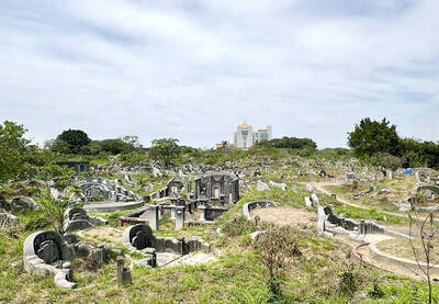
Apr. 13 to Apr. 19 From 17th-century royalty and Presbyterian missionaries to White Terror victims, cultural figures and industrialists, Nanshan Public Cemetery (南山公墓) sprawls across 95 hectares, guarding four centuries of Taiwan’s history. Current estimates show more than 60,000 graves, the earliest dating to 1642. Besides individual tombs, there are also hundreds of family plots, one of which is said to contain around 1,000 remains. As the cemetery occupies valuable land in the heart of Tainan, the government in 2018 began asking families to relocate the graves to make way for development. That