The Central Weather Administration (CWA) today placed Taipei and New Taipei City under extremely heavy rain or torrential rain advisories, warning of intense rainfall throughout the day.
The agency defines "extremely heavy rain" as accumulated rainfall of 200mm or more within 24 hours, or 100mm or more within three hours.

Photo: Taipei Times
"Torrential rain" refers to accumulated rainfall of 350mm or more in 24 hours, or more than 200mm within three hours.
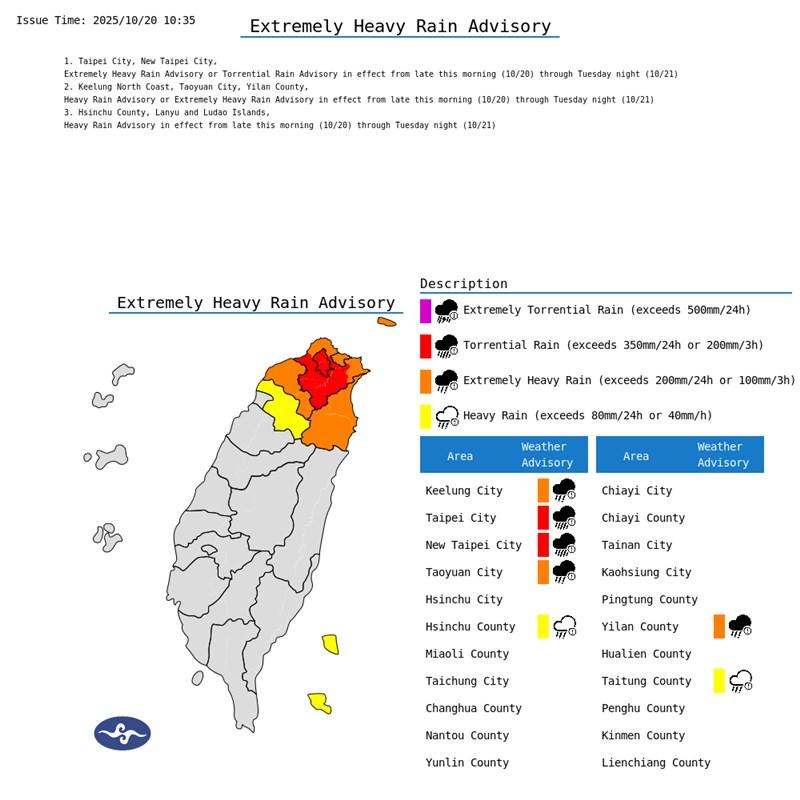
Photo courtesy of the Central Weather Administration
According to the CWA Web site, the location in Taiwan that saw the highest levels of accumulated rainfall between yesterday and 7am today was Nangang District (南港) in Taipei, which was soaked with 291.5mm of rain.
Following Nangang was New Taipei City's Shiding District (石碇), which accumulated 287.5mm of rainfall in the same duration, CWA data showed.
The CWA said that due to the effects of seasonal northeasterly winds and the outer bands of Tropical Storm Fengshen, it also issued heavy rain or extremely heavy rain advisories for Taoyuan, the Keelung north coast and Yilan County.
Additionally, the CWA placed Hsinchu and Taitung counties under heavy rain advisories, warning of the possibility of rainfall exceeding 40mm in an hour or 80mm in 24 hours.
Besides Hsinchu and Taitung, the CWA warned Orchid (Lanyu, 蘭嶼) and Green (綠島) islands of localized heavy rain today.
The CWA said that the rain alerts would stay in effect between this morning and tomorrow night, urging residents of the locations to be aware of sudden heavy rainfall and strong winds.
The agency advised residents in low-lying areas to be alert for potential flooding, while those in mountainous regions should watch out for landslides, mudslides, and sudden rises in river and stream levels.
Independent meteorologist Wu Der-rong (吳德榮) also warned of heavy rain from today to Wednesday, echoing the CWA's advisories for northern and northeastern Taiwan over the next two days.
Wu said that the heavy rain comes from the combined effects of seasonal northeasterly winds and Tropical Storm Fengshen.
As of 8am today, Fengshen's center was about 610km southwest of Cape Oluanpi (鵝鑾鼻), Taiwan's southernmost point, moving west-southwest at a speed of 20kph, the CWA said.
Wu said the latest forecast projects the storm to move toward the eastern side of China's Hainan Island.
Fengshen is then expected to shift southwest, moving away from Taiwan and reaching the southern side of Hainan by Wednesday, Wu said.
Although the storm would move farther from Taiwan, moisture brought by seasonal northeasterly winds could still bring heavy to extremely heavy rain to northern and eastern Taiwan between Thursday and Friday, he said.

A drunk woman was sexually assaulted inside a crowded concourse of Taipei Railway Station on Thursday last week before a foreign tourist notified police, leading to calls for better education on bystander intervention and review of security infrastructure. The man, surnamed Chiu (邱), was taken into custody on charges of sexual assault, taking advantage of the woman’s condition and public indecency. Police discovered that Chiu was a fugitive with prior convictions for vehicle theft. He has been taken into custody and is to complete his unserved six-month sentence, police said. On Thursday last week, Chiu was seen wearing a white

EVA Airways, one of the leading international carriers in Taiwan, yesterday said that it was investigating reports that a cabin crew manager had ignored the condition of a sick flight attendant, who died on Saturday. The airline made the statement in response to a post circulating on social media that said that the flight attendant on an outbound flight was feeling sick and notified the cabin crew manager. Although the flight attendant grew increasingly ill on the return flight, the manager did not contact Medlink — a system that connects the aircraft to doctors on the ground for treatment advice during medical
The Taoyuan Flight Attendants’ Union yesterday vowed to protest at the EVA Air Marathon on Sunday next week should EVA Airway Corp’s management continue to ignore the union’s petition to change rules on employees’ leave of absence system, after a flight attendant reportedly died after working on a long-haul flight while ill. The case has generated public discussion over whether taking personal or sick leave should affect a worker’s performance review. Several union members yesterday protested at the Legislative Yuan, holding white flowers and placards, while shouting: “Life is priceless; requesting leave is not a crime.” “The union is scheduled to meet with

‘UNITED FRONT’ RHETORIC: China’s TAO also plans to hold weekly, instead of biweekly, news conferences because it wants to control the cross-strait discourse, an expert said China’s plan to expand its single-entry visa-on-arrival service to Taiwanese would be of limited interest to Taiwanese and is a feeble attempt by Chinese administrators to demonstrate that they are doing something, the Mainland Affairs Council said yesterday. China’s Taiwan Affairs Office (TAO) spokesman Chen Binhua (陳斌華) said the program aims to facilitate travel to China for Taiwanese compatriots, regardless of whether they are arriving via direct flights or are entering mainland China through Hong Kong, Macau or other countries, and they would be able to apply for a single-entry visa-on-arrival at all eligible entry points in China. The policy aims