China’s oceanographic survey and research ships are collecting data in the Indo-Pacific region — possibly to aid submarine navigation, detect or map undersea cables, and lay naval mines — activities that could have military applications in a conflict with Taiwan or the US, a New York Times report said.
The article, titled “China Surveys Seabeds Where Naval Rivals May One Day Clash,” was written by Chris Buckley and published on Thursday.
Starboard Maritime Intelligence data revealed that Chinese research ships last year repeatedly scanned the ocean floor east of Taiwan’s maritime border, and about 400km east and west of Guam; “waters that China’s navy considers strategically vital,” it said.
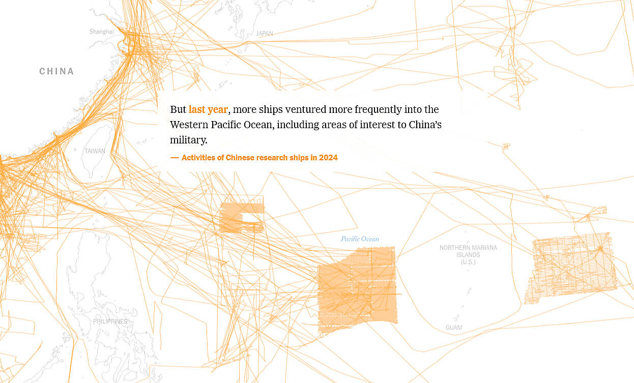
Photo: screengrab from New York Time’s Webpage
Last year, six research ships made 25 passes in parallel lines through the waters off Taiwan’s east coast, the article said.
Chinese ships frequently navigated close to Taiwan’s 12 nautical mile (22km) territorial sea boundary, but never crossed it, meaning Taipei could do little to object, it added.
They also moved in parallel lines and grid formations, “precise patterns that experts said suggested a methodical effort to collect information about the seabed that could, among other things, support military operations,” it said.
The majority of China’s research ships are civilian, run by government agencies, universities and institutes, which allows them to attract less attention and scrutiny than naval vessels, the article said.
Under international law, civilian research ships are allowed to operate in international waters and within other countries’ exclusive economic zones with permission, it said.
However, Ocean Affairs Council Minister Kuan Bi-ling (管碧玲) said that “it’s hard for us to view this situation as normal.”
“The potential military payoff from their research seemed clear,” the article said. “Taiwan’s eastern coast is home to key air and naval bases, and if war broke out, the Chinese navy would try to seize control of the nearby seas.”
Chinese military researchers in 2010 said that understanding the Kuroshio Current northeast of Taiwan would help China “better conceal ourselves and attack our enemies,” it added.
The article highlighted the extensive scope of China’s operations, with the Xiang Yang Hong No. 6 (向陽紅06) having surveyed the seabed surrounding Guam — a US territory that hosts US military forces — an area larger than the UK.
“The tracks are so tightly packed, and all this was done in one year. Clearly, they were doing a bathymetric survey,” said Sen Jan (詹森), a professor of oceanography at National Taiwan University.
Bathymetric surveys use technologies such as sonar to map the contours and features of the seabed.
The article said that the voyages might serve various scientific purposes, including mineral exploration, marine biodiversity research and assessing the effects of climate change. However, “the growing research fleet could give Beijing a powerful advantage in maritime competition with the United States,” it added.
“China’s expanding maritime reach deserves close scrutiny, especially its ‘research’ vessels that map seabeds, deploy sensors and pave way for submarine operations” the article quoted former Australian naval officer Jennifer Parker as saying.
Despite growing concerns, such activities have continued, it said, adding that just last month, the Xiang Yang Hong No. 1 (向陽紅01) and Xiang Yang Hong No.5 (向陽紅五號05) were observed operating in grid-like patterns east of Guam.

The military has spotted two Chinese warships operating in waters near Penghu County in the Taiwan Strait and sent its own naval and air forces to monitor the vessels, the Ministry of National Defense (MND) said. Beijing sends warships and warplanes into the waters and skies around Taiwan on an almost daily basis, drawing condemnation from Taipei. While the ministry offers daily updates on the locations of Chinese military aircraft, it only rarely gives details of where Chinese warships are operating, generally only when it detects aircraft carriers, as happened last week. A Chinese destroyer and a frigate entered waters to the southwest
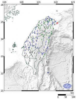
A magnitude 6.1 earthquake struck off the coast of Yilan County at 8:39pm tonight, the Central Weather Administration (CWA) said, with no immediate reports of damage or injuries. The epicenter was 38.7km east-northeast of Yilan County Hall at a focal depth of 98.3km, the CWA’s Seismological Center said. The quake’s maximum intensity, which gauges the actual physical effect of a seismic event, was a level 4 on Taiwan’s 7-tier intensity scale, the center said. That intensity level was recorded in Yilan County’s Nanao Township (南澳), Hsinchu County’s Guansi Township (關西), Nantou County’s Hehuanshan (合歡山) and Hualien County’s Yanliao (鹽寮). An intensity of 3 was

Japanese Prime Minister Sanae Takaichi’s comment last year on Tokyo’s potential reaction to a Taiwan-China conflict has forced Beijing to rewrite its invasion plans, a retired Japanese general said. Takaichi told the Diet on Nov. 7 last year that a Chinese naval blockade or military attack on Taiwan could constitute a “survival-threatening situation” for Japan, potentially allowing Tokyo to exercise its right to collective self-defense. Former Japan Ground Self-Defense Force general Kiyofumi Ogawa said in a recent speech that the remark has been interpreted as meaning Japan could intervene in the early stages of a Taiwan Strait conflict, undermining China’s previous assumptions

Taiwan Railways Corp (TRC) today announced that Shin Kong Mitsukoshi has been selected as the preferred bidder to operate the Taipei Railway Station shopping mall, replacing the current operator, Breeze Development Co Ltd. Among eight qualified firms that delivered presentations and were evaluated by a review committee, Shin Kong Mitsukoshi was ranked first, while Breeze was named the runner-up, the rail company said in a statement. Contract negotiations are to proceed in accordance with regulations, it said, adding that if negotiations with the top bidder fail, it could invite the second-ranked applicant to enter talks. Breeze in a statement today expressed doubts over