Back-to-back weather fronts are forecast to hit Taiwan this week, resulting in rain across the nation in the coming days, the Central Weather Administration said yesterday, as it also warned residents in mountainous regions to be wary of landslides and rockfalls.
As the first front approached, sporadic rainfall began in central and northern parts of Taiwan yesterday, the agency said, adding that rain is forecast to intensify in those regions today, while brief showers would also affect other parts of the nation.
A second weather system is forecast to arrive on Thursday, bringing additional rain to the whole nation until Sunday, it said.
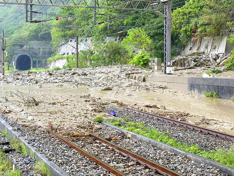
Photo courtesy of a reader
Former Weather Forecast Center director Daniel Wu (吳德榮), who is now an adjunct associate professor of atmospheric sciences at National Central University, said there is also an increased chance of lightning, strong winds and sudden downpours this week.
It started raining yesterday afternoon in northern areas of Hualien County, resulting in landslides that blocked the railway line between Chongde (崇德) and Heren (和仁), interrupting train services on the North-Link Line (北迴線), Taiwan Railway Corp said.
A slope collapse and rockfalls have blocked off both directions of railway tracks between Heren and Chongde, and rocks and debris are still falling down from the slopes of Provincial Highway No. 9 above the railway. Therefore excavators cannot move into the area and the blocked section would not be open as of late last night, it said.
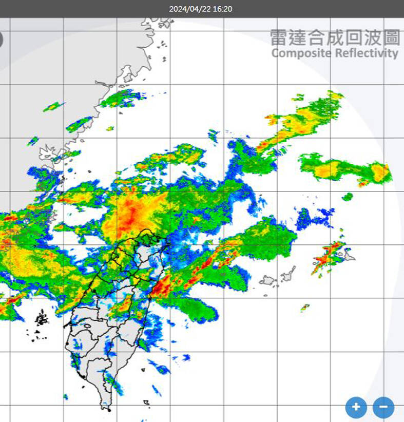
Photo: screen grab from the Central Weather Administration’s Web site
Starting at 4pm yesterday, train services from Taipei to Hualien and Taitung cities were canceled and express trains northbound from Taitung would terminate in Hualien City, it said.
Taiwan Railway Corp urged passengers to check its Web site, call its 24-hour service at (02) 2191-0096 or the toll-free line at 0800-765-888 for the latest information.
Travelers with tickets that were not used due to the slope collapse can apply for a refund within the next year, it added.
Meanwhile, more than five earthquakes ranging from magnitude 4.4 to 5.5 on the Richter scale shook eastern Taiwan in rapid succession late yesterday afternoon, continuing the unsettling roller-coaster ride Hualien County residents have been on since a magnitude 7.2 earthquake hit the county on April 3.
The biggest of the series, a magnitude 5.5 quake that hit at 5:08pm yesterday, occurred 26.8km south-southwest of Hualien County Hall at a depth of 10km, the Central Weather Administration said.
A magnitude 4.4 quake centered in Shoufeng Township (壽豐) occurred a minute later at a depth of 9.5km, the agency said.
It was followed by earthquakes of magnitudes 5.3, 4.9 and 4.9 at 5:12pm, 5:15pm and 5:17pm, again centered in the township, the agency added.
They were all relatively shallow, occurring at depths of 10km, 5.4km and 2.8km respectively.
Seismological Center Director Wu Chien-fu (吳健富) said the series of shallow quakes were aftershocks of the April 3 earthquake.
Wu said that the frequency and number of aftershocks have generally abated, despite yesterday’s activity, but he expects more aftershocks, mostly of magnitude 3 and occasionally magnitude 4.

A signaling system malfunction disrupted high-speed rail (HSR) services beginning at 8am today, with trains temporarily reduced to three northbound and three southbound trains per hour as authorities conduct inspections. The malfunction occurred on a section of track in Miaoli County during pre-operation checks early this morning, forcing northbound and southbound trains to use a single track, the HSR operator said. The regular schedule has been replaced with three hourly trains offering only nonreserved seating in each direction, stopping at every station, it said, adding that business class cars would still have reserved seating. Departures from terminal stations are scheduled at the top

DRONE CENTRAL: Taiwan aims to become Asia’s democratic hub for drones, with most exports focused on high-quality military-grade models, an official said Taiwan’s drone industry is expected to expand significantly by 2030, producing 100,000 units per month and exporting half of them, the Ministry of Economic Affairs said yesterday. Current drone production capacity is about 15,000 units per month, but the industry can quickly scale up as demand increases, Industrial Development Administration Director-General Chiou Chyou-huey (邱求慧) told a news conference in Taipei. Taiwan’s drone output grew 2.5-fold last year to NT$12.9 billion (US$408.3 million) under a government program to develop the uncrewed vehicle sector, he said. The Executive Yuan in October last year approved plans to invest NT$44.2 billion into domestic production of uncrewed aerial

VERBOSE VESSELS: A CGA cutter and a China Coast Guard exchanged verbal barbs for more than a day in Taiwanese-controlled waters before the Chinese vessel left The Taiwanese and Chinese coast guards had a standoff near the strategically located Pratas Islands (Dongsha Islands, 東沙群島) in the north of the South China Sea, the Coast Guard Administration (CGA) said yesterday. The two sides engaged in intense radio exchanges over sovereignty claims during the 33-hour standoff. China Coast Guard vessel 3501 eventually left the restricted waters, 26.6 nautical miles (49.2km) west of the Pratas Islands, at 5pm yesterday, the CGA said. Lying approximately between southern Taiwan and Hong Kong, the Taiwan-controlled Pratas are seen by some security experts as vulnerable to Chinese attack due to their distance — more than
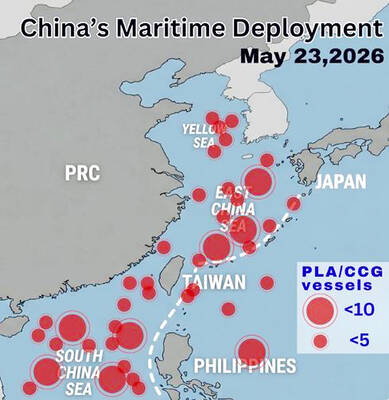
WARNING: China should stop engaging in actions that undermine regional peace and stability, as it would only build resentment among people across the Strait, the CGA said China has deployed more than 100 navy, coast guard and other vessels in waters from the Yellow Sea to the South China Sea and the western Pacific since US President Donald Trump and Chinese President Xi Jinping (習近平) met in Beijing, National Security Council Secretary-General Joseph Wu (吳釗燮) said yesterday. “In this part of the world, #China is the one & only PROBLEM wrecking the #StatusQuo & threatening regional peace & stability,” Wu wrote on X. In a separate post, he said Beijing was coercing Taiwan’s maritime domain, calling it illegal and provocative, after the Coast Guard Administration (CGA) expelled a