Despite the intense sunshine, we were hardly breaking a sweat as we cruised along the flat, dedicated bike lane, well protected from the heat by a canopy of trees. The electric assist on the bikes likely made a difference, too.
Far removed from the bustle and noise of the Taichung traffic, we admired the serene rural scenery, making our way over rivers, alongside rice paddies and through pear orchards.
Our route for the day covered two bike paths that connect in Fengyuan District (豐原) and are best done together. The Hou-Feng Bike Path (后豐鐵馬道) runs southward from Houli District (后里) while the Dongfeng Bicycle Green Way (東豐自行車綠廊) continues eastward to Dongshih District (東勢).
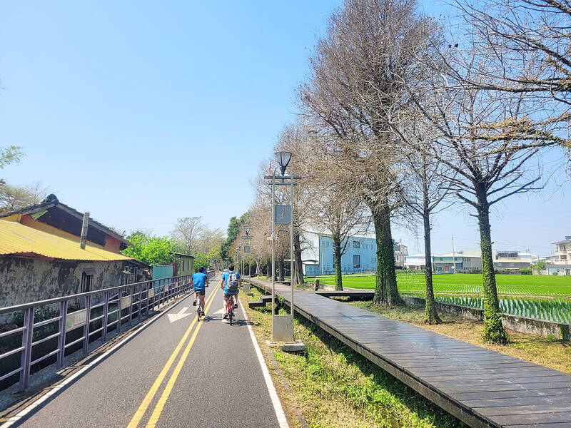
Photo: Tyler Cottenie
These highly accessible paths are a great way to enjoy the outdoors regardless of your fitness level, and the logistics are so easy to arrange that hardly any planning is required at all.
THE HOU-FENG BIKE PATH
After renting bikes from a shop outside the Houli train station, we followed the signs south and then east under the railroad tracks until we reached the start of the bike path. The route then runs right beside, and sometimes under, the current elevated railway for a while.
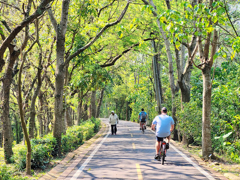
Photo: Tyler Cottenie
About 2km ahead, the Hou-Feng Bike Path enters a long tunnel. On a hot day, the sudden blast of cool air is a welcome relief. In the winter, it might even feel downright cold. With no crossing traffic to worry about, people generally ride quite fast through here, and with the walls so close on either side, there is an illusion of added speed, so this part can be quite exhilarating.
On weekends when traffic is heavier, however, stopping in the narrow tunnel to take photos would at best clog up traffic, and at worst result in a collision. This 1.2km-long tunnel was not made with bicycles in mind, but rather for trains. Built over a century ago, the Old Mountain Line No. 9 Tunnel was part of the main rail line running from Taipei to Kaohsiung. It was only abandoned in 1997 when a newer, more direct route for Mountain Line trains was opened just west of here.
The remainder of the Hou-Feng Bike Path continues to follow this old railway route to its endpoint. Nowadays, it is hard to tell there used to be a railway here as the rail bed has been replaced by beautiful asphalt that makes for smooth riding. The grade is also very gentle as the route was built for trains. It’s about as relaxing an experience as one can hope for while still getting some exercise.
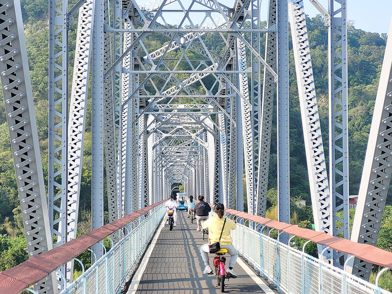
Photo: Tyler Cottenie
After leaving the tunnel, the path crosses the Dajia River (大甲溪) on a photogenic 382 meter steel bridge built in 1908. The clear blue water and white rapids contrast beautifully with the bare grey stone over which they run.
Beyond the bridge, the scenery changes again as the path passes next to rice paddies before reaching its endpoint under the No. 4 Freeway, having covered a distance of 5.8km. For those wanting to continue on the next section toward Dongshih, make a 180-degree left turn just before the freeway, at the statue of a cartoonish man standing next to a bike and giving two thumbs up.
THE DONGFENG BICYCLE GREEN WAY
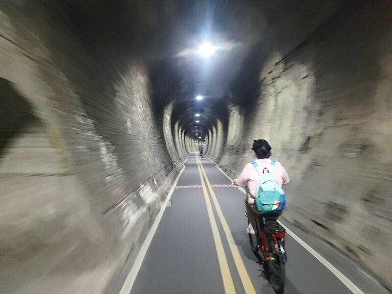
Photo: Tyler Cottenie
The reason this junction is a 180-degree turn, with the two paths running almost parallel initially, is that, once again, this junction was initially designed with trains in mind. The Dongfeng Bicycle Green Way follows the former Dongshih Line from the point where it branched off the Mountain Line. Service on the line shut down in 1991, and its conversion to a bike path taking cyclists as far as Dongshih was completed by 2000.
Having ridden from Fengyuan to Dongshih by scooter before, I was amazed at the contrast between the bike path and the road for vehicles. Whereas the latter is exposed, dusty, loud and full of traffic lights, the bike path is shady, cool, quiet, green, uninterrupted and perfused with the aroma of flowers from the orchards along the trail.
From start to finish, this path is only 13.6km, so it can be done in less than an hour. However, it’s best to plan for a few stops along the way. If you are riding on a hot sunny day, the abundant shade from the trees along the path will make the experience much more comfortable, but it you’re still feeling too hot, there are several places to stop and buy ice cream or cold drinks.
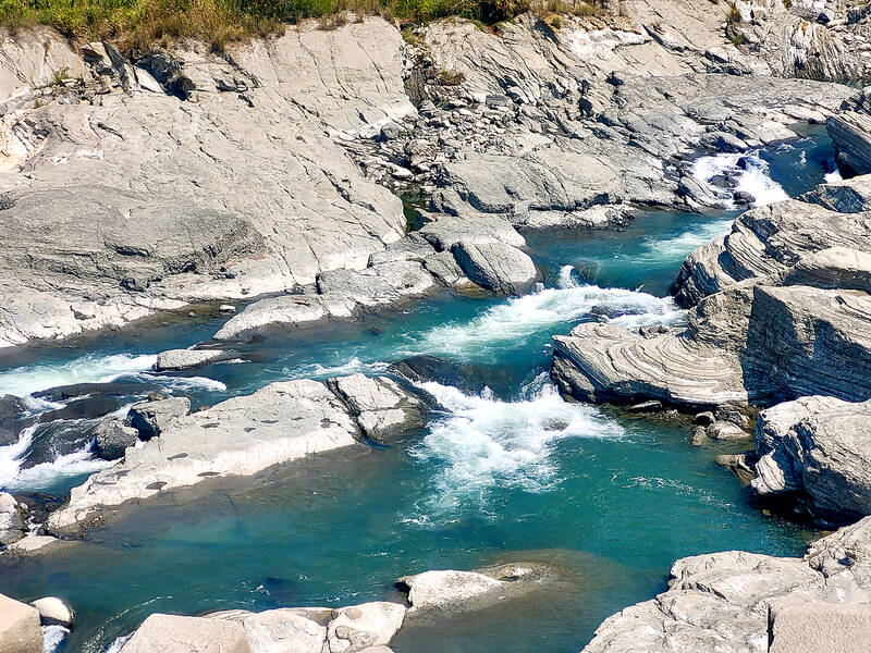
Photo: Tyler Cottenie
Damage from the 921 Earthquake is visible in at least two places along the path. Stop at the Shihgang Dam and walk across for a look at the collapsed section lying right on the fault line. Also take note of the fishway that was built in place of the old spillway to allow fish to make their way upstream around the dam.
The bike path itself crosses the fault line just a little farther ahead at the old Shihgang Station. Look for the twisted mess of rails right at the place where the earth was thrust upward. Just ahead of this, two of the original blue passenger carriages running on the old rail line have been left out as a reminder of this path’s history.
About half a kilometer before crossing the river to Dongshih, look for a sign showing toilets on the left. The toilets are at a temple just a minute off the bike path, but the main attraction here is the massive mango tree behind the temple. At over three hundred years old and 16.7 meters high, it is nothing like the trees commonly seen in southern Taiwan’s orchards. A stop here to sit in the shade of the tree or the covered plaza in front of the temple is highly recommended.
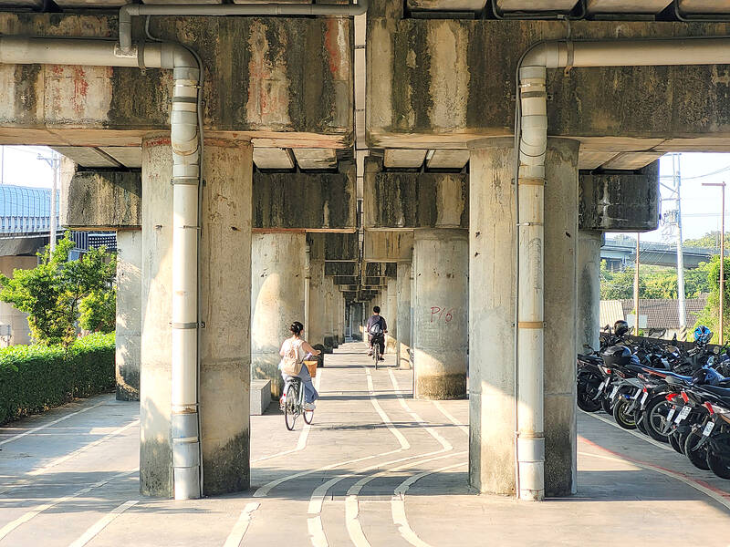
Photo: Tyler Cottenie
After crossing the Dajia River on a photogenic railway bridge for a second time, the path enters Dongshih District. The tree-lined path here is shady and fragrant as it passes through pear orchards. After passing the former Dongshih Station — now the Hakka Cultural Park — the path reaches the town center and comes to a rather abrupt end.
If this is your final destination, it’s time to return your bike and hop on a bus back to Fengyuan. If you are planning to cycle back to the start, Dongshih is a good place to stop for lunch as there are dozens of restaurant options here.
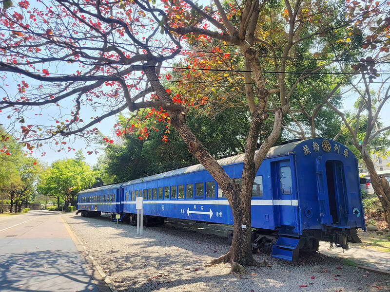
Photo: Tyler Cottenie

Taiwan’s overtaking of South Korea in GDP per capita is not a temporary anomaly, but the result of deeper structural problems in the South Korean economy says Chang Young-chul, the former CEO of Korea Asset Management Corp. Chang says that while it reflects Taiwan’s own gains, it also highlights weakening growth momentum in South Korea. As design and foundry capabilities become more important in the AI era, Seoul risks losing competitiveness if it relies too heavily on memory chips. IMF forecasts showing Taiwan widening its lead over South Korea have fueled debate in Seoul over memory chip dependence, industrial policy and

“China wants to unify with Taiwan at the lowest possible cost, and it currently believes that unification will become easier and less costly as time passes,” wrote Amanda Hsiao (蕭嫣然) and Bonnie Glaser in Foreign Affairs (“Why China Waits”) this month, describing how the People’s Republic of China (PRC) is playing the long game in its quest to seize Taiwan. This has been a favorite claim of many writers over the years, easy to argue because it is so trite. Very obviously, if the PRC isn’t attacking Taiwan, it is waiting. But for what? Hsiao and Glaser’s main point is trivial,
May 18 to May 24 Gathered on Yangtou Mountain (羊頭山) on Dec. 5, 1972, Taiwan’s hiking enthusiasts formally declared the formation of the “100 Peaks Club” (百岳俱樂部) and unveiled the final list of mountains. Famed mountaineer Lin Wen-an (林文安) led this effort for the Chinese Alpine Association (中華山岳協會). Working with other experienced climbers, he chose 100 peaks above 10,000 feet (3,048m) that featured triangulation points and varied in difficulty and character. The list sparked an alpine hiking craze, inspiring many to take up mountaineering and competing to “conquer” the summits. A common misconception is that the 100 Peaks represent Taiwan’s 100 tallest

Yesterday, the Democratic Progressive Party (DPP) nominated legislator Puma Shen (沈伯洋) as their Taipei mayoral candidate, the Chinese Nationalist Party (KMT) put their stamp of approval on Wei Ping-cheng (魏平政) as their candidate for Changhua County commissioner and former legislator Tsai Pi-ru (蔡壁如) of the Taiwan People’s Party (TPP) has begun the process to also run in Changhua, though she has not yet been formally nominated. All three news items are bizarre. The DPP has struggled with settling on a Taipei nominee. The only candidate who declared interest was Enoch Wu (吳怡農), but the party seemed determined to nominate anyone