A piece of rock with mysterious markings that lay largely unstudied for 4,000 years is now being hailed as a “treasure map” for archaeologists, who are using it to hunt for ancient sites around northwestern France.
The so-called Saint-Belec slab was claimed as Europe’s oldest map by researchers in 2021 and they have been working ever since to understand its etchings ---- both to help them date the slab, and to rediscover lost monuments.
“Using the map to try to find archaeological sites is a great approach. We never work like that,” University of Western Brittany professor Yvan Pailler said.
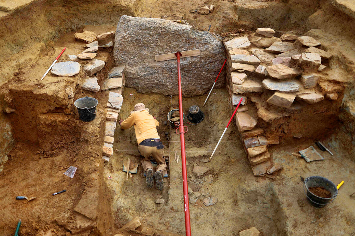
Photo: AFP
Ancient sites are more commonly uncovered by sophisticated radar equipment, aerial photography or by accident in cities when the foundations for new buildings are being dug.
“It’s a treasure map,” Pailler said. But the team are only just beginning their treasure hunt.
The ancient map marks an area roughly 30 by 21 kilometers and Pailler’s colleague, Clement Nicolas from the CNRS research institute, said they would need to survey the entire territory and cross reference the markings on the slab.
That job could take 15 years, he said.
Nicolas and Pailler were part of the team that rediscovered the slab in 2014 — it was initially uncovered in 1900 by a local historian who did not understand its significance.
The French experts were joined by colleagues from other institutions in France and overseas as they began to decode its mysteries.
“There were a few engraved symbols that made sense right away,” Pailler said. In the coarse bumps and lines of the slab, they could see the rivers and mountains of Roudouallec, part of the Brittany region about 500 kilometers west of Paris.
The researchers scanned the slab and compared it with current maps, finding a roughly 80 percent match. “We still have to identify all the geometric symbols, the legend that goes with them,” said Nicolas.
The slab is pocked with tiny hollows, which researchers believe could point to burial mounds, dwellings or geological deposits. Discovering their meaning could lead to a whole flood of new finds.
But first, the archaeologists have spent the past few weeks digging at the site where the slab was initially uncovered, which Pailler said was one of the biggest Bronze Age burial sites in Brittany.
“We are trying to better contextualize the discovery, to have a way to date the slab,” said Pailler.
Their latest dig has already turned up a handful of previously undiscovered fragments from the slab.
The pieces had apparently been broken off and used as a tomb wall in what Nicolas suggests could signify the shifting power dynamics of Bronze Age settlements.
The area covered by the map probably corresponds to an ancient kingdom, perhaps one that collapsed in revolts and rebellions.
“The engraved slab no longer made sense and was doomed by being broken up and used as building material,” Nicolas said.
If one asks Taiwanese why house prices are so high or why the nation is so built up or why certain policies cannot be carried out, one common answer is that “Taiwan is too small.” This is actually true, though not in the way people think. The National Property Administration (NPA), responsible for tracking and managing the government’s real estate assets, maintains statistics on how much land the government owns. As of the end of last year, land for official use constituted 293,655 hectares, for public use 1,732,513 hectares, for non-public use 216,972 hectares and for state enterprises 34 hectares, yielding

The small platform at Duoliang Train Station in Taitung County’s Taimali Township (太麻里) served villagers from 1992 to 2006, but was eventually shut down due to lack of use. Just 10 years later, the abandoned train station had become widely known as the most beautiful station in Taiwan, and visitors were so frequent that the village had to start restricting traffic. Nowadays, Duoliang Village (多良) is known as a bit of a tourist trap, with a mandatory, albeit modest, admission fee of NT$10 giving access to a crowded lane of vendors with a mediocre view of the ocean and the trains

The March/April volume of Foreign Affairs, long a purveyor of pro-China pablum, offered up another irksome Beijing-speak on the issues and solutions for the problems vexing the People’s Republic of China (PRC) and the US: “America and China at the Edge of Ruin: A Last Chance to Step Back From the Brink” rang the provocative title, by David M. Lampton and Wang Jisi (王緝思). If one ever wants to describe what went wrong with US-PRC relations, the career of Wang Jisi is a good place to start. Wang has extensive experience in the US and the West. He was a visiting

One of the challenges with the sheer availability of food in today’s world is that lots of us end up spending many of our waking hours eating. Whether it’s full meals, snacks or desserts, scientists have found that it’s not uncommon for us to be mindlessly grazing at some point during all of our 16 or so waking hours. The problem? As soon as this food hits the bloodstream in the form of glucose, it initiates the release of the hormone insulin. This in turn activates a switch present in every one of our cells, which is responsible for driving cell