Official maps show the roads, the power stations, the lighthouse — but skip all the special spots where generations of Indian fishermen have moored boats or dried their silvery catch, prayed for the living and buried their dead.
So now the fishermen of southern India are learning a whole new skill: mapping their ancient land by app — plot by precious plot — to stop industry from swallowing life on the lagoon.
“I am just a fisherman. I knew nothing about mapping.
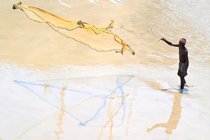
Photo: AFP
But I had to learn this so that our livelihoods are not destroyed tomorrow by the government,” said Bharath S Raji, whose family has trawled Pulicat Lake in Tamil Nadu for generations.
Smartphone in hand, Raji navigated the sandy lakeside banks to capture places of special interest — docks, drying areas for nets, shrines to local deities. He pointed out the holes left by the government’s latest coastal maps, blank spaces he said are villages brimming with life.
With a new government zoning map three months off, Raji fears his industry and whole way of life will become the next black hole of Lake Pulicat.
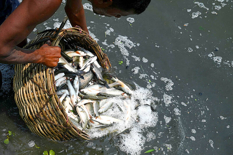
Photo: AFP
“We always owned the land. But the government keeps changing the rules not realizing that our customs and our livelihood here is older than their rules,” said Raji, a 33-year-old father of two.
Raji and his fellow fishermen of Gunankuppam have captured the co-ordinates of hundreds of special places on Google Maps and other apps, none of them designated as landmarks in official government maps.
Industrial proposals to develop the creek around Gunankuppam label the places the fishermen most cherish as “wastelands,” Raji said, fearing the rapid industrialization that is transforming much of India is about to slap him in the face.
Proposals for the creek include a port and power plant, developments that could beach the flotilla of hundreds of gaily painted boats that trawl the lagoon for mackerel and sea bass.
OLD VS NEW
“The maps released by the Tamil Nadu coastal zone management authority have agitated the fishermen community as they are not detailed,” said Ajay Anand, assistant director of fisheries in Thiruvallur district, a key member in the government agency that will determine the fate of the lake.
“So, the fishermen community took it upon themselves to do the survey.”
“There have been many attempts of industrial encroachment but the local fisherfolk used the maps as a guide to fight them,” he said.
The fishermen’s maps will be independently cross-checked by the fishing department, Anand said.
“Eventually, the government will use the maps prepared by us,” he said.
India’s ministry of environment, which oversees coastal zoning, did not respond to a request for comment.
The fishing villages around the Ennore peninsula, where the village of Gunankuppam and lake are located, slip between India old and new.
Around the creek, wooden boats and loinclothed fishermen wade through sludgy waters surrounded by foundries, thermal power plants and ship yards.
The dissonance between timeless life on the lagoon and naked ambition for a high-tech future is underscored by a rumbling speck on the horizon — India’s national space station — visible from the lake.
Locals have seen India launch satellites, even as they struggle to feed families from their rich waters and fertile soil.
“I don’t feel any pride about the country,” said fisherman Magimairaj D, whose earnings total 20,000 rupees (US$243.25) a month. “You think India is developing? Not at all.”
MAPPING DRIVE
“Fishermen lose their lives and livelihoods in the process of this development,” said Saravanan K, a coordinator at the Coastal Resource Centre, a local environmental activist group.
“Our lands are being used to generate electricity. But we are deprived. The sea, the river — which were sources of our livelihood — are polluted in the process,” Saravanan said.
Saravanan opened his laptop and pulled up the GIS software he uses to map hundreds of villages in his area, cross-checking the sites designated by fishermen such as Raji against satellite images of the entire area.
Saravanan said he learned how to use the software from a friend who had studied software engineering and from YouTube.
Next he recruited statewide volunteers to map the land.
“The technology is the same [as what the government uses] ... it’s just that they don’t do it and we do,” he said.
Given that mobile phones only came to Gunankuppam in 2006, the rapid takeup of mapping apps seems all the more striking.
Raji was among the first three villagers to own a Nokia phone, and would travel 20 km by road to pick up a signal.
Access to cheap smartphones has since skyrocketed, even in the hinterlands, with a billion smartphone users predicted across India by 2026, according to a Deloitte report last year.
And the fishermen look at past successes to motivate future mapping missions.
They cite appeals lodged with the National Green Tribunal, a government body that enforces environmental protections, that have curbed industrial activities in protected coastal areas.
Their efforts helped block a thermal power station from expanding into ancient fishing zones, and stymied a private takeover of public waters, Saravanan said.
Durai Mahendran, state president of the Tamil Nadu fisherman association, credited local mapping efforts with saving his village from a development drive that is reshaping swathes of the fragile coast.
Watching the sun set over Pulicat lake, fisherman Dayalan D is a convert to new technology to preserve his old way of life.
“Whenever the government comes up with a proposal to construct a road or any structure, it is easy for them to encroach on our land,” said the 39-year-old fisherman.
“But with the right documentation in the form of maps, we can prove our claims on the land.”
Ajay Verma, a consultant gastroenterologist at Kettering general hospital in Northamptonshire, says our gut is a “complex machine.” “It is constantly providing us with the nutrition we need, initially to grow and develop, and then for us to survive, thrive and repair from injury and illness.” How can we keep it functioning well? Put simply: “Make sure what you put into it is balanced, and that you clear out its waste products adequately,” Verma says. “In a general gastroenterology clinic, the most common conditions we see are irritable bowel syndrome (IBS), gastroesophageal reflux disease, inflammatory bowel disease and constipation,” says Nisha

And so, in the wake of US President Donald Trump’s trip to the People’s Republic of China (PRC), all the experts on the Strait of Hormuz suddenly became experts on US-China-Taiwan relations. The Internet has certainly expanded human knowledge. Lots of these sudden experts made noise this week about Trump’s words after the meeting with PRC dictator Xi Jin-ping (習近平). Trump is going to sell out Taiwan! Longtime Taiwan commentator J. Michael Cole summed the situation up neatly in the Guardian: “We need to keep in mind that he has a tendency to say many things — sometimes contradicting himself within

Last week US President Donald Trump was asked by a reporter whether he would speak on the phone to the President of Taiwan. “l’ll speak to him. I speak to everybody. We have that situation very well in hand,” Trump said. This marked the second time in a couple of weeks he had said he would talk to the President of Taiwan. In 2016 he famously took a call from then-president Tsai Ing-wen (蔡英文), when he was president-elect. Despite warnings that the apocalypse was nigh because of a phone call, the world quickly forgot about the conversation between two democratically-elected presidents.
May 25 to May 31 Few believed that apples could be cultivated on a commercial scale in Taiwan’s high mountains. When horticulturalist Cheng Chao-hsiung (程兆熊) first proposed the idea in 1955, both American and Taiwanese colleagues dismissed it as implausible, arguing that temperate fruit could not be reliably grown on a subtropical island, especially on rugged terrain. However, it was this terrain in the Central Mountain Range where many Chinese Civil War veterans were resettled in the late 1950s. With limited job prospects and no family in Taiwan, they were placed on cooperative farms aimed toward self-sufficiency. Some say the conditions