Rising straight out of the Pacific, Cingshuei Mountain (清水山) offers determined hikers a view of the ocean unlike almost anywhere else on the planet: over two kilometers up and nearly straight overhead. Reaching this peak requires a three-day commitment, but there is plenty to see along the way.
The trail to Cingshuei Mountain passes through old logging lands, as well as the Truku Aboriginal communities of Xoxos (Dali Village, 大禮) and Skadang (Datong Village, 大同), where there are comfortable guesthouses. Finally, exit the mountain with a walk along one of the most scenic places in Taroko Gorge, the Shakadang Trail (砂卡噹步道).
The hike begins near sea level behind the Taroko National Park Visitor Center, on the Dekalun Trail (得卡倫步道), which is essentially a very long staircase. At the end of this trail, the climbing continues on a forest trail until flatter ground is finally reached some 800 meters above sea level. From here, it is a much easier walk along the Shakadang Forest Road all the way to Skadang Village.
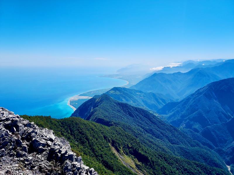
Photo: Tyler Cottenie
This forest road was built for logging purposes but does not actually connect to the rest of Taiwan’s road network. In the past, timber was hauled down this road to a cableway station and then sent the rest of the way down the gorge by cable. Nowadays, the cableway is still maintained and is used to bring supplies up for the two mountain villages. The road itself is still passable to vehicle traffic between the cableway station and Skadang, and locals regularly drive motorcycles and motorized farm wagons back and forth moving supplies.
TRUKU VILLAGES
Further up the road, a small trail off to the left leads to Xoxos, a quick side trip from the main road. Some farming activity continues to this day at Xoxos, and there is an operational guesthouse, built in the modern corrugated-steel style.
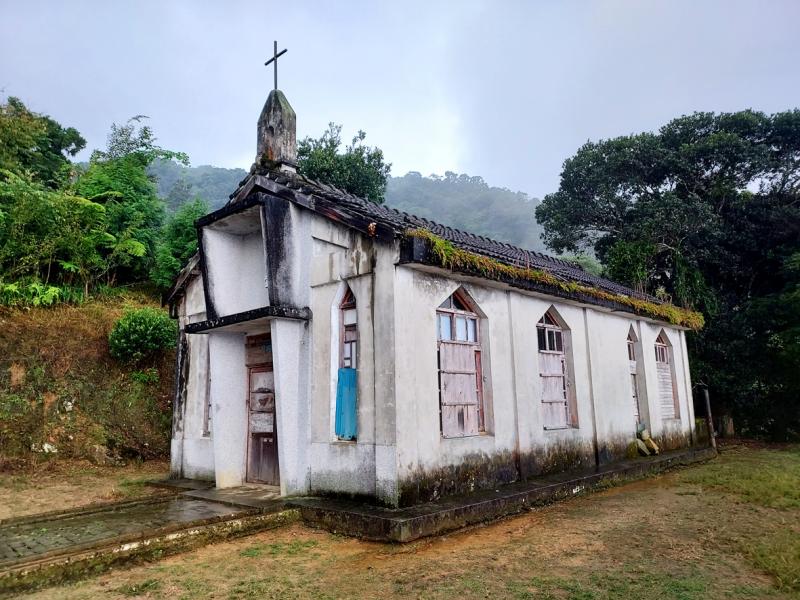
Photo: Tyler Cottenie
The concrete shell of the former school and a mostly-intact church also stand here, remnants of a once-bustling village whose residents were relocated down into the gorge in 1979. The easiest way to Skadang Village from here is to double back to the paved forest road and continue north. Alternatively, there is a trail from Xoxos that meets up with the forest road again near Skadang.
Though the people of Skadang were also relocated in 1979, farming activity continues here and the guesthouse business has seen a boom in recent years. There are several options available, but we stayed at the Rainbow House (太魯閣大同大禮部落之彩虹屋), run by Piyut Nowbu (簡明熙) and his family (search for tarokorainbowhouse on Facebook).
We arrived at dinner time to a lively atmosphere: the porch was packed with guests enjoying their dinner as the owner’s brother, Watan (簡明賢), serenaded everyone with Truku songs. Guesthouses up here are not connected to the power grid and so rely on a generator and batteries for lighting (as well as the microphone and speaker). Despite this limitation, the guesthouse is still full of creature comforts not usually found on overnight hiking trips in Taiwan: lights, clean drinking water, covered seating areas, quilts, pillows and toilets.
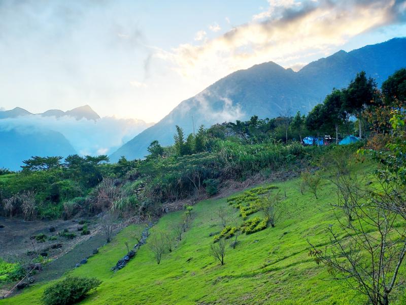
Photo: Tyler Cottenie
The Nowbu family also has wood-burning stoves with water boilers on top, and all guests are entitled to one generous bucket of hot water with which to bathe at the end of the day. Their supplies are all hauled up the mountain by cable car when the operator is available, or by porter otherwise.
CINGSHUEI MOUNTAIN
The second day of this trip was the main event: the return hike to Cingshuei Mountain. For fit hikers, this is at least a 12-hour journey; for many, it takes even longer. This means that the hike usually starts in the dark, and sometimes even ends in the dark.
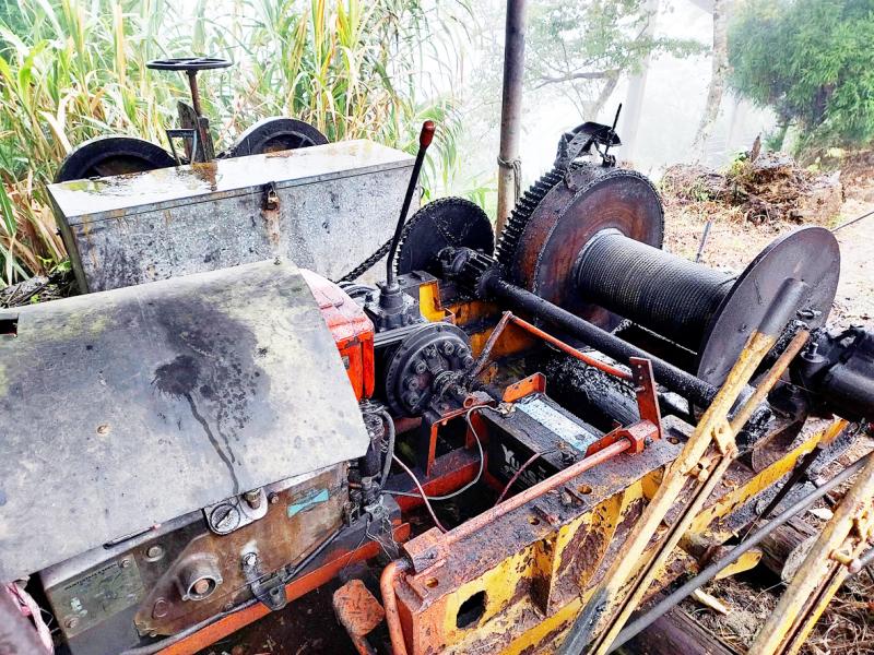
Photo: Tyler Cottenie
We headed out at first light, continuing along the Shakadang Forest Road. As this section is no longer used by vehicles, it has been quickly reclaimed by vegetation and landslides. The grade is nearly flat, but tangles of ferns and sketchy makeshift log bridges hinder progress. Where the forest road ends at another former cableway site, the hiking trail branches off to the right, marking the start of a 900-meter ascent directly to the peak.
The steepness alone makes this exhausting; in poor weather, the slippery rocks and roots would make this hike treacherous and unadvisable. Luckily, the weather was dry and sunny and we were rewarded for our efforts with spectacular views that got better and better as we neared the top. The final approach includes an exposed knife-edge ridge of Taroko marble with the Central Mountain Range visible behind and the turquoise waters of Hualien’s coastline off to the side.
Few places on Earth offer views of the ocean that are so high up but also so close. Those who have seen the Cingshuei cliffs along the Suhua Highway will have some idea of how quickly the mountains drop into the sea here. In fact, Cingshuei Mountain rises 2,408 meters from sea level less than four kilometers away from the coast, an even more dramatic rise than the volcanoes of Hawaii.
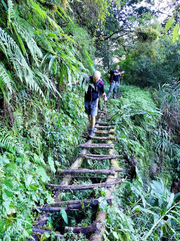
Photo: Tyler Cottenie
From the peak, the westernmost Japanese island of Yonaguni is visible on very clear days. Unfortunately, we could not find it in the haze on this day, even with binoculars.
After a quick lunch break and a descent full of tricky footwork, we made it back to the Rainbow House at dusk. A hot bath and hearty meal quickly restored some of our vigor and, as this was a Sunday night, most of the other guests had left, so we were able to appreciate the tranquility of the mountain setting.
Weekends have become very busy here for the Nowbu family and they have expanded the size and capacity of their guesthouse to meet demand. In the past, their home here was made in the traditional Truku style with bamboo. However, the bamboo in this type of house is inevitably weakened by termites and has to be entirely replaced every 10 years, so the family eventually opted to replace the dwelling with a more long-lasting, though perhaps aesthetically inferior, corrugated steel structure.
The family still speak Truku with each other and live on their ancestral lands, but they have adapted a modern approach to their business.
Instead of retracing our steps from the first day on our last day, we completed a full loop by taking a forest trail down to the end of the Shakadang Trail, then following this trail out to Highway 8 and returning to the Visitor Center.
The Shakadang Trail is a popular day hike for visitors to Taroko Gorge and makes for the perfect ending to a Cingshuei Mountain itinerary. This wide flat path, originally built by the Japanese as part of a hydroelectric project, hugs the banks of the Shakadang River and is hewn out of solid marble in places. It passes a dam, an enormous overhead water diversion pipe and a number of clear green river pools surrounded by Taroko marble with swirling dark lines. After this relaxing stroll, a left turn at the highway and a walk through the tunnel brought us back to the Visitor Center where our journey began.
Taiwan’s renewable shortfall is a problem of execution, not resources. Japan’s long-cycle, joined-up energy planning is the model worth studying — but what Taiwan can borrow is the institutional machinery, not the politics. When Nvidia CEO Jensen Huang (黃仁勳) used his visit to Taipei last month to warn that the country needs far more electricity, he was naming a constraint its own planners already know well: Taiwan Power Co (Taipower, 台電) expects demand from the semiconductor and artificial intelligence (AI) sector alone to exceed 5 gigawatts (GW) by 2030. The harder question is not whether to build more capacity but which
In a projection room, visitors at the Re: Battle City exhibition at Kaohsiung’s Neiwei Arts Center are invited to sit and watch a 20-minute animated movie. Artist Chang Li-ren (張立人) created the movie with dolls he made by molding paper into crude, painted figurines. The dolls interact in a detailed and realistic Taiwanese cityscape. Outside the projection room, visitors can wander around a massive model of the city. A sizeable crowd happily takes pictures of what looks like the best dollhouse in Taiwan: the same props that were used to tell the story of the country’s descent into techno-dictatorship in the movie. The

The last time Taiwan’s foreign correspondents were invited to a special briefing with a sitting president was in 2015. That was two presidents ago under Ma Ying-jeou (馬英九). But Thursday morning, President William Lai (賴清德) welcomed the nation’s international press corps warmly, speaking specifically to the theme of press freedom. Lai addressed Taiwan’s foreign press corps saying, “You live, work and report in Taiwan.” “Thank you for your professionalism and upholding the spirit of press freedom,” he continued. “As you engage in your work of journalism, you let the world see Taiwan.” The timing of this event, hosted by the Taiwan Foreign

Chinese Nationalist Party (KMT) Chairwoman Cheng Li-wun’s (鄭麗文) recent trip to the US highlighted her party’s anti-Taiwan defense policies. Disapproval of their policies was strong among those who met with her. Republican Senator Dan Sullivan, said that the KMT was “playing with fire.” Democratic Representative Tom Suozzi reportedly said that Cheng’s party was “weakening deterrence.” Foreign policy maven David Sacks observed in Asia Nikkei that “many Americans struggle to see the logic behind the KMT’s refusal to fund the portion of the special defense budget pertaining to indigenous defense production.” The logic of the KMT’s decision to purchase only US