The 27km walk along the A-Si Trail (阿溪縱走) is at once a journey through man’s attempt to tame and harvest the wilderness, as well as a powerful reminder of the forces of nature. Hikers walk on railway lines, forestry roads and small footpaths, passing tunnels, bridges and buildings, now regretfully abandoned after considerable earthquake and typhoon damage.
Even the land itself has been irrevocably changed by these natural disasters, with one section of river and its surrounding forest drowned by an earthquake. Yet there is one symbol of resilience: a giant cypress that has stood watch here for over 4,000 years, seemingly immune to the havoc and destruction surrounding it.
THE ALISHAN RAILWAY
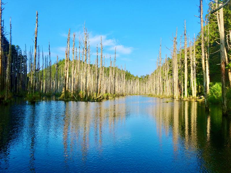
Photo: Tyler Cottenie
Decades ago, the A-Si Trail was usually done in reverse, with hikers setting out from Nantou County’s Sitou area (溪頭) and walking up to Chiayi County’s Alishan Forest Railway’s most remote station, Shihhou (石猴). From there, hikers would proceed along the Mianyue Branch Line (眠月支線) into the Alishan Forest Recreation Area (阿里山國家森林遊樂區). At its opening a century ago, this was a logging line, but it later carried tourists in an old-fashioned steam locomotive.
In 1999, however, the 921 Earthquake damaged the branch line and hikers mostly abandoned this route. Despite a brief reopening after costly repairs, Typhoon Morakot sounded the final death knell for this line in 2009. A landslide sliced through one of the railway tunnels and is now one of the more thrilling — or terrifying, depending on the hiker — obstacles that must be overcome.
Nowadays, hikers usually begin in Alishan on foot. After half an hour walking on the Mianyue Line, the tunnel sliced open by Morakot is reached. Halfway through the tunnel, there is a chaotic jumble of chunks of concrete and twisted rebar, and then hikers are suddenly out in the open, with a wall of solid rock to one side and the remaining section of tunnel far ahead across a gaping chasm. Fortunately, sturdy hand and foot holds have been improvised from rebar and track remnants and the chasm can be crossed relatively safely.
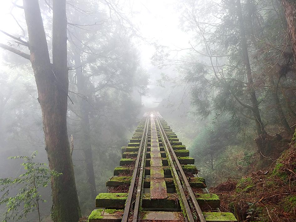
Photo: Tyler Cottenie
After rejoining the railroad on the other side, the trail continues toward Shihhou Station. Since this is a rail line, the grade is nearly flat and the walking is easy. However, since this is a rail line, the bridges (of which there are 24) were not intended for pedestrian traffic and have neither railings nor a sturdy floor for walking. Each step must be made carefully along the narrow wooden plank between the rails or on the beams, while trying not to be dizzied by the view of the ground far below. Often the air at this elevation (2,300m) is saturated with fog and the longer bridges appear to disappear into the sky ahead. In one of the tunnels (of which there are 14), hikers have to climb up and over the rubble from a collapsed ceiling section in the dark, so be sure to bring a flashlight.
After three to four hours of walking through gorgeous coniferous forest and a nature reserve for an endemic orchid, the Taiwan Pleione, hikers pass by a trickling fresh water source and arrive at the line’s final passenger station, Shihhou Station. Its name refers to a stone outcropping in the mountain nearby that used to resemble a monkey, before it was decapitated by the 921 Earthquake. The slanting wooden shell of the station building remains and the level concrete floor under the protection of the roof is regarded as a prime campsite by hikers and snatched up early. Some make a day trip of the Mianyue Line and return to Alishan immediately, but A-Si hikers usually sleep here.
Beyond Shihhou the railroad continues, but this section only saw logging operations, never passenger service. In places, rails are suspended in midair like the cables of a suspension bridge with no deck, spanning areas where the railroad bed has been washed out by landslides. Soon, the A-Si Trail leaves the Alishan Railway behind, becoming a simple narrow footpath climbing steeply through the forest.
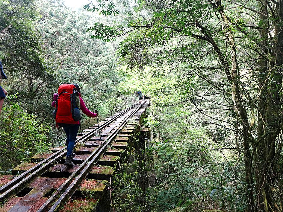
Photo: Tyler Cottenie
TREES, LARGE AND DROWNED
Peak baggers will enjoy the next part as the path climbs up to a 2,557-meter peak, Songshan (松山), and the forest opens up to a view of Jade Mountain. This is followed by a long and sometimes slippery descent. Partway down, the trail levels out momentarily as it crosses the bed of a long-forgotten Japanese logging railway line, tracks still in place. It is a reminder of the incredible lengths (literally and figuratively) to which the Japanese administration went in order to harvest Taiwan’s timber.
Near the bottom of the descent, there is a side trail to the Mianyue Sacred Tree. According to local legend, the name of this tree, and the railway line from the previous day’s walk, comes from a Japanese forest surveyor. One night, while under the shelter of a large primordial forest of cypress trees, the moon rose over the mountains and cast a beautiful light through the canopy. He was so moved by this moment that the image remained imprinted in his mind for years. When he returned to the area over a decade later, he was saddened by the loss of trees to logging operations and decided to call the area “Sleeping Moon” (Mianyue) in honor of the beautiful place it once was.
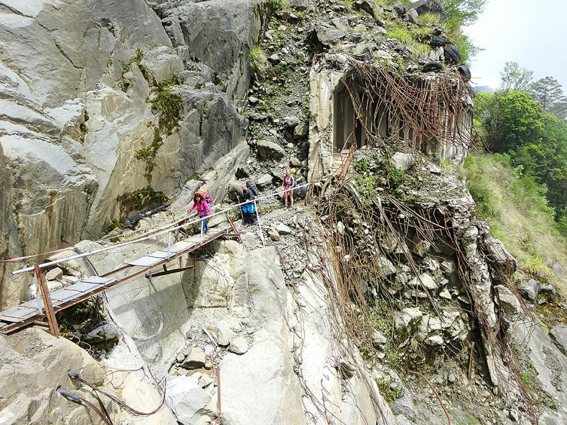
Photo: Tyler Cottenie
The Mianyue Sacred Tree is one such cypress tree; it is also the third largest tree in Taiwan and one of the oldest, at over 4,000 years. Unlike many others, this one presumably has a lightning rod high up, as there is a grounding wire running down its trunk. The lush, tranquil surroundings and visual symmetry of the tree make this a worthwhile side trip.
Finally, the trail arrives down at Shuiyang Forest (水漾森林), one of Taiwan’s newest lakes. After the 921 Earthquake triggered a landslide that blocked the river here, a barrier lake formed behind the slide, drowning a large number of trees in the process. The trees have died, lost their needles and been bleached by the sun, but are still erect. This eerie tree graveyard creates beautiful white reflections against the blue surface of the water and will have any landscape photographers who visit busy for hours.
A-Si hikers usually spend the final night here. Be warned, it can be rather busy, as many people do out-and-back overnight trips here from Shanlinsi (杉林溪), the A-Si’s endpoint. The way out the following day involves a climb out of the valley and a long walk out on an old forest road left over from more recent logging operations. Hikers eventually reach a paved road at Shanlinsi, marking the end of the current A-Si Trail. From here, a tourist shuttle takes you into the main hub for the recreation area where further bus connections are available.
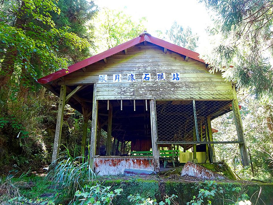
Photo: Tyler Cottenie
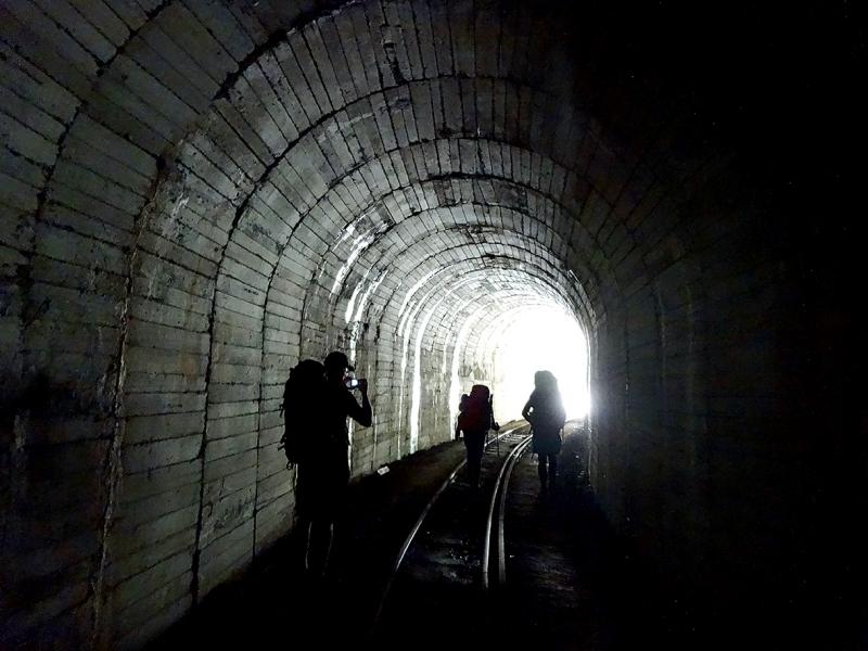
Photo: Tyler Cottenie

Photo courtesy of Wikimedia Commons

Taiwan’s overtaking of South Korea in GDP per capita is not a temporary anomaly, but the result of deeper structural problems in the South Korean economy says Chang Young-chul, the former CEO of Korea Asset Management Corp. Chang says that while it reflects Taiwan’s own gains, it also highlights weakening growth momentum in South Korea. As design and foundry capabilities become more important in the AI era, Seoul risks losing competitiveness if it relies too heavily on memory chips. IMF forecasts showing Taiwan widening its lead over South Korea have fueled debate in Seoul over memory chip dependence, industrial policy and

“China wants to unify with Taiwan at the lowest possible cost, and it currently believes that unification will become easier and less costly as time passes,” wrote Amanda Hsiao (蕭嫣然) and Bonnie Glaser in Foreign Affairs (“Why China Waits”) this month, describing how the People’s Republic of China (PRC) is playing the long game in its quest to seize Taiwan. This has been a favorite claim of many writers over the years, easy to argue because it is so trite. Very obviously, if the PRC isn’t attacking Taiwan, it is waiting. But for what? Hsiao and Glaser’s main point is trivial,
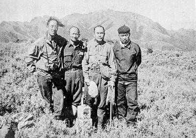
May 18 to May 24 Gathered on Yangtou Mountain (羊頭山) on Dec. 5, 1972, Taiwan’s hiking enthusiasts formally declared the formation of the “100 Peaks Club” (百岳俱樂部) and unveiled the final list of mountains. Famed mountaineer Lin Wen-an (林文安) led this effort for the Chinese Alpine Association (中華山岳協會). Working with other experienced climbers, he chose 100 peaks above 10,000 feet (3,048m) that featured triangulation points and varied in difficulty and character. The list sparked an alpine hiking craze, inspiring many to take up mountaineering and competing to “conquer” the summits. A common misconception is that the 100 Peaks represent Taiwan’s 100 tallest

In a sudden move last week, opposition lawmakers of the Chinese Nationalist Party (KMT) and Taiwan People’s Party (TPP) passed a NT$780 billion special defense budget as a preemptive measure to stop either Chinese leader Xi Jinping (習近平) or US President Donald Trump from blocking US arms sales to Taiwan at their summit in Beijing, said KMT heavyweight Jaw Shaw-kong (趙少康), speaking to the Taipei Foreign Correspondents Club on Wednesday night in Taipei. The 76-year-old Jaw, a political talk show host who ran as the KMT’s vice presidential candidate in 2024, says that he personally brokered the deal to resolve