Over a million years in the making, the outdoor playground that is Kaohsiung’s Shoushan (壽山), commonly known as “Monkey Mountain,” is a rich geological and ecological resource that visitors to the city should be sure not to miss. Many are familiar with the area’s hiking trails and resident monkey population, but even locals may be surprised to learn of the extensive system of caves here, full of classic examples of speleothems like stalactites, stalagmites, draperies and flowstones, as well as cave-dwelling fauna.
These caves are the result of hundreds of thousands of years of erosion slowly dissolving the mountain’s limestone. There are hundreds of such cavities, some extending dozens of meters into the mountain. To this day, no complete survey has ever been done. The stone itself was laid down by corals in nascent Taiwan’s shallow coastal waters over a million years ago, before being driven upwards by tectonic action. Indeed, marine fossils are common all over the mountain.
NATIONAL PARK
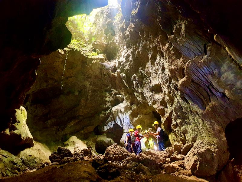
Photo: Tyler Cottenie
In 2011, Monkey Mountain, along with a few other nearby hills, became protected as Shoushan National Nature Park. With the establishment of the Park, the “Wild West” days of Monkey Mountain came to an end, and the vast system of limestone caves on the mountain, formerly a spelunking free-for-all, became mostly off limits.
Currently, public access is officially limited to four caves, only between the months of November and April, and only when accompanied by a park-certified guide (details below). The other hundred-odd caves are not gated in any way to prevent access, but according to the law such access is now forbidden. Our group was led through all four caves last month by cave guide Chin Nan.
WALKING UNDERGROUND
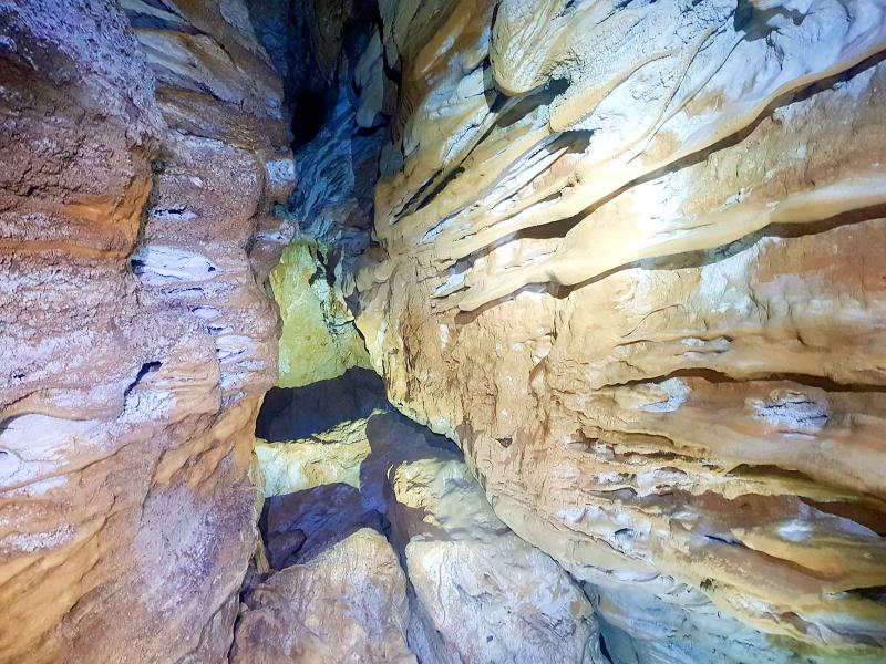
Photo: Tyler Cottenie
Our first stop was Orangutan Cave (猩猩洞), named after several ape-shaped rocks found inside. The high ceiling and flat floor make this the safest and easiest of the four caves to explore. For those who are looking for more of a challenge — and are of slim build — there is, however, a narrow passageway that one can attempt to squeeze through.
At our guide’s encouragement, I attempted this, and without his further encouragement toward the end, I would not have gotten through. I started crawling along the floor under a ceiling that got progressively lower, until the only way forward was by sliding on my back, inching forward as the weight of tons of limestone hung just above my nose. At last I reached a wall and a narrow vertical space in which I could stand up.
Passing through this space and back out to the main cave chamber just a meter or two away still took several minutes. The space was so narrow that I had to pass my helmet out to the guide first so that my head could fit. The subsequent contortions required to step up, over and out made me regret not taking yoga classes in preparation for this trip. I wouldn’t have even believed it possible were it not for the guide’s insistence that others had made it through. Only one other person in the group attempted the passage but he was not successful. The rest of the group thoroughly enjoyed the experience of watching our attempts — the entertainment value of watching a friend struggling to squeeze through a narrow gap cannot be overstated.
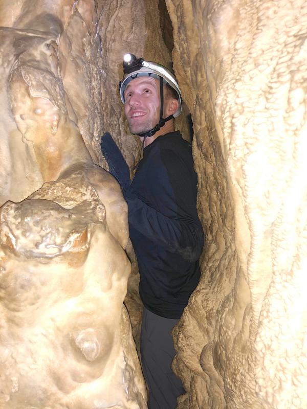
Photo courtesy of Brett Gentle
Next on the agenda was Tianyutiancai Cave (天雨天財洞), literally “Sky Rain Sky Fortune Cave.” It is the most visited and photographed cave on the mountain and derives its name from the hole in the ceiling near the entrance that allows rain to fall into the cave (Sky Rain) and the hole in the ceiling at the far end of the cave, whose shape resembles either an old Chinese cash coin or a sycee (Sky Fortune).
The latter location attracts the Instagram crowd, as sunlight streaming through this hole under just the right conditions creates a sort of heavenly light illuminating those standing below. If conditions aren’t just right for this photo, this cave still has plenty to offer. We found the molted exoskeleton of a Macrothele spider and a collection of snail shells, some of which were so old they were already being incorporated into the limestone on the cave floor. In addition, the beautiful flowstone on the walls here can be seen all at once thanks to the natural lighting provided by the “Sky Fortune” hole.
CRAWLING AND CLIMBING

Photo: Tyler Cottenie
After a lunch break, we continued on to the third cave of the day, Beifong Jile Cave (北峰極樂洞), literally “North Peak Bliss Cave.” This was the highlight of the day for most of us, as our guide set up ropes, allowing us to enter the cave by rappelling down a vertical wall and to exit the cave on the other end with a belayed rope climb.
Fortunately, Chin Nan is a rock-climbing instructor by profession and was able to set this up for us; not every caving guide has this expertise. The interior of this cave was arguably the most impressive as well, with quartz deposits glittering like a thousand diamonds, massive limestone draperies protruding from the walls under a ceiling at least fifteen meters high and cave crickets on the rocks below silently observing the passage of yet another group of curious humans. This is the underground cathedral that comes to mind when one thinks of caving.
On our way to the last cave, we passed a group of locals out climbing on a perfect vertical face of limestone. The location looked ideal for the sport, but as it was not the park-designated climbing wall, they were risking a NT$3,000 fine.

Photo courtesy of Brett Gentle
Rock climbing on Monkey Mountain, as with caving, is officially limited to designated sites only. Near this climbing wall, our guide took us along an exciting footpath (permit not required) called the Little Zhuilu, named after the Zhuilu Trail (錐麓古道) in Hualien’s Taroko National Park. Like its namesake, this path is a narrow walkable strip perched halfway up a cliff, and like its namesake, it is not for acrophobes, though there are some ropes in place for safety.
After Little Zhuilu, we arrived at the entrance to the final cave of the day, Jingua Cave (金瓜洞), literally “Pumpkin Cave,” named after a giant symmetrical flowstone inside which looks remarkably like an inverted pumpkin. The highlight of this cave turned out not to be its namesake stone, but the animal life we encountered. There was another cave cricket, a huntsman spider and a solitary bat hanging from the ceiling who was not at all camera shy. The exit from this cave is a narrow hole just wide enough for one person to crawl up and out: a fitting end to a day of walking, rappelling, climbing and crawling our way through the limestone underbelly of Monkey Mountain.
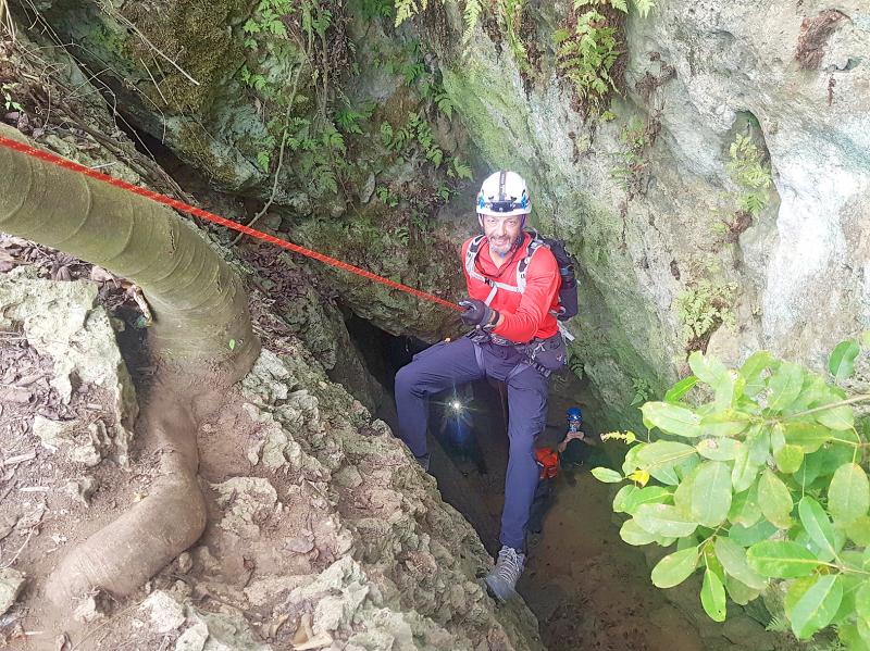
Photo: Tyler Cottenie
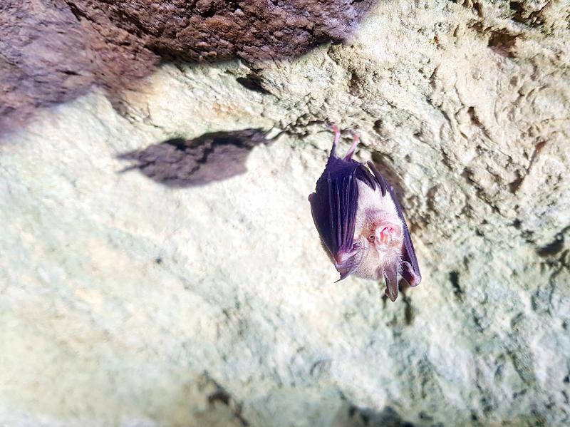
Photo: Tyler Cottenie
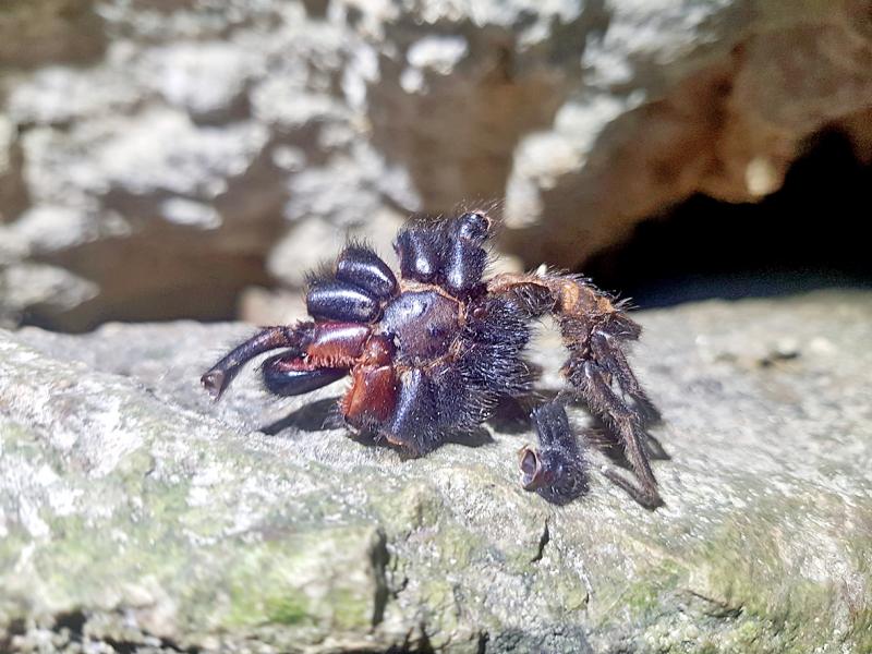
Photo: Tyler Cottenie

Photo: Tyler Cottenie
If one asks Taiwanese why house prices are so high or why the nation is so built up or why certain policies cannot be carried out, one common answer is that “Taiwan is too small.” This is actually true, though not in the way people think. The National Property Administration (NPA), responsible for tracking and managing the government’s real estate assets, maintains statistics on how much land the government owns. As of the end of last year, land for official use constituted 293,655 hectares, for public use 1,732,513 hectares, for non-public use 216,972 hectares and for state enterprises 34 hectares, yielding

The small platform at Duoliang Train Station in Taitung County’s Taimali Township (太麻里) served villagers from 1992 to 2006, but was eventually shut down due to lack of use. Just 10 years later, the abandoned train station had become widely known as the most beautiful station in Taiwan, and visitors were so frequent that the village had to start restricting traffic. Nowadays, Duoliang Village (多良) is known as a bit of a tourist trap, with a mandatory, albeit modest, admission fee of NT$10 giving access to a crowded lane of vendors with a mediocre view of the ocean and the trains
Traditionally, indigenous people in Taiwan’s mountains practice swidden cultivation, or “slash and burn” agriculture, a practice common in human history. According to a 2016 research article in the International Journal of Environmental Sustainability, among the Atayal people, this began with a search for suitable forested slopeland. The trees are burnt for fertilizer and the land cleared of stones. The stones and wood are then piled up to make fences, while both dead and standing trees are retained on the plot. The fences are used to grow climbing crops like squash and beans. The plot itself supports farming for three years.

For many people, Bilingual Nation 2030 begins and ends in the classroom. Since the policy was launched in 2018, the debate has centered on students, teachers and the pressure placed on schools. Yet the policy was never solely about English education. The government’s official plan also calls for bilingualization in Taiwan’s government services, laws and regulations, and living environment. The goal is to make Taiwan more inclusive and accessible to international enterprises and talent and better prepared for global economic and trade conditions. After eight years, that grand vision is due for a pulse check. RULES THAT CAN BE READ For Harper Chen (陳虹宇), an adviser