For most residents of Taiwan, the word “Kenting” conjures up images of white sandy beaches, turquoise waters, jet skis and maybe a crowded night market. Among all the commotion, it’s easy to forget that Kenting is in fact a national park, with a mission to protect the natural environment. For those looking to escape the crowds, learn more about southern Taiwan’s ecology, or simply add some variety to a beach holiday, the Ecological Protection Areas of Kenting National Park are an excellent addition to any trip.
The four Ecological Protection Areas open to the public are all located on the less developed eastern side of the park. Three of them — Sizihkou (溪仔口), Longkeng (龍坑) and Bitou Grassland (鼻頭草原) — sit next to the Pacific Ocean, while Nanren Mountain (南仁山) sits further inland.
All operate with a maximum daily visitor quota and can only be accessed by prior application and payment. Tourists are accompanied by a park guide (Mandarin only), who are highly knowledgeable and are often locals with an intimate understanding of not only the animal and plant life in the area, but also the history of its human inhabitants, allowing them to interweave stories of the local people’s use of the land with an introduction to the ecology of the protected area.
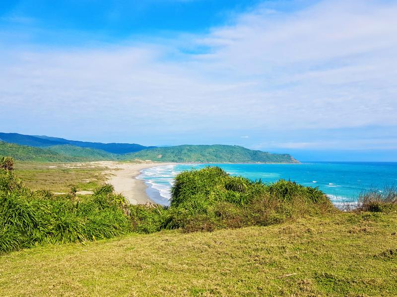
Photo: Tyler Cottenie
LONGKENG: WONDERFUL WINDSWEPT CORAL
Located just around the corner from the Oluanpi Lighthouse (鵝鑾鼻燈塔) and the southernmost point of Taiwan proper, Longkeng takes visitors on a three-kilometer walk through secondary forest out to a windswept coral landscape and back again.
Our guide pointed out subtle signs of changes to the vegetation likely due to the low rainfall Taiwan experienced last year. More obvious was the devastation further down the trail caused by a recent fire in the area. Screw pine trunks stand leafless and charred as they begin their slow recovery from the blaze, started by a discarded cigarette butt from a careless tourist.
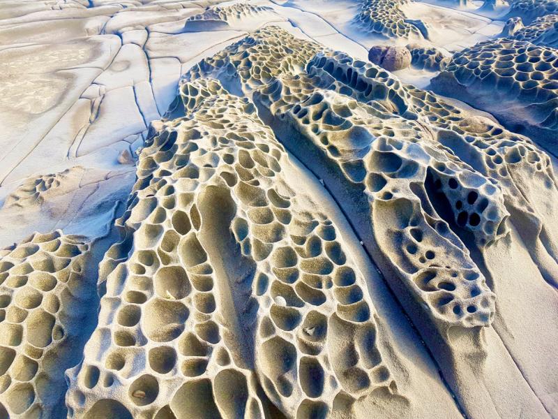
Photo: Tyler Cottenie
Near the coast, the vegetation is no match for the constant onslaught of wind and salty spray from the ocean, resulting in a barren landscape of dark coral rock eroded into myriad shapes by the harsh conditions. Ocean spray traces out rainbows over the rock, and on windy days, tourists need to wear raincoats to avoid getting soaked by the spray of crashing waves. In places, sea foam is blown upwards, creating the illusion of snowfall. The contrast of green, black, blue and white makes for a stunning view not to be found anywhere else in the park.
SIZIHKOU: EROSION IN ACTION
Situated just east of Jialeshuei (佳樂水), visitors to this protected area have the chance to walk along part of the Langciao-Beinan Trail (琅嶠卑南道), a coastal route connecting Hengchun Village (恆春) with Taitung in centuries past. The journey begins in nearby Lide Village (里德村) with a shuttle ride into the protected area. Visitors then descend the final stretch of concrete road to the coast on foot as the guide introduces local plant life. On a clear day, the silhouette of Orchid Island is clearly visible on the horizon.
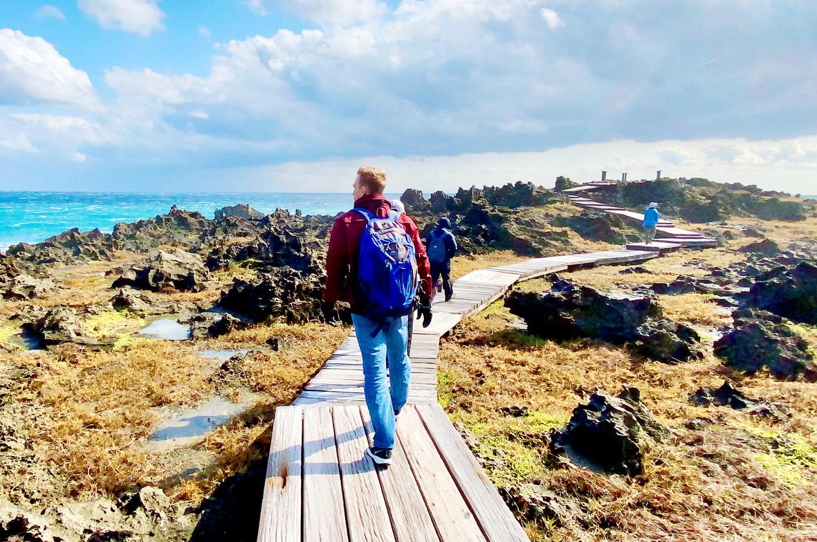
Photo courtesy of Jessie Chung
The coastal walk begins at the site of a former Coast Guard station, abandoned after Typhoon Meranti struck in 2016. The coast here is an unusual blend of coral and sandstone, eroded unevenly by the wind and waves. The angled plateaus, honeycomb erosion patterns and fanciful animal shapes in the rocks will be familiar to those who have already visited Jialeshuei Scenic Area, and make for beautiful photographs, both up close and from afar.
Traces of human activity are visible here and there: abandoned power poles, fishing tackle and the leftovers of a ship that ran aground nearby several years ago. Still, this stretch of coastline remains relatively untouched and walking on this trail, accompanied by only the sound of the surf, will leave you feeling a world away from Kenting’s crowded beaches.
NANREN MOUNTAIN: AN OASIS
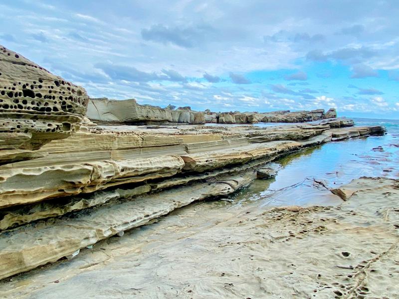
Photo courtesy of Jessie Chung
Further north along County Road 200 is the access road for the Nanren Mountain Ecological Protection Area. The three-hour guided excursion here covers the most distance of all the protected area visits at nearly nine kilometers round trip. The forest here is rich with both animal and plant life: dragonflies, spiders, butterflies, lizards, ferns and trees with exotic-looking fruits. This protected area appears to be the most biologically diverse of them all.
The area also contains three perennial freshwater lakes, with the largest being Nanren Lake. The area around these lakes is flanked by vibrant green grass and backed by gentle rolling hills. Thanks to the limit on the number of visitors, total lack of development and knowledgeable guides, a visit to the Nanren area can be a peaceful retreat, an excellent learning opportunity or anything in between.
BITOU GRASSLAND: A SANDY BAY WITH A DARK PAST
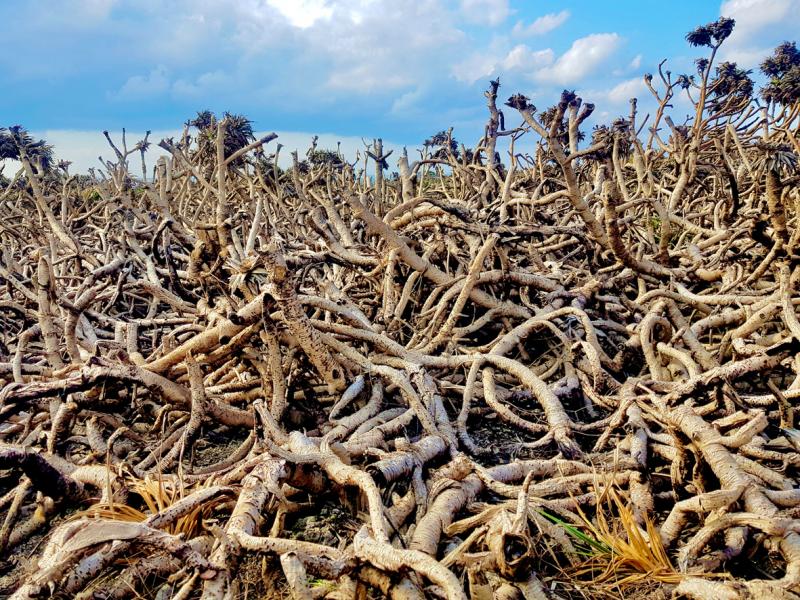
Photo: Tyler Cottenie
This ecological protection area is situated just inside the northern border of Kenting National Park, near the town of Jioupeng (九棚) and the sand dunes lining the shores of Bayao Bay (八瑤灣). Though the population here is so low now that water buffalo actually outnumber people, the area was nevertheless the site of an important event in Taiwan’s history.
It was in this very bay in 1871 that the shipwrecked Ryukyuan sailors of the Mudan Incident first came ashore. Only 12 of 66 made it back to Japan alive. Three years later, the Japanese sent an expedition to Taiwan, ostensibly to punish the Paiwan Aborigines for killing their sailors. However, this military campaign also effectively chipped away at Qing Dynasty influence in the region, allowing Japan to easily annex the Ryukyu Islands and encouraging expansionist efforts that would culminate in the annexation of Taiwan itself 21 years later. Our guide went beyond the standard colonial narrative, adding context and nuance to the story based on oral history, local cultural practices and other recent research findings.
In addition to this more factual account of a historical event, we were treated to a more fanciful account of a tragic romance between a local chief’s daughter and a shipwrecked Dutch sailor. The common name of a local plant comes from this story, as its flower appears to be missing its top half, just as these lovers were forever missing their better half.
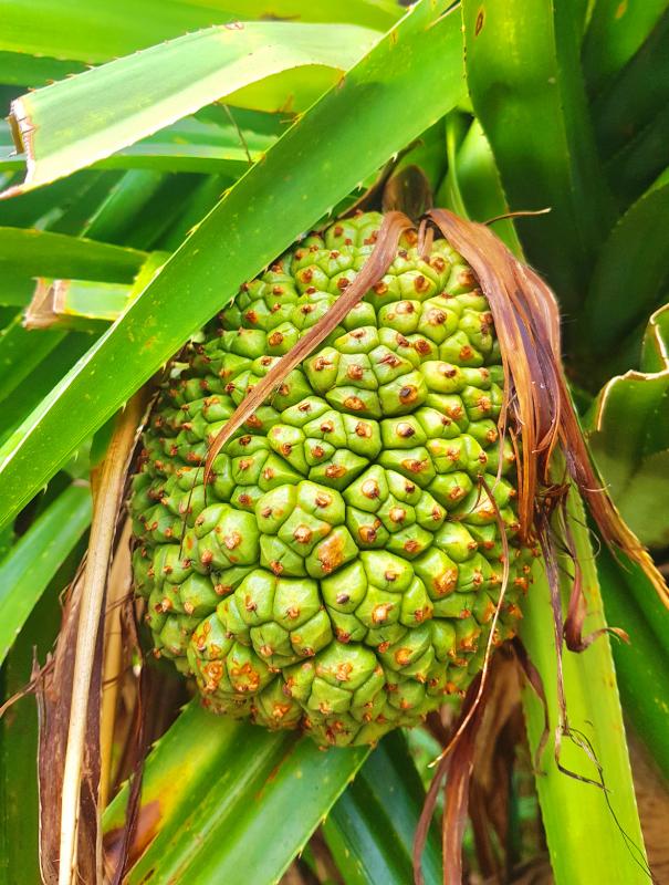
Photo: Tyler Cottenie
The guide introduced many other plants along our walk, along with the often-humorous origins of their common names. We were also acquainted with traditional uses of local plants, for pillows, whistles, pot scrubbers and more.
The walk takes visitors from the sandy coast and up through denser vegetation before eventually ascending to an open grassland area. Local livestock keep this grass trimmed short, while wild macaques eating the adjacent screw pine prevent it from taking over the open area.
Be warned: the guide may insist on visitors taking photos here in a variety of poses, including the infamous bow pose from Titanic. The lush green carpet combined with the high vantage point and sandy Bayao Bay in the background make this area especially picturesque. From the grassland, visitors descend through an active military area back to the public road near the coast.

Ajay Verma, a consultant gastroenterologist at Kettering general hospital in Northamptonshire, says our gut is a “complex machine.” “It is constantly providing us with the nutrition we need, initially to grow and develop, and then for us to survive, thrive and repair from injury and illness.” How can we keep it functioning well? Put simply: “Make sure what you put into it is balanced, and that you clear out its waste products adequately,” Verma says. “In a general gastroenterology clinic, the most common conditions we see are irritable bowel syndrome (IBS), gastroesophageal reflux disease, inflammatory bowel disease and constipation,” says Nisha
The arithmetic is straightforward and uncomfortable. By the end of 2025, Taiwan had committed itself to a 50-30-20 electricity mix — half natural gas, 30 per cent coal, 20 per cent renewables. The Ministry of Economic Affairs’s (MOEA) own monthly energy reports tell a different story. Natural gas reached 47.8 per cent of generation last year. Coal stood at 35.4 per cent, comfortably above its target ceiling. Renewables came in at 13.1 per cent, well short of the 20 per cent Taipei had pledged a decade earlier. Installed renewable capacity reached roughly half of the 12 gigawatts (GW) the government

Last week US President Donald Trump was asked by a reporter whether he would speak on the phone to the President of Taiwan. “l’ll speak to him. I speak to everybody. We have that situation very well in hand,” Trump said. This marked the second time in a couple of weeks he had said he would talk to the President of Taiwan. In 2016 he famously took a call from then-president Tsai Ing-wen (蔡英文), when he was president-elect. Despite warnings that the apocalypse was nigh because of a phone call, the world quickly forgot about the conversation between two democratically-elected presidents.

Taiwan’s drone exports are taking off, fuelled by the war in Ukraine, as Taiwanese companies seek a stake in the fast-growing global market for unmanned aerial vehicles (UAV). Low-cost drones used for reconnaissance and strikes are in high demand as governments around the world boost defense spending in the face of intensifying conflicts. A relative new player in the increasingly competitive industry, Taiwan’s pitch is to be an “Asian hub” for the production of UAVs and components free of Chinese materials, or “non-red.” That means its UAVs can be up to three times more expensive than their Chinese competitors, like the world’s biggest