Today’s ride was recommended by Leo Huang (黃博駿), a 31-year-old resident of the Sijhih District (汐止) in New Taipei City.
Five years ago, Huang, then a dedicated meat-lover with plenty more beef, pork and seafood dishes left on his “culinary bucket list,” challenged himself to give up meat.
That was hard enough, he says, though he is now part-owner of a vegetarian restaurant that focuses on “showing meat-eaters that tasty alternatives are available.” His new challenge for this year is the Tour of the Dragon, a 255km bike race traversing four mountain passes in Bhutan, all at high altitude.
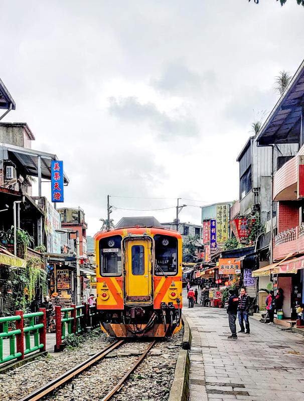
Photo: Mark Caltonhill
This may well prove to be a little harder than cutting meat from his diet. In 2019, just 37 people finished. Moreover, when Huang decided to attempt this event last year, he didn’t own a bicycle and hadn’t ridden a YouBike further than the nearest MRT station.
HISTORIC CEMETERY
We arrange to meet near the top of Fude Cemetery (富德公墓). My climb from central Taipei takes me past thousands of graves, such as those of Yulbars Khan, a Uyghur chieftain who fought with the Chinese Nationalist Party (KMT) during the Chinese Civil War and was later appointed Governor of Xinjiang Province; Pai Chung-hsi (白崇禧), one-time warlord and later Chiang Kai-shek’s (蔣介石) defense minister; and, until his remains were recently moved to his hometown in Yilan, that of Japanese-era Taiwan nationalist Chiang Wei-shui (蔣渭水), to whom a memorial still stands.
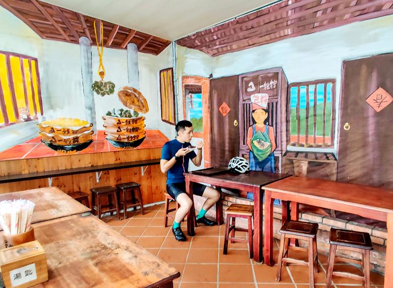
Photo: Mark Caltonhill
We can probably spend all day exploring but, with Bhutan’s mountain climbs less than nine months away, Huang has a more strenuous ride in mind. We descend to Highway 106 running alongside Jingmei River (景美溪) to Shenkeng (深坑) and then Shihding (石碇).
Finding the locally renowned restaurant Yilizong (一粒粽) is open and has vegetarian sticky-rice options, Huang takes a snack among the murals depicting a traditional Taiwan eatery.
In the late 19th century, Shihding was an important stop on the southern section of the Taipei-to-Yilan trail. And, even though traffic now shoots past high overhead on National Highway 5 (also called the Chiang Wei-shui Memorial Freeway), there is an Old Street catering to tourists. The township’s name, meaning “stone anchor,” further alludes to the barges that took agricultural produce and, later, coal downstream.
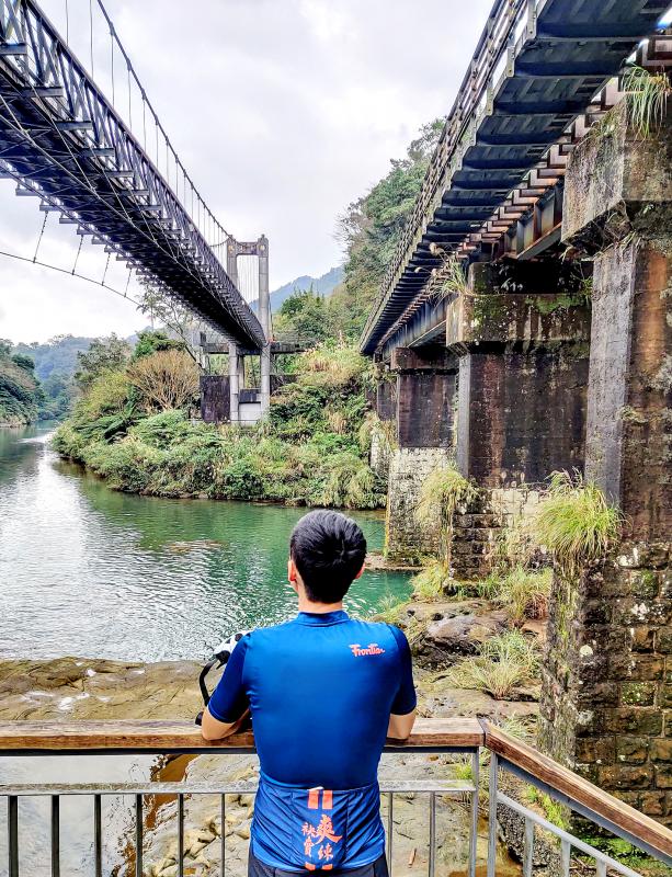
Photo: Mark Caltonhill
JINGTONG’S ‘BLACK GOLD’
We turn back to follow the 106 as it climbs eastward beside the tributary Yongding River (永定溪), and on to Jingtong (菁桐), since it is steady ascents that Huang must practice. Asked if he expects to be among this year’s three dozen finishers, he says that this is not really the point of his participation, which is more about process, about the journey, about self-discovery.
Like Shihding, Jingtong took off with the discovery of coal deposits early in the period of Japanese rule. This “black gold” led to construction in the 1920s of the Pingsi Railway Line, which rises more than 300 meters over the 13 kilometers from Sandiaoling (三貂嶺) on the Eastern Line. Jingtong is the terminal stop and its sole remaining original Japanese-era station building.
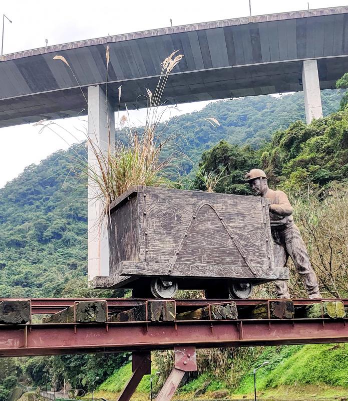
Photo: Mark Caltonhill
There is a visitor center that introduces the area’s history and culture, but more popular with most tourists seems to be the station, Old Street and coal industry buildings as backdrops for selfies.
PINGSI STATION
Next up is Pingsi (平溪) Station. I should perhaps confess here that for much of my time in Taiwan I thought Pingsi was the river’s name, a self-describing “Flat River.” But, there again, for a few years I thought that Keelung River (基隆河) in Taipei must run eastward to empty into the sea at Keelung Harbor.
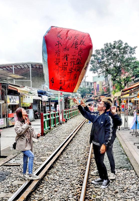
Photo: Mark Caltonhill
Both wrong. This is, in fact, the same Keelung River, here running eastward from Jingtong until it reaches Rueifang District (瑞芳), less than 2 kilometers from the sea, where it abruptly swings northward and then westward for over 40 kilometers, before joining the Tamsui River and emptying into the ocean on the northwest coast.
Pingsi’s name, Huang reads from one of the numerous information boards, actually derives from the fact that both above and below this point the river is steeper and more turbulent, and so is a “tranquil river” at Pingsi. My bad.
SKY LANTERNS
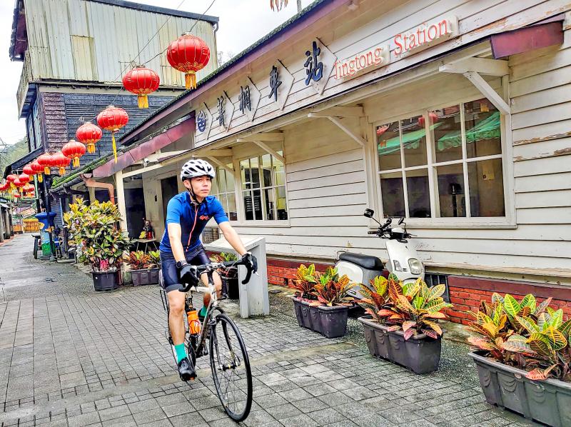
Photo: Mark Caltonhill
Pingsi’s economy in the post-coal era is based on tourism but, unlike just about everywhere from Shenkeng and Yonghe to Taichung and Tainan, has nothing to do with food. Rather, it involves buying a paper lantern, writing auspicious words on the sides, lighting some kerosene-soaked paper underneath and watching it ascend into the sky.
Various origins are offered as to why this practice, said to have begun as a system of military signaling by Zhuge Liang (諸葛亮) in third-century China, is associated with Pingsi. According to the visitor center, bandits roamed this area in earlier centuries causing local people to hide in the afforested hillsides, who then used lanterns to let each other know when the coast was clear.
In any case, tens of thousands of these lanterns are launched around Lunar New Year, and even on a soggy winter Monday they can be seen rising every few minutes from the valley’s various townships. Huang, who is active in a number of environmental groups, says that volunteers spend weeks after New Year collecting the myriad lantern corpses from trees and power lines throughout the valley and beyond.
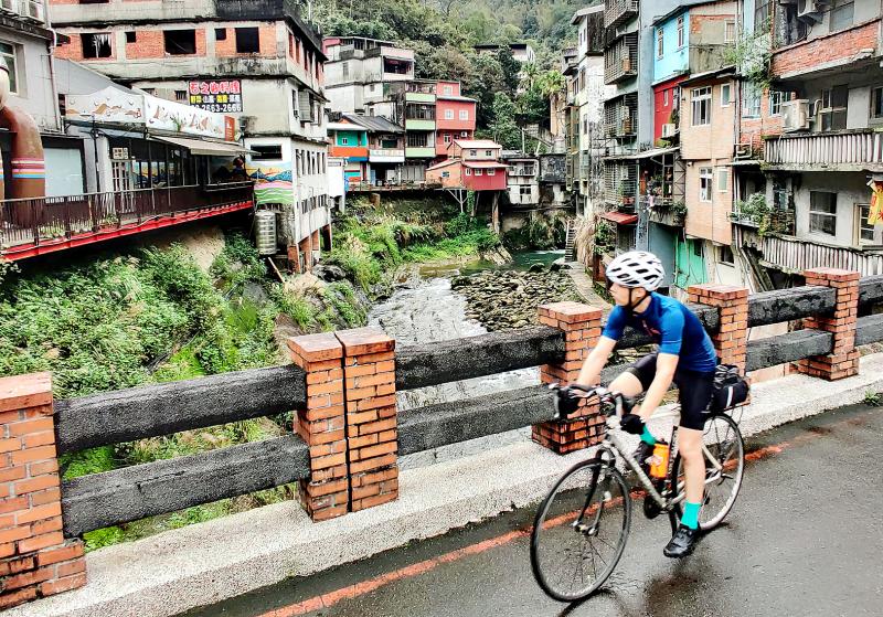
Photo: Mark Caltonhill
Similar lanterns made of biodegradable materials have been developed in recent years, Huang says, but, looking in local stores for an example to show me, he couldn’t find any.
SHIHFEN’S OLD STREET
Three stations further down is Shihfen (十分), which has a mandatory Old Street but similarly lacks any tofu, soymilk or sun cake. Instead, it relies on Taiwan’s largest cascade waterfall to attract visitors.
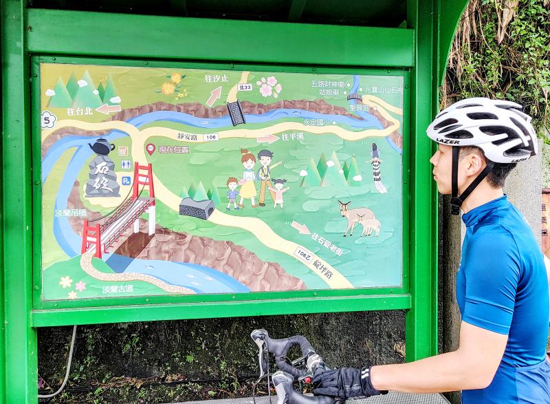
Photo: Mark Caltonhill
Despite having lived just 40 kilometers away for many years and written numerous travel articles for various publications, this is my first visit. Huang chose it as the destination of our ride, remembering a family visit during his school years spent living with his grandmother in Yilan County.
Fortunately, the access road that until recently was privately owned has been acquired by New Taipei City so admission is now free, meaning this magnificent conjunction of waterfall in full after-rain majesty with historic coal-industry structures and trains passing nearby, is finally worth a visit even for this old Scrooge.
Mark Caltonhill bikes, and writes, and writes about bikes.
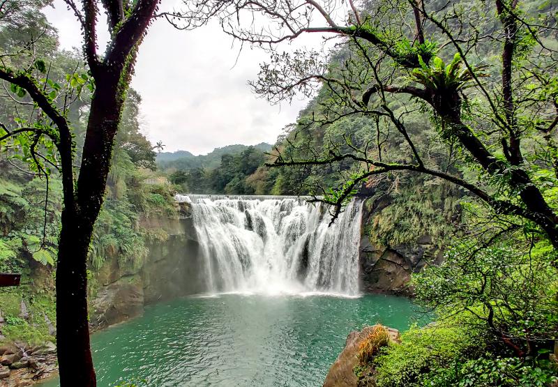
Photo: Mark Caltonhill
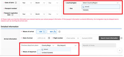
Jason Han says that the e-arrival card spat between South Korea and Taiwan shows that Seoul is signaling adherence to its “one-China” policy, while Taiwan’s response reflects a reciprocal approach. “Attempts to alter the diplomatic status quo often lead to tit-for-tat responses,” the analyst on international affairs tells the Taipei Times, adding that Taiwan may become more cautious in its dealings with South Korea going forward. Taipei has called on Seoul to correct its electronic entry system, which currently lists Taiwan as “China (Taiwan),” warning that reciprocal measures may follow if the wording is not changed before March 31. As of yesterday,

The Portuguese never established a presence on Taiwan, but they must have traded with the indigenous people because later traders reported that the locals referred to parts of deer using Portuguese words. What goods might the Portuguese have offered their indigenous trade partners? Among them must have been slaves, for the Portuguese dealt slaves across Asia. Though we often speak of “Portuguese” ships, imagining them as picturesque vessels manned by pointy-bearded Iberians, in Asia Portuguese shipping between local destinations was crewed by Asian seamen, with a handful of white or Eurasian officers. “Even the great carracks of 1,000-2,000 tons which plied
It’s only half the size of its more famous counterpart in Taipei, but the Botanical Garden of the National Museum of Nature Science (NMNS, 國立自然科學博物館植物園) is surely one of urban Taiwan’s most inviting green spaces. Covering 4.5 hectares immediately northeast of the government-run museum in Taichung’s North District (北區), the garden features more than 700 plant species, many of which are labeled in Chinese but not in English. Since its establishment in 1999, the site’s managers have done their best to replicate a number of native ecosystems, dividing the site into eight areas. The name of the Coral Atoll Zone might
Nuclear power is getting a second look in Southeast Asia as countries prepare to meet surging energy demand as they vie for artificial intelligence-focused data centers. Several Southeast Asian nations are reviving mothballed nuclear plans and setting ambitious targets and nearly half of the region could, if they pursue those goals, have nuclear energy in the 2030s. Even countries without current plans have signaled their interest. Southeast Asia has never produced a single watt of nuclear energy, despite long-held atomic ambitions. But that may soon change as pressure mounts to reduce emissions that contribute to climate change, while meeting growing power needs. The