May 26 to June 1
When the Qing Dynasty first took control over many parts of Taiwan in 1684, it roughly continued the Kingdom of Tungning’s administrative borders (see below), setting up one prefecture and three counties. The actual area of control covered today’s Chiayi, Tainan and Kaohsiung. The administrative center was in Taiwan Prefecture, in today’s Tainan.
But as Han settlement expanded and due to rebellions and other international incidents, the administrative units became more complex. By the time Taiwan became a province of the Qing in 1887, there were three prefectures, eleven counties, three subprefectures and one directly-administered prefecture, with the administrative seat planned at today’s Taichung. However, due to various economic and geographic reasons, the capital ended up being moved to Taipei in 1894 — and has remained there since.
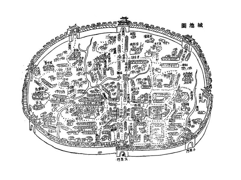
Photo: Wikimedia Commons
After the Qing ceded Taiwan to the Japanese in 1895, much of central and eastern Taiwan were still controlled by Indigenous communities, and it would take the Japanese 20 more years to bring the entire island under its fold.
‘RECEIVING THE HEAVENS’
Established by Ming loyalist warlord Cheng Cheng-kung (鄭成功, also known as Koxinga), the Kingdom of Tungning (東寧), basically inherited the lands of the Dutch which they defeated in 1662. According to Changes in Taiwan’s Administrative Divisions (台灣的行政區變遷) by Shih Ya-hsuan (施雅軒), they renamed Fort Provintia “Chengtian Prefecture” (承天府, receiving the heavens), and to the north was Tianxing County (天興, heavenly prosperity) and to the south Wannian (萬年, ten-thousand years).
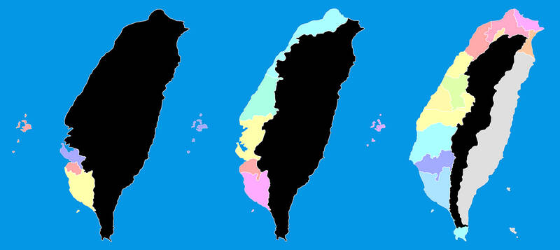
Photo: Wikimedia Commons
The administrative institutions were located in Chengtian Prefecture. Cheng’s son Cheng Ching (鄭經) elevated the two counties to prefectures and added “pacification commissions” in lands bordering Indigenous territory as well as Penghu.
In 1683, Qing Dynasty admiral Shih Lang (施琅) destroyed the Kingdom of Tungning. The emperor and other officials had no interest in annexing Taiwan, one disparaging it as a “speck of dirt on the outer seas with naked, tattooed savages not worthy of spending our resources on.” Shih extolled Taiwan’s strategic location and abundant natural resources, adding that if left alone, pirates or other foreigners might occupy it and cause trouble for the Qing.
Shih may have had other motives (see “Taiwan in Time: The admiral’s secret plan,” Sept. 23, 2018), but in 1684, Taiwan officially became part of the Qing Empire.
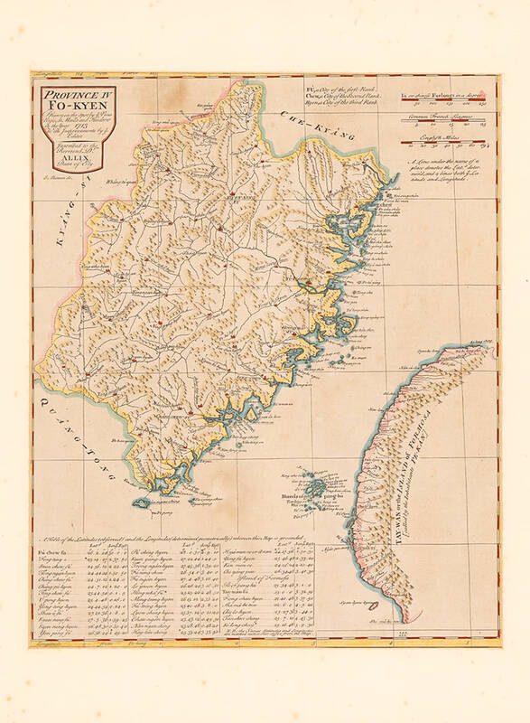
Photo: Wikimedia Commons
REBELLIONS AND UNREST
On May 27, 1684, the Qing designated the island as Taiwan Prefecture under Fujian Province. Chengtian Prefecture was renamed Taiwan County and remained the administrative seat, Tianxing was renamed Chuluo (諸羅) after a local Indigenous settlement and Wannian became Fengshan (鳳山). Chuluo nominally controlled a large swath of land, stretching from the today’s Yanshui River (鹽水溪) in Tainan all the way up the west coast to Keelung.
Officials were sent to Taiwan on three-year terms, and were not allowed to bring their families. It was the same with soldiers. The construction of stone fortifications was banned, in fear that rebels or remaining Ming loyalists might use them as bases. As a result, early cities were guarded with bamboo walls; this would change after the Lin Shuang-wen Rebellion (林爽文事件) of 1788.
This setup remained in place for the next 40 years, until “Duck King” Chu Yi-kuei (朱一貴) rose up against the Qing in April 1721. The unrest was quelled within two months, but this alarmed Qing officials who began discussing how to tighten security.
Officials such as Lan Ting-yuan (藍鼎元) and Wu Ta-li (吳達禮) urged the emperor to establish a new county north of the Huwei River (虎尾溪) as the Han population was growing and expanding fast. The result was Changhua County (彰化), but because the land was still too vast, Tamsui Subprefecture (淡水) was established to maintain order in the north. Curiously, the Tamsui officials still worked out of Changhua, only moving north to Hsinchu a few decades later. Around the same time, Penghu was also made a subprefecture.
Borders demarcating Han and Indigenous territories were also set up as Han settlers had seized most of the arable lowland of the west coast. They now turned their sights to the eastern mountains, leading to countless violent clashes. The government first put up stone steles, but this did not deter Han encroachment, and finally they began digging border ditches and stationing armed guards.
FOREIGN INVASIONS
After local militias helped quell the Lin Shuang-wen rebellion, the government renamed Chuluo to Chiayi (嘉義), which means “commending the righteous people.”
In 1796, Wu Sha (吳沙) managed to overpower Indigenous resistance and enter today’s Yilan; scores of Han settlers followed. This area was not under Qing jurisdiction. In 1806, the pirate Tsai Chien (蔡牽) attack Wushih Harbor (烏石港), but he was kept at bay with the help of these settlers. They also helped the Qing repulse the pirate Chu Fen (朱濆).
Over the years, they petitioned the government to set up an administrative unit in Yilan, stating that it could help better assert their maritime borders when pirate attacks were common. In 1812, Gemalan (Kavalan) Subprefecture was established.
The Mudan Incident (牡丹社事件) in 1874 (see “Paiwan reclaim a bloody past,” July 23, 2022) sparked a Japanese punitive expedition to Taiwan, which finally made the Qing realize Taiwan’s strategic importance. Taipei Prefecture was established to better control the north, and the Qing began actively pushing into Indigenous areas.
SEPARATE PROVINCE
Calls for Taiwan to become its own province had fallen on deaf ears for decades, but after the French invaded in 1884 as part of the Sino-French War, the Qing court finally agreed.
A new administration plan was drawn up, dividing Taiwan into three prefectures. The original Taiwan Prefecture was renamed Tainan, and a new Taiwan Prefecture was drawn up in central Taiwan intending to become the new provincial administrative center. Taipei Prefecture covered Taipei, Keelung, Yilan and Hsinchu.
Liu Ming-chuan (劉銘傳) found the planned site for the capital geographically suitable, but it was not close to water sources, making it difficult to transport materials to build new offices, writes Chuang Chi-fa (莊吉發) in “Examining adjustments in Taiwan’s Qing-era administrative regions from National Palace archives” (從故宮檔案看清代台灣行政區域調整). It was also sparsely populated with little commercial activity.
Liu’s priority was to finish building the north-south railroad to bring prosperity to the area first. But his successor, Shao Yu-lian (邵友濂) wanted to make Taipei the capital, citing similar issues. Taipei was already well-developed and had a railway that reached Hsinchu, and eventually Shao’s suggestion was accepted.
Taiwan in Time, a column about Taiwan’s history that is published every Sunday, spotlights important or interesting events around the nation that either have anniversaries this week or are tied to current events.
Ajay Verma, a consultant gastroenterologist at Kettering general hospital in Northamptonshire, says our gut is a “complex machine.” “It is constantly providing us with the nutrition we need, initially to grow and develop, and then for us to survive, thrive and repair from injury and illness.” How can we keep it functioning well? Put simply: “Make sure what you put into it is balanced, and that you clear out its waste products adequately,” Verma says. “In a general gastroenterology clinic, the most common conditions we see are irritable bowel syndrome (IBS), gastroesophageal reflux disease, inflammatory bowel disease and constipation,” says Nisha
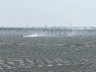
The arithmetic is straightforward and uncomfortable. By the end of 2025, Taiwan had committed itself to a 50-30-20 electricity mix — half natural gas, 30 per cent coal, 20 per cent renewables. The Ministry of Economic Affairs’s (MOEA) own monthly energy reports tell a different story. Natural gas reached 47.8 per cent of generation last year. Coal stood at 35.4 per cent, comfortably above its target ceiling. Renewables came in at 13.1 per cent, well short of the 20 per cent Taipei had pledged a decade earlier. Installed renewable capacity reached roughly half of the 12 gigawatts (GW) the government

Last week US President Donald Trump was asked by a reporter whether he would speak on the phone to the President of Taiwan. “l’ll speak to him. I speak to everybody. We have that situation very well in hand,” Trump said. This marked the second time in a couple of weeks he had said he would talk to the President of Taiwan. In 2016 he famously took a call from then-president Tsai Ing-wen (蔡英文), when he was president-elect. Despite warnings that the apocalypse was nigh because of a phone call, the world quickly forgot about the conversation between two democratically-elected presidents.
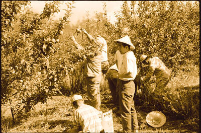
May 25 to May 31 Few believed that apples could be cultivated on a commercial scale in Taiwan’s high mountains. When horticulturalist Cheng Chao-hsiung (程兆熊) first proposed the idea in 1955, both American and Taiwanese colleagues dismissed it as implausible, arguing that temperate fruit could not be reliably grown on a subtropical island, especially on rugged terrain. However, it was this terrain in the Central Mountain Range where many Chinese Civil War veterans were resettled in the late 1950s. With limited job prospects and no family in Taiwan, they were placed on cooperative farms aimed toward self-sufficiency. Some say the conditions