On the day I rode a 125cc two-wheeler to 2,312m above sea level, the northwestern corner of Taitung County wasn’t merely beautiful. It was “renounce all worldly possessions and walk out on your family, if that means you can stay” sublime.
At first light in Chihshang (池上), I rode through jacket-dampening fog. Outside the town, I escaped the morning mists, and zipped inland on an empty road.
In the space of just under 6km, Provincial Highway 20A (20甲) exits Chihshang, passes farms, crosses the Sinwulu River (新武呂溪), and merges into Provincial Highway 20. The latter road is also known as the South Cross-Island Highway (南橫公路).
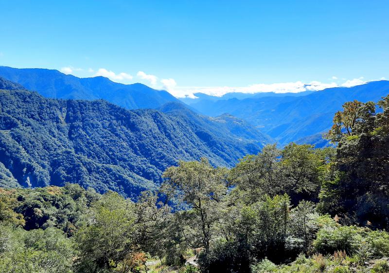
Photo: Steven Crook
Turning right onto Highway 20, I spotted the 199km marker and a traffic sign that pointed to Tainan, 204km away and on the other side of the Central Mountain Range. That sign predates Typhoon Morakot, a once-in-a-lifetime storm that wrought disaster across the south in the summer of 2009.
Since Morakot, the high-altitude section of the South Cross-Island Highway has been officially closed to through-traffic. In the first year or two after the typhoon, a handful of brave motorists got their vehicles all the way across, but further landslides occurred around 2012. These didn’t deter outdoors types, several of whom risked fines by evading the checkpoint outside Meishankou (梅山口) in Kaohsiung’s Taoyuan District (桃源). Some hiked to Taitung County; a few rode bicycles.
I’m a law-abiding person, so I didn’t return to the stretch of Highway 20 between Meishankou and Tianchih (天池) — also on the Kaohsiung side, but higher in the Central Mountain Range — before it’s formal reopening to sightseers in January this year (see “Ascending to ‘heaven’s pond’” in the Feb. 21, Taipei Times). Between Morakot and last week, I didn’t once set foot or tire on the road’s eastern half.
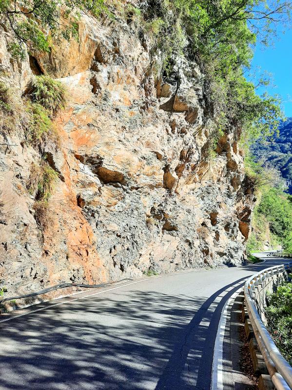
Photo: Steven Crook
The Ministry of Transportation and Communications has said it aims to have the entire South Cross-Island Highway open to the general public before the end of next year.
Opposite the police station that monitors the intersection between highways 20A and 20, a bilingual notice reminds road-users: “Access to Siangyang (向陽) only.” The distance from central Chihshang to Siangyang is approximately 57km. Even allowing for the steep gradients and tight corners I’d need to negotiate slowly, I expected to have plenty of time to enjoy the landscape, and still complete the roundtrip before dusk.
I halted very briefly at the Fengban Monument to Anti-Japanese Resistance (逢?抗日紀念碑), which celebrates Bunun Aboriginal clans who pushed back against oppressive colonial rule in 1919, and not at all at Sinwu (新武), where a sign told me I was 412m above sea level.
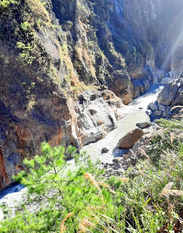
Photo: Steven Crook
Around the 192.5km marker, I stopped to look at a spot where I camped a couple of times, long before gravel washed down by Morakot raised the riverbed. Turning my attention to the south side of the road, I saw an information board introducing the Guanshan Formosan Date Palm Reserve (關山台灣海棗自然保護區).
Like many other species, the Formosan date palm has suffered from deforestation and development. Around 2,200 specimens survive in this 54-hectare conservation zone, which was established in 1970. I was tempted by the footpath leading into the reserve, but the minimum fine for unauthorized entry is NT$50,000.
On every previous trip through Wulu Gorge (霧鹿峽谷), I was on a bus or hitching lifts. This time, I could stop wherever and whenever I wanted, and give this geological marvel the attention it deserves. Between the 184km marker and the 181km marker, the scenery is almost as good as Taroko Gorge, with far fewer cars and people.
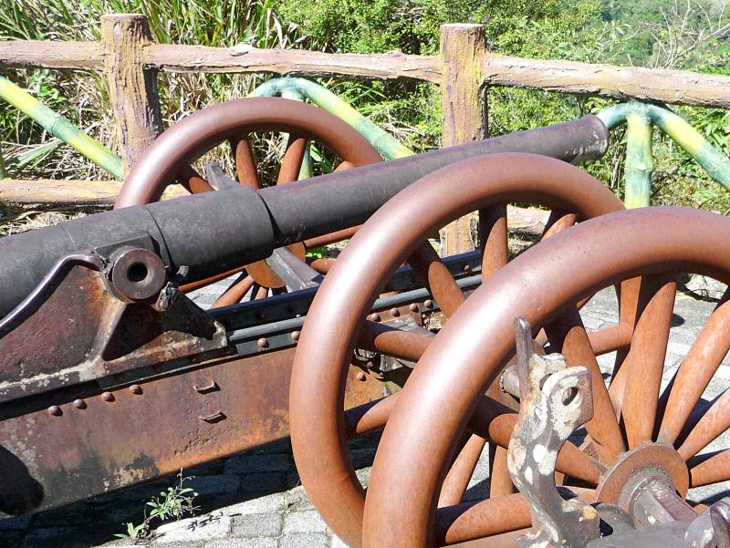
Photo: Steven Crook
In several places, sulfurous water has stained the cliffs. If you’d like to soak your feet in a hot spring, the best place to do it is by the 179km marker, where there’s a free-of-charge, government-maintained outdoors footbath.
Pushing on, I passed the plateau which hosts the Bunun settlement of Lidao (利稻; altitude 1,068m). From there, Highway 20 switchbacks up to Motian (摩天; 1,546m above sea level), where there’s no permanent village.
Motian has hardly any trees — the slopes were cleared and terraced long ago so cabbages could be cultivated — but the rest of the ride took me through alluring temperate woodlands. Liyuan (栗園), near the 159km marker, is 1,793m above sea level. Almost 10km further on, I came to a sign that announced my arrival at Siangyang. It listed the altitude as 2,312m.
The entrance to Siangyang National Forest Recreation Area (向陽國家森林遊樂區) was right around the corner. Just beyond it, next to the 149km marker, a rope across the asphalt signaled the end of legally accessible highway. When I asked a workman if I might walk a short way beyond to take some photos, his refusal was friendly but emphatic.
Siangyang National Forest Recreation Area is temporarily closed to visitors while its facilities are renovated, so there wasn’t much reason to hang around.
For parts of the descent, I freewheeled downhill, and not just to save gas and reduce carbon emissions. The quieter I moved, the greater my chances of seeing some wildlife. However, the only interesting non-humans I sighted were a pair of Mikado pheasants and a single macaque, all near Wulu Gorge.
I had vague recollections of Wulu (霧鹿) being a more attractive village than Lidao, so when I saw the sign for Wulu Fort Memorial Park (霧鹿砲台紀念公園) near the 186km marker, I made a detour. Finding the park, which is 1.8km from the highway, might not be easy if you can’t read any Chinese; only the sign on the main road is bilingual.
The term “fort” is misleading. During the years-long, low-intensity conflict between the Japanese and the Bunun, the colonial power placed two artillery pieces atop this hillock, almost 900m above sea level, so they could bombard uncooperative Aborigines. But there wasn’t much actual fortification, it seems.
The weapons, which the Japanese captured from the Russians during the Russo-Japanese War of 1904-1905, are still here. Both have calibers of about 60mm, but they’re not identical. The on-site information panel doesn’t say if, after the Japanese installed the guns here in 1927, they fired shells they’d captured with the artillery pieces, or if they were manufacturing their own.
The Chinese-style concrete pavilion that now decorates this spot is incongruous. Rather than sit on one of its benches, I used my time trying to get a decent photo bringing together the Central Mountain Range and the artillery pieces that colonial forces had pointed at the area’s indigenous inhabitants. That, I figured, would neatly sum up the history and geography of this glorious region.
Steven Crook has been writing about travel, culture and business in Taiwan since 1996. He is the author of Taiwan: The Bradt Travel Guide and co-author of A Culinary History of Taipei: Beyond Pork and Ponlai.
June 2 to June 8 Taiwan’s woodcutters believe that if they see even one speck of red in their cooked rice, no matter how small, an accident is going to happen. Peng Chin-tian (彭錦田) swears that this has proven to be true at every stop during his decades-long career in the logging industry. Along with mining, timber harvesting was once considered the most dangerous profession in Taiwan. Not only were mishaps common during all stages of processing, it was difficult to transport the injured to get medical treatment. Many died during the arduous journey. Peng recounts some of his accidents in

“Why does Taiwan identity decline?”a group of researchers lead by University of Nevada political scientist Austin Wang (王宏恩) asked in a recent paper. After all, it is not difficult to explain the rise in Taiwanese identity after the early 1990s. But no model predicted its decline during the 2016-2018 period, they say. After testing various alternative explanations, Wang et al argue that the fall-off in Taiwanese identity during that period is related to voter hedging based on the performance of the Democratic Progressive Party (DPP). Since the DPP is perceived as the guardian of Taiwan identity, when it performs well,

The Taiwan People’s Party (TPP) on May 18 held a rally in Taichung to mark the anniversary of President William Lai’s (賴清德) inauguration on May 20. The title of the rally could be loosely translated to “May 18 recall fraudulent goods” (518退貨ㄌㄨㄚˋ!). Unlike in English, where the terms are the same, “recall” (退貨) in this context refers to product recalls due to damaged, defective or fraudulent merchandise, not the political recalls (罷免) currently dominating the headlines. I attended the rally to determine if the impression was correct that the TPP under party Chairman Huang Kuo-Chang (黃國昌) had little of a

At Computex 2025, Nvidia CEO Jensen Huang (黃仁勳) urged the government to subsidize AI. “All schools in Taiwan must integrate AI into their curricula,” he declared. A few months earlier, he said, “If I were a student today, I’d immediately start using tools like ChatGPT, Gemini Pro and Grok to learn, write and accelerate my thinking.” Huang sees the AI-bullet train leaving the station. And as one of its drivers, he’s worried about youth not getting on board — bad for their careers, and bad for his workforce. As a semiconductor supply-chain powerhouse and AI hub wannabe, Taiwan is seeing