Despite the not unreasonable claims among us northerners that Taipei is (and always will be) Taiwan’s greatest city, Kaohsiung is a pretty awesome place too, once you start exploring it. Taipei may have the larger number of historic buildings, the best public transport system and by far the finer range of day hikes and excursions. But look below the surface glitz and color of modern Kaohsiung, and it’s a surprisingly varied and interesting place, with a lot to see and explore.
Shoushan (壽山) is one of several outcrops of limestone (or rather ancient coral) that occur in southern Taiwan. The ridge, about six kilometers long and two kilometers wide, was lifted above the surface of the ocean eons ago, and the exposed rock has since been cracked by earthquakes and dissolved by rain to form a weird landscape of narrow clefts, jagged coral formations and caves. Sadly, those last features aren’t open to the public, and neither is the mysterious northern half of the ridge, which is still a controlled military area. The accessible area is still a great place for exploring, though, especially off the well-trodden main trails.
GEOLOGICAL RICHES

Photo: Richard Saunders
Shoushan, which is rich in geological, ecological and (pre)historic interest, became Taiwan’s first National Nature Park (established in October 2009). It’s divided into five distinct areas, all on the western side of Kaohsiung City. Shoushan ridge itself is the largest protected area, but two other smaller uplifted coral hills — Guishan (龜山) and Mount Banping (半屏山) — and even several historic relics, including part of the old walled city of Zuoying (左營) and a couple of minor prehistoric sites, also lie within the park’s multiple boundaries.
The long, wooded ridge of Shoushan is a conspicuous feature from many areas of Kaohsiung, but the three main trailheads all take a little effort to seek out, since they’re not especially well signposted. The easiest entry point to locate starts near the city zoo, at the southern end of the ridge, while the other two are close to each other, about half-way up the eastern side of the ridge. Once you’ve finally found a way onto the mountain, signage improves considerably: English language maps and signs are generously scattered along paths all over the mountain, so getting around is straightforward.
The best place to start exploring Shoushan is probably from the middle trailhead of the three, which starts at a large car park beside Qianguang Temple (千光宮). Walk past the unmanned visitor center, which has a map of the National Nature Park, and a small display explaining some of the geology, flora and fauna of the ridge, and take a raised wooden walkway that climbs quite steeply above the car park, past a huge old banyan tree. Shortly the boardwalk turns into an unattractive, dusty track winding up the wooded hillside. Hang in there; it does get more interesting later on.
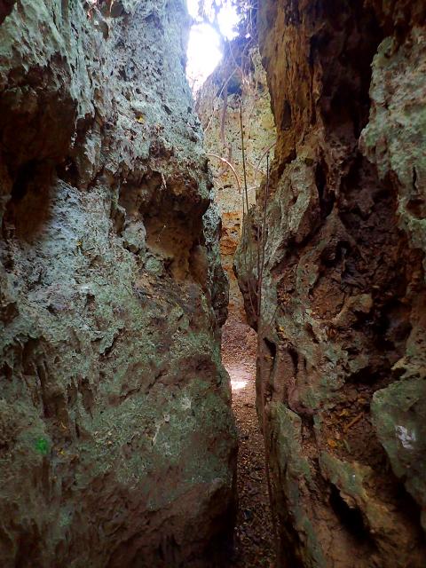
Photo: Richard Saunders
FORMOSAN MACAQUES
In about 20 minutes the track passes the Four Banyans (四棵榕), a row of old trees that provide the first good view over the city, from where several routes climb the hillside for about another half hour to the more impressive Rocky Banyan (盤榕), clinging to the side of a limestone crag and usually busy with Shoushan’s famous Formosan macaques (the only species of monkey native to Taiwan).
These critters might look cute, but treat them with respect. Years of sharing the ridge with the countless hikers that come up there each day has taught them not only to have no fear of humans, but also to see them as a source of food, so keep all edibles well hidden, even away from busy monkey stations such as here.

Photo: Richard Saunders
The Rocky Banyan is a useful landmark, as it’s the place where Shoushan really starts to get interesting; most of the best caves, gorges and other formations are within easy walking distance of it. Some of these are marked on the English-language maps, but the best plan is to choose a direction, get off the wide main trails as soon as possible and simply explore.
Worth a look before leaving the Rocky Banyan area is the nearby Lotus Cave (蓮花洞), a sinkhole beside the path. From here a trail strikes north past the Monkey View Pavilion (觀猴亭; guaranteed close encounters with loads more Formosan macaques), the bluff known as Monkey Rock (猴岩) and on to the deep cleft curiously known as Thailand Valley (泰國谷), perhaps the most impressive formation on the entire ridge.
For my favorite so-far discovered portion of Shoushan, however, head west from the Rocky Banyan along a dull but flat track leading to a flat terrace called the Longevity Rest Area (長壽園). Now turn west (right) off along any of the tiny dirt trails that branch off, and start wandering along the network of rough dirt trails towards the highest point of the entire ridge (349 meters), in search of some of Shoushan’s more intriguing features such as the Tiger Cave (虎洞), Monkey Cave (猴洞) and the Mountain Pig Cave (山豬洞).
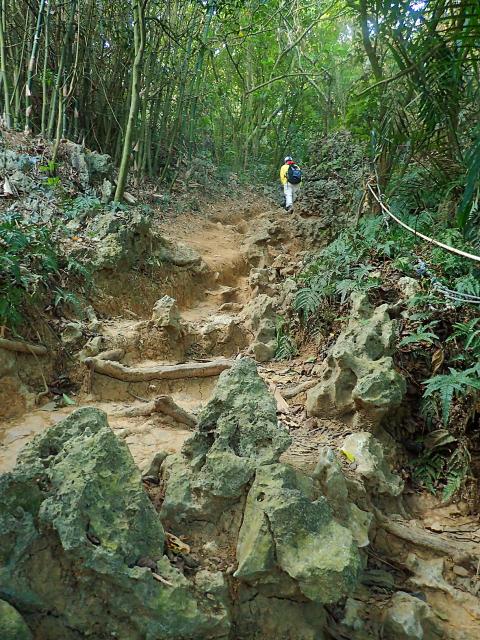
Photo: Richard Saunders
Richard Saunders is a classical pianist and writer who has lived in Taiwan since 1993. He’s the founder of a local hiking group, Taipei Hikers, and is the author of six books about Taiwan, including Taiwan 101 and Taipei Escapes. Visit his Web site at www.taiwanoffthebeatentrack.com.
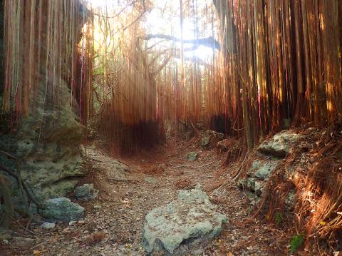
Photo: Richard Saunders
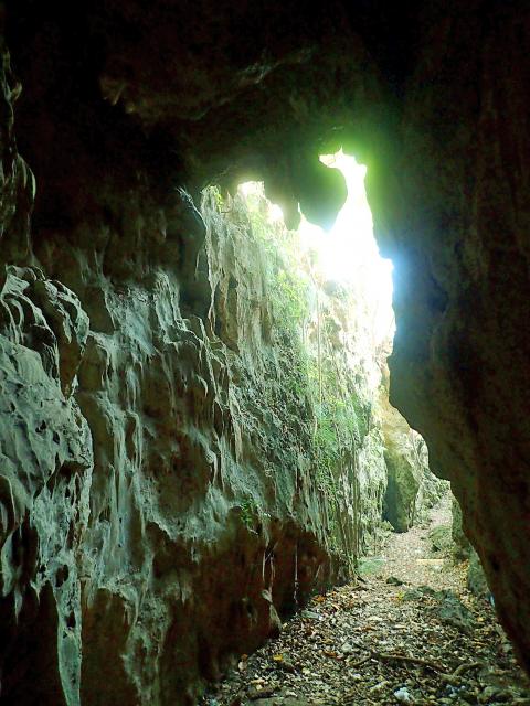
Photo: Richard Saunders

Just after 6am, I walked up to the ticket gate at Taipei Main Station and entered the Taiwan Railway platform without scanning any ticket; instead, I flashed the Sanrio Fun Rail pass on my phone to the gate worker and was admitted. I found my train and prepared to board. My destination? This very same station. I was embarking on a 13-hour journey on one of two round-the-island trains operated by ezTravel. They run each day, one counterclockwise around the island and one clockwise. They differ in a number of ways from an ordinary Taiwan Railway train and can make for
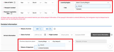
Jason Han says that the e-arrival card spat between South Korea and Taiwan shows that Seoul is signaling adherence to its “one-China” policy, while Taiwan’s response reflects a reciprocal approach. “Attempts to alter the diplomatic status quo often lead to tit-for-tat responses,” the analyst on international affairs tells the Taipei Times, adding that Taiwan may become more cautious in its dealings with South Korea going forward. Taipei has called on Seoul to correct its electronic entry system, which currently lists Taiwan as “China (Taiwan),” warning that reciprocal measures may follow if the wording is not changed before March 31. As of yesterday,
The Portuguese never established a presence on Taiwan, but they must have traded with the indigenous people because later traders reported that the locals referred to parts of deer using Portuguese words. What goods might the Portuguese have offered their indigenous trade partners? Among them must have been slaves, for the Portuguese dealt slaves across Asia. Though we often speak of “Portuguese” ships, imagining them as picturesque vessels manned by pointy-bearded Iberians, in Asia Portuguese shipping between local destinations was crewed by Asian seamen, with a handful of white or Eurasian officers. “Even the great carracks of 1,000-2,000 tons which plied
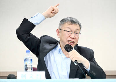
On Thursday, former Taipei mayor and founder of the Taiwan People’s Party (TPP) Ko Wen-je (柯文哲) was sentenced to 17 years in prison and had his civil rights suspended for six years over corruption, embezzlement and other charges. Seven others related to the case were also handed prison sentences, while two were found not guilty. It has been a bad week for the TPP. On Tuesday, prosecutors charged Chinese immigrant Xu Chunying (徐春鶯) with suspicion of taking part in Beijing-directed election interference. Xu has strong links to the TPP, which once offered her a party list legislator nomination. Tuesday also