"Wow." "Amazing." "Incredible."
Sit next to someone who is trying out the new, free Google Earth program for the first time, and you're likely to hear similar exclamations.
"If you're going to write about this, tell your readers to be prepared to spend a few hours in awe."
So what's all the fuss about? Put simply, Google Earth shows you the world like no other software program ever has. Download Google Earth (http://earth.google.com), and within minutes you're looking from outer space at the little blue ball we call Earth. Type a location into the "fly there" box and you zoom down from outer space, with topography, countries, and cities slowly coming into view.
But the real magic happens next. Zoom further down, and Google Earth gets more detailed -- much more detailed in many cases. This is where the exclamations of incredulity usually arise from first-time users. The program uses high resolution imagery drawn from a number of sources, including images taken by satellite and aircraft over the past three years, to give you a representation of the earth's countries, cities, towns, and streets that is detailed to the point of showing individual houses, boats, cars and trees.
"Broadband streaming technology" and "3D graphics, much like a video game, (allows) users interactively to explore their world, either their own neighborhood ... or the globe," says John Hanke, a general manager at Google who helped oversee the Earth project.
Most users are startled at the level of detail available in the program. But don't be too concerned: what you see in Google Earth isn't real-time data, nor is it so detailed that could zoom in to see yourself looking at the computer with your mouth hanging open -- at least not yet.
But you can see plenty. "I can locate my own townhouse," Medley said, exclaiming, "I could even spot my car sitting in the parking lot."
Google Earth does not offer that degree of detail for all places. Currently, selected cities and towns in the US are covered in high resolution, but greater high-resolution coverage of major areas around the world is underway and will be added in the coming months, Google notes.
A complete list of high-resolution coverage is available in the coverage list that is freely downloadable from http://earth.google.com/coverage/google_earth_coverage_list_2005-06- 07.pdf.
When starting off, choose places such as New York City, Paris or the Grand Canyon in Arizona to get a taste of the mapping detail.
According to Google, the best view you get is equivalent to a 1m distance. A little experimentation will show that you not only get a bird's eye view at street level but can also alter your perspective and zoom through the streets horizontally, as though you were looking at things from an automobile cruising about the ground.
Depending upon the speed of your computer and your Internet connection, a bit of patience may be required when first viewing a location. That's because Google Earth streams necessary data to your computer as you zoom in on a location. The small footprint of the initial installation means that you're getting basic code to run the program; as you exercise the program's features, more information is downloaded to your PC on an as-needed basis.
A status bar labeled "Streaming" along the bottom edge of Google Earth's main screen lets you know what percentage of the data currently in view is complete. The good news is that the image builds dynamically, so you can see cities, towns, topography, and even street names and buildings appear before your eyes when you first view a location.
At some point while using Google Earth, you'll probably wonder how Google can offer so much functionality free of charge. While Google is typically tight-lipped about how it monetises free offers, it's fairly easy to see how Google Earth could generate plentiful revenue streams. First, there are options in the program that allow you to display information such as coffee shops, restaurants, lodging and rental car locations in particular locations; advertisers will pay to get their information displayed in a program destined to receive the amount of attention that Google Earth will.
Also, Google Earth is currently available in three versions. In addition to the basic Google Earth, there are two retail editions: Google Earth Plus and Google Earth Pro. The Plus edition, available for US$20, includes GPS integration, allowing you to read and track locations from your GPS, high-resolution printing, customer support, and annotation capabilities.
The Pro version, which costs US$400, includes multiple terabytes' worth of imagery and 3D data depictions of the entire Earth, more than you get with the other two versions. A host of other features is available in the Pro version as well.
Google Earth will run on most PCs sold during the past two years. It does require a PC or notebook with 3D graphics capabilities for rendering the detailed topographies it provides. Full system requirements can be found at http://earth.google.com.
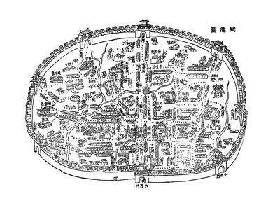
May 26 to June 1 When the Qing Dynasty first took control over many parts of Taiwan in 1684, it roughly continued the Kingdom of Tungning’s administrative borders (see below), setting up one prefecture and three counties. The actual area of control covered today’s Chiayi, Tainan and Kaohsiung. The administrative center was in Taiwan Prefecture, in today’s Tainan. But as Han settlement expanded and due to rebellions and other international incidents, the administrative units became more complex. By the time Taiwan became a province of the Qing in 1887, there were three prefectures, eleven counties, three subprefectures and one directly-administered prefecture, with

It’s an enormous dome of colorful glass, something between the Sistine Chapel and a Marc Chagall fresco. And yet, it’s just a subway station. Formosa Boulevard is the heart of Kaohsiung’s mass transit system. In metro terms, it’s modest: the only transfer station in a network with just two lines. But it’s a landmark nonetheless: a civic space that serves as much more than a point of transit. On a hot Sunday, the corridors and vast halls are filled with a market selling everything from second-hand clothes to toys and house decorations. It’s just one of the many events the station hosts,
Among Thailand’s Chinese Nationalist Party (KMT) villages, a certain rivalry exists between Arunothai, the largest of these villages, and Mae Salong, which is currently the most prosperous. Historically, the rivalry stems from a split in KMT military factions in the early 1960s, which divided command and opium territories after Chiang Kai-shek (蔣介石) cut off open support in 1961 due to international pressure (see part two, “The KMT opium lords of the Golden Triangle,” on May 20). But today this rivalry manifests as a different kind of split, with Arunothai leading a pro-China faction and Mae Salong staunchly aligned to Taiwan.

Two moves show Taichung Mayor Lu Shiow-yen (盧秀燕) is gunning for Chinese Nationalist Party (KMT) party chair and the 2028 presidential election. Technically, these are not yet “officially” official, but by the rules of Taiwan politics, she is now on the dance floor. Earlier this month Lu confirmed in an interview in Japan’s Nikkei that she was considering running for KMT chair. This is not new news, but according to reports from her camp she previously was still considering the case for and against running. By choosing a respected, international news outlet, she declared it to the world. While the outside world