An arid expanse of California desert at the southern end of the San Andreas Fault is being wired with high-tech sensors that scientists hope will tell them when the state’s sleeping giant could awaken.
The effort could not be more timely. For the past week, a swarm of more than 250 earthquakes has jiggled the desert where the first new seismic instruments were installed earlier this year.
“Even the smallest little bump shows up there,” said Bill Curtis, demonstrating the sensitivity of the new monitors with a foot-stomp that created telltale squiggles on a connected laptop.
Curtis, a field technician with the US Geological Survey (USGS), was satisfied that the newly installed instruments work.
Of the more than 300 known earthquake faults that crisscross California like a maze, the San Andreas is the premier fault line.
The nearly 1,287km fault runs from a peninsula just north of San Francisco to the Salton Sea, 200km southeast of Los Angeles.
In the first large-scale monitoring upgrade to one of the Earth’s most infamous cracks, scientists are showing unprecedented attention to the forgotten southernmost section, which has not ruptured in more than three centuries and is thought to be the most ripe to break.
Crews are hopscotching the southern San Andreas, burying motion sensors within 4.8km of the fault in hopes of catching the next “Big One.”
“We’re data-poor here,” said Ken Hudnut, a USGS geophysicist. “We don’t have the past record to tell us what’s going to happen.”
The USGS maintains a sprawling network of 300 seismic stations across the state. They automatically estimate a temblor’s size when the ground heaves and beam real-time data to a central hub in Pasadena, alerting that an earthquake has hit.
Since the southern San Andreas poses a significant danger to the roughly 20 million residents living near it, scientists decided to pepper the fault with 11 new seismic stations and update six old ones.
Each San Andreas station contains two sensors to measure speed and acceleration as well as a data-logger and a mini-computer that can process seismic signals without having to rely on the central hub.
The entire southern end upgrade will cost more than US$500,000, financed by a USGS grant. The instruments cost US$40,000 plus an extra US$15,000 for solar panels, antennas, construction and labor.
On a recent afternoon, USGS seismologist Doug Given and a team of technicians tested seismic equipment near the fast-growing Coachella Valley, a desert playground for golfers and sun-worshippers.
Surrounding them were the Mecca Hills, a maze of eroded canyons and badlands lifted up by the nonstop geologic bump and grind of the North American and Pacific plates.
The new sensor was installed near a dry creek bed on federal property next to a private mining company. The location had a line of sight to a communication tower, but it was remote enough that four-wheel drive was needed.
“It’s kind of like parking a Cadillac Escalade out here and leaving it,” Given said of the costly seismic equipment.
By clustering sensors along the southern edge, scientists hope to get faster readings of when quakes occur on the San Andreas and to better understand the science behind how faults break.
Eventually, they hope the sensors could be incorporated into an early warning system in Southern California — a goal that is still years away.
“What we’re after is measuring the ground motion,” Given said. “The closer you are to the source, the sooner you know an earthquake has begun.”
Any time a small fault next to a bigger one breaks, it slightly increases the chance of a larger quake, but that risk rapidly decreases with time.
“That doesn’t mean this section of the San Andreas is the next to go,” Hudnut said. “The San Andreas likes to demonstrate how irregular its behavior can be.”
The work recently paid off. Newly installed seismic stations along the eastern shores of the Salton Sea were among the first to pick up the recent swarm, which broke a fault perpendicular to the San Andreas.
The sensors have been sending back valuable data that scientists are only beginning to analyze.
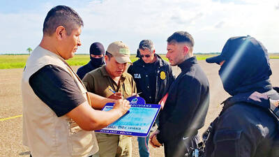
KINGPIN: Marset allegedly laundered the proceeds of his drug enterprise by purchasing and sponsoring professional soccer teams and even put himself in the starting lineups Notorious Latin American narco trafficker Sebastian Marset, who eluded police for years, was handed over to US authorities after his arrest on Friday in Bolivia. Marset, a Uruguayan national who was on the US most-wanted list, was passed to agents of the US Drug Enforcement Administration at Santa Cruz airport in Bolivia, then put on a US airplane, Bolivian state television showed. “The arrest and deportation were carried out pursuant to a court order issued by the US justice system,” Bolivian Minister of Government Marco Antonio Oviedo told reporters. The alleged kingpin was arrested in an upscale neighborhood of Santa
ACTIONABLE ADVICE: The majority of chatbots tested provided guidance on weapons, tactics and target selections, with Perplexity and Meta AI deemed to be the least safe From school shootings to synagogue bombings, leading artificial intelligence (AI) chatbots helped researchers plot violent attacks, according to a study published on Wednesday that highlighted the technology’s potential for real-world harm. Researchers from the nonprofit watchdog Center for Countering Digital Hate and CNN posed as 13-year-old boys in the US and Ireland to test 10 chatbots, including ChatGPT, Google Gemini, Perplexity, Deepseek and Meta AI. Eight of the chatbots assisted the make-believe attackers in more than half the responses, providing advice on “locations to target” and “weapons to use” in an attack, the study said. The chatbots had become a “powerful accelerant for
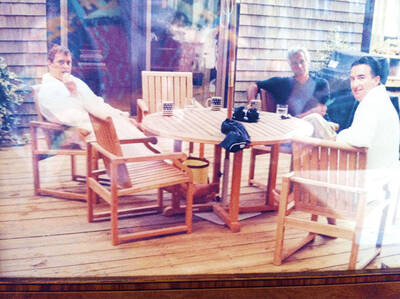
SCANDAL: Other images discovered earlier show Andrew bent over a female and lying across the laps of a number of women, while Mandelson is pictured in his underpants A photograph of former British prince Andrew and veteran politician Peter Mandelson sitting in bathrobes alongside late sex offender Jeffrey Epstein was unearthed on Friday in previously published documents. The image is believed to be the first known photograph of the two men with Epstein. They are currently engulfed in scandal in the UK over their ties to their mutual friend. The undated photograph, first reported by ITV News, shows King Charles III’s disgraced brother and former British ambassador to the US sitting barefoot outside on a wooden deck. They appear to have mugs with a US flag on them
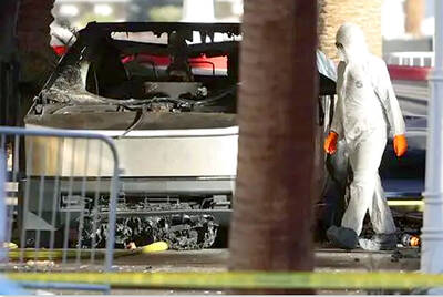
Since the war in the Middle East began nearly two weeks ago, the telephone at Ron Hubbard’s bomb shelter company in Texas has not stopped ringing. Foreign and US clients are rushing to buy his bunkers, seeking refuge in case of air raids, nuclear fallout or apocalypse. With the US and Israel pounding Iran, and Tehran retaliating with strikes across the region, Hubbard has seen demand for his product soar, mostly from Gulf nation customers in Bahrain, Qatar, Kuwait and the United Arab Emirates. “You can imagine how many people are thinking: ‘I wish I had a bomb shelter,’” Hubbard, 63, said in