Taiwanese scientists will complete the system integration of the nation's second satellite, ROCSAT-2, and tests of its subsystems later this month, to ensure that the satellite will be launched on schedule by the end of this year, officials of the National Science Council said yesterday.
At the Hsinchu-based National Space Program Office (NSPO), scientists and engineers are busy integrating the 760kg low-earth-orbit remote sensing satellite. The satellite's primary mission will be to acquire images of the terrestrial and marine environment throughout Taiwan, its remote islands and surrounding ocean for civil applications.
In addition, the satellite will also carry a `Sprites Imager' scientific instrument to study the electrodynamical coupling between thunderclouds and the upper atmosphere by taking images of lightning discharges.
Yesterday, the NSPO revealed its successful development of ROCSAT-2's Image Processing System, which has been developed over 26 months. Officials said the system will be combined with a front-end X-band antenna to form a complete satellite-image data-receiving and processing station.
The antenna system can also receive data from other satellites. Since November last year, the NSPO has provided the Central Weather Bureau with images for further analysis to enhance weather prediction.
Through future international cooperation, officials said, ROCSAT-2 will acquire pictures not only of Taiwan but of places all over the world, further enriching the database of images.
"We are now in the final stages of testing the performance of imagers on the satellite, which will be operating at a height of 891km above the Earth," Chang Guey-shin (
The ROCSAT-2 will circle the Earth 14 times a day and will fly over Taiwan twice a day, once in daylight and once during the night.
The multi-mission center at the NSPO is connected with other stations in Chungli and Tainan in order to integrate and analyze data of real-time images.
After its implementation, the Image Processing System will serve many domestic users, ranging from universities to government agencies and research institutions.
For an island prone to natural disasters resulting from earthquakes and typhoons, the timely availability of remote-sensing data is critical in the aftermath of such disasters. Officials said that images with a 2m resolution will be available within three hours after an application has been filed.
According to NSPO Director Lee Lou-chuang (
In a few months time, the satellite with a five-year lifespan will be shipped to Vandenburg Air Force Base in California for launch.
Vice Chairman Hsieh Ching-chih (
"Through the successful development of the Image Processing System, we foresee that the NSPO will play a leading role in future international cooperation in satellite programs," Hsieh said.
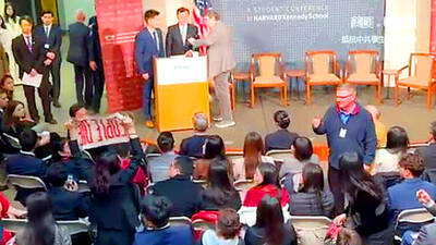
A group of Taiwanese-American and Tibetan-American students at Harvard University on Saturday disrupted Chinese Ambassador to the US Xie Feng’s (謝鋒) speech at the school, accusing him of being responsible for numerous human rights violations. Four students — two Taiwanese Americans and two from Tibet — held up banners inside a conference hall where Xie was delivering a speech at the opening ceremony of the Harvard Kennedy School China Conference 2024. In a video clip provided by the Coalition of Students Resisting the CCP (Chinese Communist Party), Taiwanese-American Cosette Wu (吳亭樺) and Tibetan-American Tsering Yangchen are seen holding banners that together read:

UNAWARE: Many people sit for long hours every day and eat unhealthy foods, putting them at greater risk of developing one of the ‘three highs,’ an expert said More than 30 percent of adults aged 40 or older who underwent a government-funded health exam were unaware they had at least one of the “three highs” — high blood pressure, high blood lipids or high blood sugar, the Health Promotion Administration (HPA) said yesterday. Among adults aged 40 or older who said they did not have any of the “three highs” before taking the health exam, more than 30 percent were found to have at least one of them, Adult Preventive Health Examination Service data from 2022 showed. People with long-term medical conditions such as hypertension or diabetes usually do not
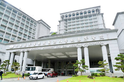
POLICE INVESTIGATING: A man said he quit his job as a nurse at Taipei Tzu Chi Hospital as he had been ‘disgusted’ by the behavior of his colleagues A man yesterday morning wrote online that he had witnessed nurses taking photographs and touching anesthetized patients inappropriately in Taipei Tzu Chi Hospital’s operating theaters. The man surnamed Huang (黃) wrote on the Professional Technology Temple bulletin board that during his six-month stint as a nurse at the hospital, he had seen nurses taking pictures of patients, including of their private parts, after they were anesthetized. Some nurses had also touched patients inappropriately and children were among those photographed, he said. Huang said this “disgusted” him “so much” that “he felt the need to reveal these unethical acts in the operating theater
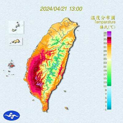
Heat advisories were in effect for nine administrative regions yesterday afternoon as warm southwesterly winds pushed temperatures above 38°C in parts of southern Taiwan, the Central Weather Administration (CWA) said. As of 3:30pm yesterday, Tainan’s Yujing District (玉井) had recorded the day’s highest temperature of 39.7°C, though the measurement will not be included in Taiwan’s official heat records since Yujing is an automatic rather than manually operated weather station, the CWA said. Highs recorded in other areas were 38.7°C in Kaohsiung’s Neimen District (內門), 38.2°C in Chiayi City and 38.1°C in Pingtung’s Sandimen Township (三地門), CWA data showed. The spell of scorching