A People First Party (PFP) lawmaker yesterday quoted a Chinese official as saying that relations between Taiwan and China were on an even footing for the time being.
PFP lawmaker and former speaker of the Legislative Yuan Liu Sung-fan (
"The official's remarks indicate that relations across the Taiwan Strait will remain stable, at least for now," Liu said.
But Liu, who has been leading a group of lawmakers from the opposition party on a visit to China, said Chen didn't say specifically how long the current calm in cross-strait relations would remain.
Liu said many in China are concerned about cross-strait relations after Taiwan made its first democratic transition of power by electing a DPP president.
Liu said he had asked the official whether there would be any change in Beijing's policy toward Taiwan following the mainland leadership's recent policy review meeting in Beidaihe.
"The official just said the two sides of the Taiwan Strait will have a period of quietness, but he didn't elaborate on the meaning of quietness," Liu said.
The PFP group briefed the press yesterday in Shanghai on the results of its mainland visit. Liu said the group had met with senior mainland officials in Beijing to discuss cross-strait problems and difficulties faced by Taiwan investors in China.
"No matter what officials have said about cross-strait relations, my observation is that China wants an early opening for direct cross-strait trade, shipping, mail and transportation links," Liu said.
Moreover, Liu said, China still welcomes Taiwan investments on the mainland. "Although our government adopts a `no haste, be patient' policy to discourage our businessmen from starting new cross-strait investment projects, mainland authorities will continue their efforts to attract Taiwan capital," he said.
After extensive talks with Taiwan businessmen based in China, Liu said most of them hope to see an early resumption of cross-strait dialogue to resolve many practical issues.
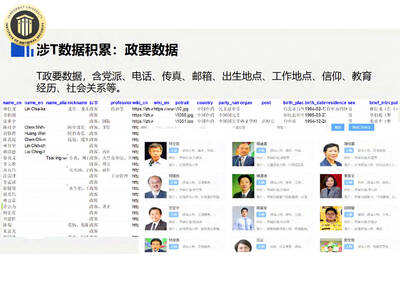
NETWORK-MAPPING PROJECT: The database contains 170 detailed files of Taiwanese politicians and about 23 million records of household registration data in Taiwan China has developed a network-mapping project targeting political figures and parties in Taiwan to monitor public opinion during elections and to craft tailored influence campaigns aimed at dividing Taiwanese society, according to documents leaked by Chinese technology firm GoLaxy (中科天璣). The documents, collected by Taipei-based Doublethink Lab, showed a database was specifically created to gather detailed information on Taiwanese political figures, including their political affiliations, job histories, birthplaces, residences, education, religion and a brief biography about them. Several notable Taiwanese politicians are in the database, including President William Lai (賴清德), former president Tsai Ing-wen (蔡英文), Minister of Foreign Affairs Lin Chia-lung (林佳龍),
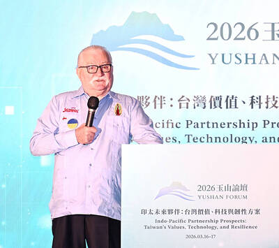
RECOGNITION: Former Fijian prime minister Mahendra Chaudhry said that Taiwan’s New Southbound Policy serves as a stabilizing force in the Indo-Pacific region Taiwan can lead the unification of the Chinese people, Nobel Peace Prize laureate and former Polish president Lech Walesa said in Taipei yesterday, adding that as the world order is changing, peaceful discussion would find good solutions, and that the use of force and coercion would always fail. Walesa made the remarks during his keynote address at a luncheon of the Yushan Forum in Taipei, titled “Indo-Pacific Partnership Prospects: Taiwan’s Values, Technology and Resilience,” organized by the Taiwan-Asia Exchange Foundation with the Ministry of Foreign Affairs. Walesa said that he had been at the forefront of a big peaceful revolution and “if
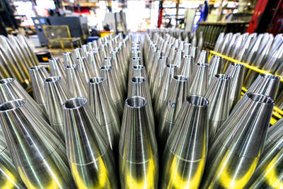
UPGRADED MISSILE: The Chungshan Institute of Science and Technology is reportedly to conduct a live-fire test of the Hsiung Feng III anti-ship missile on Thursday next week The US Army is planning to build new facilities to boost explosives production and strengthen its supply chain, a move aimed at addressing munitions shortages and supporting obligations to partners including Taiwan, Ukraine and Israel, Defense News reported. The army has issued a sources sought notice for a proposed Center of Excellence at the Blue Grass Army Depot in Kentucky, the report said. The facility would serve as a hub within the US industrial base for the production of key military explosives, including research department explosives (RDX) and high melting explosives (HMX), while also supporting research and development of next-generation materials. The proposed
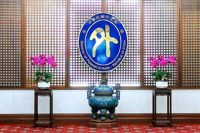
SOUTH KOREA DISPUTE: If Seoul continues to ignore its request, Taiwan would change South Korea’s designation on its arrival cards, the foreign ministry said If South Korea does not reply appropriately to a request to correct Taiwan’s name on its e-Arrival card system before March 31, the government would take corresponding measures to change how South Korea is labeled on the online Taiwan Arrival Card system, the Ministry of Foreign Affairs said yesterday. South Korea’s e-Arrival card system lists Taiwan as “China (Taiwan)” in the “point of departure” and “next destination” fields. Taipei has asked Seoul to change the wording. Since March 1, South Koreans who hold government-issued Alien Resident Certificates (ARC) have been identified as from “South Korea” rather than the “Republic of Korea,” the