DPP Legislator Su Huan-chih (蘇煥智) presented what he claimed was a land deed to reporters yesterday, saying it was evidence linking KMT presidential candidate Lien Chan (連戰) to an alleged case of land speculation in 1993.
Another lawmaker, Wu Tse-yuan (
Su alleged that Lien, who was premier at that time, lent NT$32.68 million to Wu, who was then running for Pingtung (
Lien did not report the transfer to the watchdog Control Yuan until after the transaction was discovered. The legislator called Lien and Wu "liars" for saying the money was used for campaign activities.
Documents appeared to indicate that the money was trans-ferred by Lien Fang-yu (
Chen Shei-saint (
Chen said Lien had accrued his assets through investments in land and stocks and that his wealth had not been gained through embezzlement.
An investigation conducted by the Control Yuan proved that Wu borrowed the money from Lien as campaign funds, but that the money was then used as a land investment, which they said could not be proved to be related to Lien.
Wu himself has been the subject of considerable controversy, having been sentenced to life imprisonment in 1996 over a bribery scandal.
His case has been twice referred from the Supreme Court back to the high court and last December -- despite the convictions pending against him -- was forwarded to the legislature.

RESILIENCE: Taiwan plays a key role in semiconductors, energy, information infrastructure and advanced manufacturing, AIT Director Raymond Greene said Taiwan’s continued investment in deterrence and resilience remains vital, especially in uncrewed systems and other emerging technologies, American Institute in Taiwan (AIT) Director Raymond Greene said yesterday. Greene made the remarks at the annual National Strategic Summit on Supply Chain Resilience held by the Research Institute for Democracy, Society and Emerging Technology (DSET), a government-backed think tank. As Taiwan last year became the US’ fourth-largest trading partner and supply chain security is becoming more important, cooperation in emerging technologies continues to deepen between the two countries, he said. The US is committed to accelerating innovation, building key infrastructure, strengthening cooperation
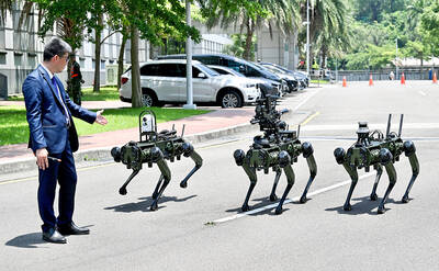
The National Chungshan Institute of Science and Technology yesterday showcased its locally developed variants of the Vision 60 robotic patrol dog, which it plans to deploy on the nation’s outlying territories in the South China Sea. The variants were produced under the Joint Lab project — created by the institute and domestic companies — and assembled with domestically produced motors, lenses and artificial intelligence (AI) systems alongside licensed tech from the US, Missile and Rocket Systems Research Division deputy director Jen Kuo-kang (任國光) told the media event at a military base in Taipei’s Dazhi (大直) area. Taiwan has built up its strengths

RIGHT DIRECTION: Taiwan’s efforts to prevent forced labor include a proposal to ‘fully prohibit’ employers from withholding workers’ documents, an official said Taiwan is to establish a mechanism to restrict imports of goods linked to forced labor, the Executive Yuan said yesterday, after the US proposed imposing additional tariffs on Taiwanese goods over labor concerns. “The Ministry of Labor and the Ministry of Economic Affairs are to establish an interministerial review procedure,” Executive Yuan spokesperson Michelle Lee (李慧芝) said at a news briefing in Taipei. “The government is to use the Foreign Trade Act [貿易法] as the legal basis to restrict imports of goods produced with forced labor” and bring its supply chain governance more in line with international standards on human rights, resilience
NOT IMMEDIATE: Taiwan has a chance to appeal the proposed 10 percent tariff before it starts, while other countries face a 12.5 percent tariff from the trade office Taiwan is among 60 economies determined by the US to have failed to impose or enforce a ban on the importation of goods produced with forced labor, according to a notice released on Tuesday by the Office of the US Trade Representative (USTR), which proposed imposing an additional 10 percent or more tariff on them. The USTR in a statement said that following an investigation, it had determined under Section 301 of the Trade Act of 1974 that the failure of the 60 economies to impose and effectively enforce a prohibition on the importation of goods produced with forced labor is