More than a month after the 921 earthquake, the National Science Council (NSC) has completed a detailed map of the Chelungpu fault (
Highly anticipated by building contractors, the map of the Chelungpu fault, which has been drawn to a 1:5,000 ratio, was produced by 21 academics who have been conducting field investigations since the earthquake.
At the time of the quake, the most precise fault maps available were those of a 1:100,000 ratio, while the official one available from the Central Geological Survey (CGS) was of a 1:500,000 ratio.
"The NSC's newly produced Chelungpu fault map will be useful in considering rebuilding plans because construction prohibition zones and restricted zones can be identified by referring to it," Huang Chi-yue (
Huang said it would be easy to tell how far the fault is from damaged structures if CPA officials are making administrative maps of townships along the Chelungpu fault using the same scale as that of the NSC map.
"However, to better identify permanent prohibited zones and restricted zones along the fault, geologists have been given a tougher job -- producing a map of the same fault with a 1:1,000 ratio. This more detailed map should be completed by Dec. 15," he said.
NSC director Huang Chen-tai (
The 1:1,000 map, he added, would present the recorded geologic characters of the fault and would become an excellent reference to other thrust faults in western Taiwan.
Huang said scientists had discussed how to produce a detailed overall fault map, which would be more precise than any fault maps currently in use.
One of the challenges for contractors during rebuilding will be understanding exactly where the fault line lies. The ability to pinpoint the exact location of the fault has become a contentious point between construction engineers and scientists.
Taiwan is creased with a number of fault lines and geologists have said that it is impractical, if not impossible to map out all sections of every fault line on the island. Moreover, they say that increasing the detail of maps from 1:100,000 -- the ratio used by geologists for making scientific surveys -- to 1:1,000 in an invitation for error.
Builders argue that the more detailed maps are necessary for making blueprints that have the degree of accuracy that they are familiar with.
The builders say that maps currently available do not have nearly enough detail to allow them to know with certainty if they are building the specified distance away from an active fault line.
Scientists say the priority should be producing an official fault map using a 1:25,000 ratio, a standard which has been adopted by the US, Japan and other countries.
"It's not realistic to produce precise fault maps at 1:1,000. For geologists, the difficulty is knowing exactly where the faults are, especially those deep underground," said Shih Ruey-chyuan (石瑞銓), a seismologist from National Chung Cheng University.
"Instead of relying solely on fault maps, builders should make comprehensive site inspections before they break ground on any structure," said Tsai Yi-ben (蔡義本), professor and dean of the College of Earth Sciences at National Central University.
According to one British scientist who worked in Taiwan after the quake, fault maps are an essential guide for builders.
"If detailed maps are not available at construction sites, engineers will have to deal more with local conditions," said Colin Taylor, a civil engineering professor from Bristol University.
He said that the fault maps are needed either for scientists to identify the sources and mechanism of major earthquakes or for engineers to use during construction.
Although the UK is relatively small, its geology has been studied for more than 150 years.
"The governmental British Geological Survey has produced quite detailed geological maps of the UK in various scales. The most detailed one is 1:1,000," Taylor said.
Another engineer, Dave Edge from the UK-based WS Atkins Group, an engineering consulting firm, stressed the need for accurate maps: "One cannot be sure that the law [prohibiting the building of houses closer than 15 meters from a fault line] is successful unless one knows actually where the fault lines are."
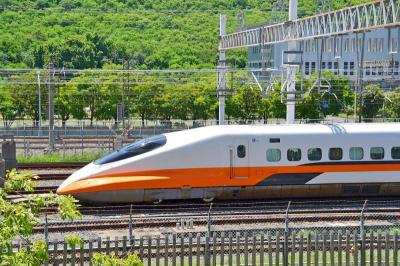
A signaling system malfunction disrupted high-speed rail (HSR) services beginning at 8am today, with trains temporarily reduced to three northbound and three southbound trains per hour as authorities conduct inspections. The malfunction occurred on a section of track in Miaoli County during pre-operation checks early this morning, forcing northbound and southbound trains to use a single track, the HSR operator said. The regular schedule has been replaced with three hourly trains offering only nonreserved seating in each direction, stopping at every station, it said, adding that business class cars would still have reserved seating. Departures from terminal stations are scheduled at the top

Taiwan is still in the process of assessing the possibility of recruiting workers from Eswatini, the Ministry of Foreign Affairs said yesterday, adding that its goal is to help Eswatini upgrade its vocational training centers. If there are plans to recruit workers from Eswatini, safeguarding national security, protecting public health and ensuring the employment rights of Taiwanese would be prerequisites, Department of West Asian and African Affairs Director-General Yen Chia-liang (顏嘉良) told a news conference. Key considerations would also include filling labor shortages in specific industries, and fostering bilateral professional and technical exchanges, he said. Yen was asked about the progress of labor
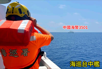
VERBOSE VESSELS: A CGA cutter and a China Coast Guard exchanged verbal barbs for more than a day in Taiwanese-controlled waters before the Chinese vessel left The Taiwanese and Chinese coast guards had a standoff near the strategically located Pratas Islands (Dongsha Islands, 東沙群島) in the north of the South China Sea, the Coast Guard Administration (CGA) said yesterday. The two sides engaged in intense radio exchanges over sovereignty claims during the 33-hour standoff. China Coast Guard vessel 3501 eventually left the restricted waters, 26.6 nautical miles (49.2km) west of the Pratas Islands, at 5pm yesterday, the CGA said. Lying approximately between southern Taiwan and Hong Kong, the Taiwan-controlled Pratas are seen by some security experts as vulnerable to Chinese attack due to their distance — more than
A US uncrewed surface vessel (USV) encountered multiple Chinese warships during an autonomous transit of the Taiwan Strait, US defense company Seasats said in a statement on Wednesday. Seasats announced that a Lightfish USV had completed the first autonomous transit of the Taiwan Strait. Over five days, the USV traversed the entire length of the Strait while constantly monitoring surface vessel traffic, the company said. The Lightfish encountered multiple Chinese warships, one of which was a Chinese People’s Liberation Army Navy (PLAN) Type 056 corvette, it said. The Chinese vessels were operating “well within Taiwan’s exclusive economic zone without transmitting their identity via the