FORMOSAT-2, the nation’s first locally developed ionospheric research and surface mapping satellite, has been decommissioned after 12 years in operation.
The satellite had remained operational eight years past its expected lifespan of five years, but a series of equipment failures finally forced the National Space Organization (NSPO) to pull the plug.
One of its four reaction wheels, which rotate and position the satellite, malfunctioned in 2013, and another one stopped working in June, which meant FORMOSAT-2 could no longer take pictures or make observations, the agency said.
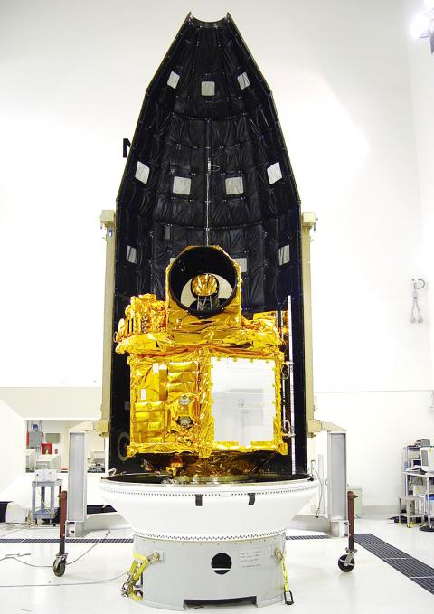
Photo courtesy of the National Space Organization
After weeks of repair efforts, the NSPO determined that the problematic wheels could not be fixed and that FORMOSAT-2 had to be retired.
The agency made its last contact with FORMOSAT-2 during a decommissioning ceremony on Friday at its headquarters in Hsinchu, bringing an end to the nation’s most successful surveillance satellite program.
“With gratitude, we congratulate FORMOSAT-2 for the service it provided. It accompanied us over the past 12 years as we grew up. It is like an old friend, or more like a teacher,” NSPO Director Chang Guey-shin (張桂祥) said. “The satellite made an unparalleled contribution to the nation’s space development.”
The satellite, which cost NT$4.6 billion (US$145.5 million at current exchange rates) to build, was launched on May 21, 2004, from Vandenberg Air Force Base in California.
It circles the Earth once every 103 minutes and passes over Taiwan twice a day.
It was the nation’s only satellite with a daily revisit capability, meaning it could take pictures of a given location every day, and the only one that could photograph the polar regions.
The satellite took about 2.55 million pictures of the Earth’s surface.
The pictures brought in about NT$600 million in revenue, while images worth about NT$1.1 billion were provided to 191 government agencies and 176 academic institutions in Taiwan free of charge.
The satellite helped with scientific research, environmental monitoring, urban planning and natural disaster prevention and evaluation.
FORMOSAT-2 was used in 343 disaster response missions, providing authorities with immediate images of damaged areas during the Indian Ocean earthquake and tsunami in December 2004, Hurricane Katrina in the US in 2005, the Sichuan earthquake in China in 2008, Typhoon Morakot in Taiwan in 2009 and the Tohoku earthquake and tsunami in Japan in 2011.
For eight days after Morakot hit Taiwan, the satellite took detailed pictures of all areas damaged by the typhoon to help the government evaluate the situation and plan its emergency response.
FORMOSAT-2 was also the first satellite to observe the transient luminous event — an electrical-discharge phenomena well above the altitudes of normal lightning and storm clouds — and its observations have been cited in numerous academic research.
Additional reporting by staff writer

National Taiwan University (NTU) yesterday said it disqualified a person from an entrance examination for using AI smart glasses to cheat, along with two others for making untruthful statements in their curriculum vitae. The three applicants were given null scores, Taiwan’s highest-ranked university said, calling on prospective students to be honest in the admissions process. NTU registrar Lee Hung-sen (李宏森) said that the cheating applicant wore a hat and thick-rimmed glasses to the second written exam for medical school, claiming that they felt cold. Suspicions were aroused when the applicant stared oddly at the test for long stretches while steadily bringing the paper
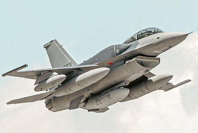
66 FIGHTER JETS: The aircraft is likely undergoing preparations for its transfer to Taiwan — a significant step forward in the nation’s modernization program, a lawmaker said The first of Taiwan’s order of F-16V Block 70 aircraft has been sighted in Texas ahead of delivery, Democratic Progressive Party (DPP) Legislator Wang Ting-yu (王定宇) said. Taiwan’s first F-16V Block 70 two-seat aircraft, tail number 6831, was seen flying from Lockheed Martin’s production facility in Greenville, South Carolina, to Naval Air Station Joint Reserve Base Fort Worth in Texas, Wang wrote on Facebook yesterday. The plane is likely undergoing preparations for its transfer to Taiwan, marking a significant step forward in the Republic of China Air Force’s modernization program, Wang said, citing military analysts. The F-16V Block 70 is a new-build version
MILITARY ISSUES: A partisan divide between the Cabinet and the legislature ‘raised questions about Taiwan’s ability to adequately fund its defense,’ the report said Taiwan’s defense budget, military personnel numbers and resilience are challenges to its ability to meet national defense goals, the US Naval Institute said in a report published on Tuesday. In response to the perception of a growing military threat posed by China, Taiwan has embarked on an effort to enhance the capabilities needed to deter an attempt by Beijing to annex the nation by force, the institute said in the US Congressional Research Service report, titled Taiwan: Defense and Military Issues, which was filed on Thursday last week. Taiwan’s defense budget increased by about 7.5 percent from 2024 to last year, it

NOT JUST NUMBERS: What matters to intelligence work is crucial, reliable information, so even a few credible leads can be highly valuable to national security, a legislator said The National Security Bureau (NSB) yesterday said it has finished the establishment of an information-reporting channel for Chinese nationals, the aim of which is to broaden intelligence gathering on China’s political, military, economic and social developments. Chinese nationals can submit information on the Web page, https://report.nsb.gov.tw, the NSB said in a statement. The move aims to expand the bureau’s diverse intelligence sources and is pursuant to the National Intelligence Services Act (國家情報工作法), it said, adding that it referenced practices adopted by intelligence agencies in the US, the UK and Israel. An increasing number of people are approaching Taiwanese agencies to provide information, as